


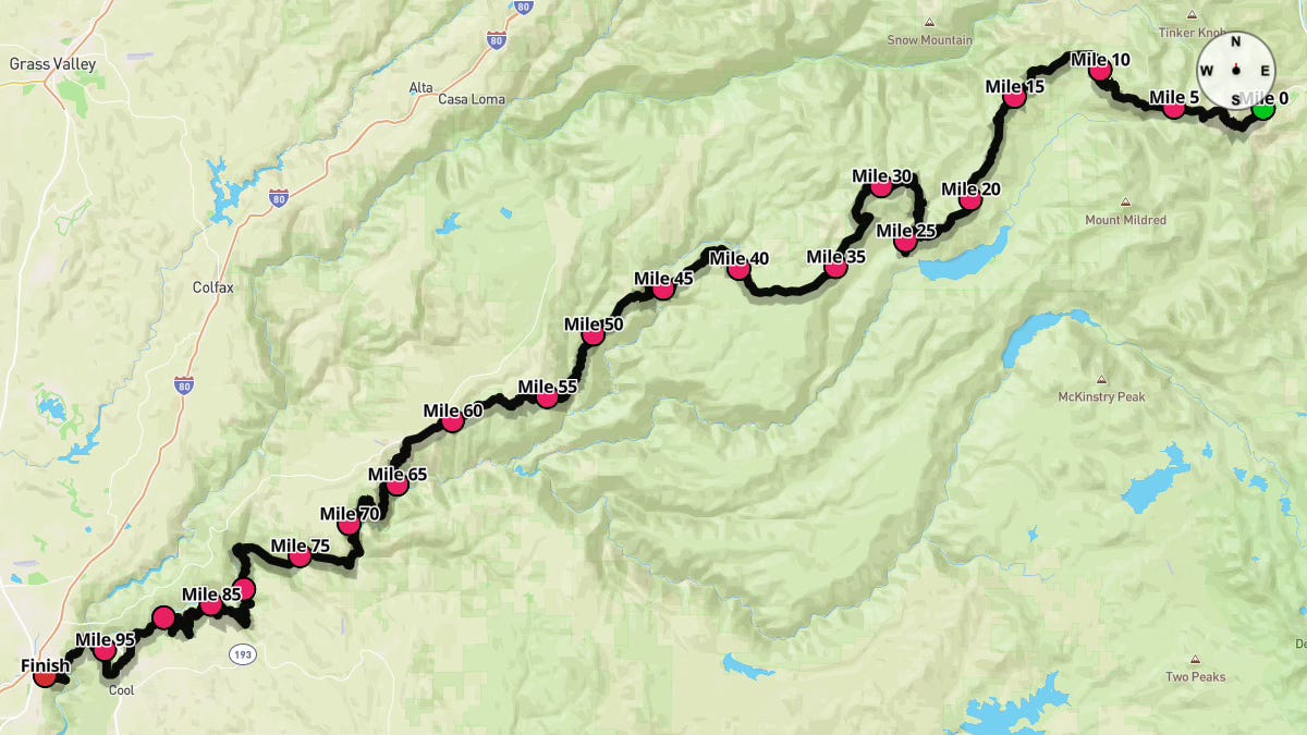
The 2025 Western States 100 Course Guide - Imperial Edition (Miles & Feet)
The golden hour's calling as we race against the night - Living life in just one day, through the valleys, reaching heights

Notes: This guide is based on a Run Ready Certified GPX file, created through a standardized process that combines official course maps, measurement certificates, and other plotting techniques. The official course distance is 100.2 miles. The certified GPX file measures the course at 99.83 miles, so distances in the guide are approximate. Additionally, and as shown below, different platforms will calculate different totals from the same set of coordinates.
This is the Imperial Edition (Miles & Feet) of the course guide. The Metric Edition (Kilometers & Meters) is coming soon.
Course Overview
The Western States Endurance Run stands as a testament to human endurance, tracing a path through history along one of ultrarunning's most revered courses. Following the historic Western States Trail from Olympic Valley to Auburn, California, runners journey through the rugged High Sierra wilderness and California's storied gold country. This demanding 100-mile odyssey challenges athletes with relentless climbs and descents across an ever-changing landscape, calling for thorough physical and mental preparation.
The race begins at 5:00 a.m. on the last full weekend in June, with runners setting off in pre-dawn darkness before the 5:35 a.m. sunrise. Participants face a gauntlet of temperature swings throughout their journey. Near Olympic Valley, June temperatures typically range from crisp 42°F mornings to comfortable 73°F afternoons. Yet the course transforms dramatically, with Auburn's exposed canyons bringing average highs of 88°F and lows of 61°F. Last year's race day saw temperatures climb from 75°F at the start to reportedly into 90s°F along the course; manageable conditions that still demanded respect from every runner. Success requires preparing for both mountain chill and canyon heat.
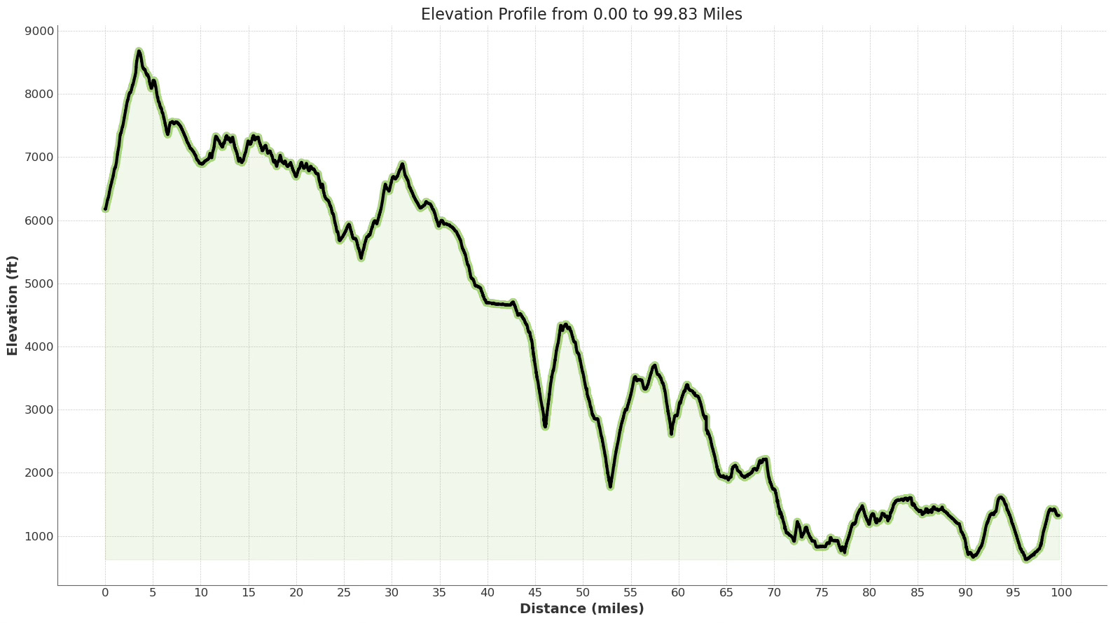
The course delivers punishing elevation changes, with runners climbing 18,756.56 feet and descending 23,608.92 feet. Trail surfaces shift constantly—from forest paths and rocky high country terrain to dirt roads and the notorious sun-baked canyons below. Conquering this course demands adaptability and grit, as runners navigate both the physical challenges of the terrain and the toll of temperature swings.
More than a race, Western States follows a trail carved by fortune-seekers during the 1850s gold rush. Each step connects today's runners to the miners and prospectors who first blazed this path, carrying forward their legacy of determination. The event thrives through the community around it and the dedication of approximately 1,500 volunteers whose commitment proves essential to every runner's journey.
Course Briefing
Miles 0-10.3 (Climb to Emigrant Pass & Descent to Lyon Ridge)
The Western States 100 begins at 5:00 a.m. in Olympic Valley, California. You'll start running in the predawn darkness, just moments before civil twilight touches the sky at 5:05 a.m. For safety, all runners carry two flashlights to guide their way.
The journey begins with the defining climb from the valley floor to Emigrant Pass, the highest point on the course. Starting on Village East Road, you'll quickly transition to Granite Chief Road before finding the trail. This opening ascent gains over 2,500 feet in just 3.6 miles, carrying you to the course's summit before plunging into a dramatic descent toward Lyon Ridge. The mountain trail beneath your feet will be rocky and technical, demanding focus and determination. After conquering the initial climb, you'll face steep grades as you descend toward Lyon Ridge, testing both courage and control.


Key Challenges
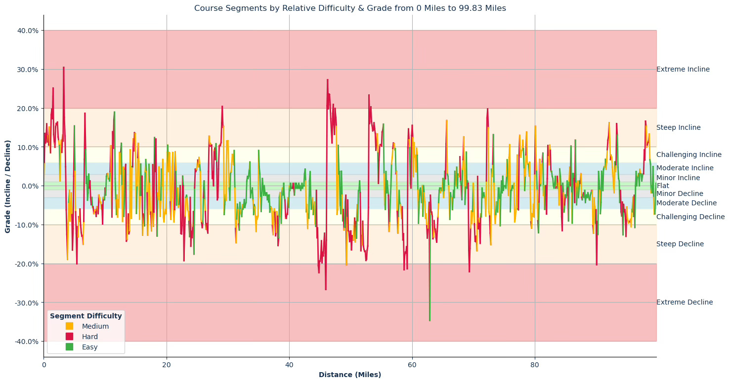
The primary challenge awaits you right from the starting line: a demanding, sustained climb to Emigrant Pass that rises 2,480.3 feet in just 3.58 miles (average grades of 13.59% and 13.28%). This early test will push both your legs and cardiovascular system when you're fresh and eager. Starting conservatively on this climb becomes essential for conquering the full 100 miles ahead.
After cresting the initial climb, you'll face a significant descent toward Lyon Ridge (miles 5.10 to 6.53). This downhill stretch presents steep and extreme decline grades reaching -20%, demanding careful footwork and controlled pacing to preserve your muscles for the long journey ahead.
Significant Climbs (≥3% grade & ≥0.1 miles)
Climb #1: Mile 0.00 to 2.56, 2.56 mi, avg grade 13.59%, total gain 1837.3 ft
Climb #2: Mile 2.66 to 3.58, 0.92 mi, avg grade 13.28%, total gain 643.0 ft
Climb #3: Mile 4.90 to 5.10, 0.20 mi, avg grade 9.57%, total gain 101.7 ft
Climb #4: Mile 6.53 to 6.84, 0.30 mi, avg grade 11.52%, total gain 183.7 ft
Climb #5: Mile 10.22 to 10.42, 0.20 mi, avg grade 3.06%, total gain 32.8 ft
Significant Descents (≤-3% grade & ≥0.1 miles)
Descent #1: Mile 3.58 to 4.09, 0.51 mi, avg grade -10.36%, total drop 278.9 ft
Descent #2: Mile 4.19 to 4.40, 0.20 mi, avg grade -7.62%, total drop 82.0 ft
Descent #3: Mile 4.50 to 4.80, 0.30 mi, avg grade -11.71%, total drop 187.0 ft
Descent #4: Mile 5.10 to 6.53, 1.43 mi, avg grade -11.30%, total drop 853.0 ft
Descent #5: Mile 7.04 to 7.14, 0.10 mi, avg grade -3.70%, total drop 19.7 ft
Descent #6: Mile 7.55 to 8.89, 1.33 mi, avg grade -5.79%, total drop 406.8 ft
Descent #7: Mile 8.99 to 9.91, 0.92 mi, avg grade -4.72%, total drop 229.7 ft
Descent #8: Mile 11.03 to 11.13, 0.10 mi, avg grade -8.06%, total drop 42.7 ft
Aid Stations
Lyon Ridge (10.3 miles)
Medical: No
Drop Bags: No
Crew Access: No
Pacer Change: No
Cutoff: 10:30am
Points of Interest
Emigrant Pass (approx. mile 4)
Miles 10.3-24.4 (Lyon Ridge to Duncan Canyon)
After the initial major climb and descent, this section follows the natural rhythm of the ridge tops before dropping into the Duncan Canyon aid station. You'll move through forested trails, finding yourself in a series of shorter ups and downs that range from moderate to challenging to steep. While none of these individual climbs match the scale of that first ascent, their combined effect tests your confidence in your legs and spirit. As you approach Duncan Canyon, you'll begin a significant descent that works different muscles. The terrain shifts beneath your feet but remains true to the trail.


Key Challenges
Managing pace and effort through the numerous smaller inclines and declines is key. The accumulated fatigue from these rolling sections can build quietly but persistently.
The significant descent approaching Duncan Canyon (miles 22.75 to 24.49) includes steep and extreme decline portions (up to -19% grade), demanding your full attention and controlled form after many miles of varied terrain.
Significant Climbs (≥3% grade & ≥0.1 miles)
Climb #6: Mile 10.73 to 10.93, 0.21 mi, avg grade 6.96%, total gain 75.5 ft
Climb #7: Mile 11.13 to 11.54, 0.41 mi, avg grade 14.84%, total gain 321.5 ft
Climb #8: Mile 12.26 to 12.66, 0.41 mi, avg grade 7.78%, total gain 167.3 ft
Climb #9: Mile 12.86 to 12.97, 0.10 mi, avg grade 4.81%, total gain 26.2 ft
Climb #10: Mile 13.17 to 13.37, 0.20 mi, avg grade 4.87%, total gain 52.5 ft
Climb #11: Mile 13.99 to 14.09, 0.10 mi, avg grade 9.21%, total gain 49.2 ft
Climb #12: Mile 14.29 to 15.01, 0.72 mi, avg grade 8.86%, total gain 334.6 ft
Climb #13: Mile 15.22 to 15.52, 0.31 mi, avg grade 8.13%, total gain 131.2 ft
Climb #14: Mile 15.72 to 15.82, 0.10 mi, avg grade 5.58%, total gain 29.5 ft
Climb #15: Mile 16.44 to 16.74, 0.31 mi, avg grade 4.68%, total gain 75.5 ft
Climb #16: Mile 17.05 to 17.15, 0.10 mi, avg grade 5.50%, total gain 29.5 ft
Climb #17: Mile 17.66 to 17.77, 0.10 mi, avg grade 5.39%, total gain 29.5 ft
Climb #18: Mile 17.97 to 18.28, 0.31 mi, avg grade 9.33%, total gain 150.9 ft
Climb #19: Mile 18.69 to 18.79, 0.10 mi, avg grade 4.84%, total gain 26.2 ft
Climb #20: Mile 19.09 to 19.20, 0.10 mi, avg grade 4.27%, total gain 23.0 ft
Climb #21: Mile 19.30 to 19.40, 0.10 mi, avg grade 6.75%, total gain 36.1 ft
Climb #22: Mile 20.01 to 20.52, 0.51 mi, avg grade 7.95%, total gain 213.3 ft
Climb #23: Mile 20.83 to 21.03, 0.20 mi, avg grade 6.69%, total gain 72.2 ft
Climb #24: Mile 21.34 to 21.54, 0.20 mi, avg grade 6.15%, total gain 65.6 ft
Significant Descents (≤-3% grade & ≥0.1 miles)
Descent #9: Mile 11.65 to 11.85, 0.20 mi, avg grade -5.57%, total drop 59.1 ft
Descent #10: Mile 11.95 to 12.26, 0.31 mi, avg grade -5.68%, total drop 91.9 ft
Descent #11: Mile 12.76 to 12.86, 0.10 mi, avg grade -9.21%, total drop 49.2 ft
Descent #12: Mile 12.97 to 13.17, 0.20 mi, avg grade -5.52%, total drop 59.1 ft
Descent #13: Mile 13.37 to 13.99, 0.61 mi, avg grade -11.26%, total drop 364.2 ft
Descent #14: Mile 14.09 to 14.29, 0.21 mi, avg grade -6.35%, total drop 68.9 ft
Descent #15: Mile 15.01 to 15.11, 0.10 mi, avg grade -7.15%, total drop 39.4 ft
Descent #16: Mile 15.52 to 15.62, 0.10 mi, avg grade -8.59%, total drop 45.9 ft
Descent #17: Mile 16.03 to 16.44, 0.41 mi, avg grade -9.67%, total drop 210.0 ft
Descent #18: Mile 16.85 to 17.05, 0.21 mi, avg grade -9.67%, total drop 105.0 ft
Descent #19: Mile 17.26 to 17.66, 0.41 mi, avg grade -8.08%, total drop 173.9 ft
Descent #20: Mile 17.77 to 17.97, 0.20 mi, avg grade -8.60%, total drop 91.9 ft
Descent #21: Mile 18.38 to 18.48, 0.10 mi, avg grade -12.94%, total drop 68.9 ft
Descent #22: Mile 18.58 to 18.69, 0.10 mi, avg grade -3.59%, total drop 19.7 ft
Descent #23: Mile 18.89 to 19.09, 0.20 mi, avg grade -5.78%, total drop 62.3 ft
Descent #24: Mile 19.40 to 19.91, 0.51 mi, avg grade -7.56%, total drop 203.4 ft
Descent #25: Mile 20.52 to 20.72, 0.21 mi, avg grade -6.34%, total drop 68.9 ft
Descent #26: Mile 21.03 to 21.34, 0.30 mi, avg grade -7.17%, total drop 114.8 ft
Descent #27: Mile 21.54 to 21.64, 0.10 mi, avg grade -4.96%, total drop 26.2 ft
Descent #28: Mile 21.84 to 22.15, 0.31 mi, avg grade -4.47%, total drop 72.2 ft
Descent #29: Mile 22.25 to 22.55, 0.30 mi, avg grade -11.63%, total drop 187.0 ft
Descent #30: Mile 22.75 to 23.16, 0.41 mi, avg grade -10.56%, total drop 229.7 ft
Descent #31: Mile 23.27 to 24.49, 1.23 mi, avg grade -9.73%, total drop 629.9 ft
Aid Stations
Red Star Ridge (15.8 miles)
Medical: Yes
Drop Bags: Yes
Crew Access: No
Pacer Change: No
Cutoff: 10:30am
Duncan Canyon (24.4 miles)
Medical: No
Drop Bags: No
Crew Access: Yes 1 Vehicle Allowed
Pacer Change: No
Cutoff: 12:30pm
Points of Interest
Red Star Ridge (approx. mile 15.8)
Miles 24.4-43.3 (Duncan Canyon to Last Chance)
Leaving Duncan Canyon, the course climbs briefly before entering a stretch of undulating terrain that leads to the major aid station at Robinson Flat. This section winds through forested trails and dirt roads, offering a welcome respite before the challenges ahead. After Robinson Flat, the trail opens up as it heads toward Last Chance, presenting runners with a mix of moderate, challenging, and steep grades.
This portion includes a significant descent starting around mile 36, the longest downhill on the course by distance, which will test your leg strength and endurance. The descent carries you into the approach to the remote canyons that lie ahead.


Key Challenges
The longest downhill section of the course runs from miles 36.04 to 39.11, with an average -6.07% grade over 3.07 miles. This sustained descent, classified as a challenging decline, requires downhill running strength and can cause quad fatigue if not managed properly.
After the long descent, the trail alternates between rises and falls toward Last Chance. While there isn't a single steep climb into the aid station, the rolling terrain after mile 39.92 requires steady effort before reaching Last Chance at mile 43.3.
Significant Climbs (≥3% grade & ≥0.1 miles)
Climb #25: Mile 24.59 to 25.52, 0.93 mi, avg grade 5.04%, total gain 246.1 ft
Climb #26: Mile 26.75 to 27.37, 0.62 mi, avg grade 9.67%, total gain 315.0 ft
Climb #27: Mile 27.47 to 27.57, 0.10 mi, avg grade 3.68%, total gain 19.7 ft
Climb #28: Mile 27.67 to 28.19, 0.51 mi, avg grade 8.45%, total gain 229.7 ft
Climb #29: Mile 28.39 to 29.31, 0.92 mi, avg grade 12.60%, total gain 610.2 ft
Climb #30: Mile 29.72 to 30.13, 0.41 mi, avg grade 9.69%, total gain 210.0 ft
Climb #31: Mile 30.33 to 31.04, 0.71 mi, avg grade 6.01%, total gain 226.4 ft
Climb #32: Mile 33.39 to 33.60, 0.20 mi, avg grade 5.19%, total gain 55.8 ft
Climb #33: Mile 34.92 to 35.22, 0.31 mi, avg grade 5.66%, total gain 91.9 ft
Climb #34: Mile 42.39 to 42.59, 0.20 mi, avg grade 3.66%, total gain 39.4 ft
Climb #35: Mile 43.30 to 43.41, 0.10 mi, avg grade 3.60%, total gain 19.7 ft
Significant Descents (≤-3% grade & ≥0.1 miles)
Descent #32: Mile 25.52 to 26.03, 0.51 mi, avg grade -8.34%, total drop 226.4 ft
Descent #33: Mile 26.14 to 26.75, 0.61 mi, avg grade -9.10%, total drop 295.3 ft
Descent #34: Mile 28.19 to 28.39, 0.21 mi, avg grade -3.33%, total drop 36.1 ft
Descent #35: Mile 29.31 to 29.51, 0.20 mi, avg grade -6.14%, total drop 65.6 ft
Descent #36: Mile 29.61 to 29.72, 0.10 mi, avg grade -3.69%, total drop 19.7 ft
Descent #37: Mile 30.23 to 30.33, 0.10 mi, avg grade -3.69%, total drop 19.7 ft
Descent #38: Mile 31.15 to 32.98, 1.84 mi, avg grade -7.03%, total drop 682.4 ft
Descent #39: Mile 33.60 to 33.70, 0.10 mi, avg grade -3.07%, total drop 16.4 ft
Descent #40: Mile 34.00 to 34.92, 0.91 mi, avg grade -7.27%, total drop 351.0 ft
Descent #41: Mile 35.22 to 35.43, 0.21 mi, avg grade -4.84%, total drop 52.5 ft
Descent #42: Mile 36.34 to 36.44, 0.10 mi, avg grade -3.61%, total drop 19.7 ft
Descent #43: Mile 36.55 to 36.65, 0.10 mi, avg grade -4.16%, total drop 23.0 ft
Descent #44: Mile 36.75 to 38.39, 1.64 mi, avg grade -8.58%, total drop 741.5 ft
Descent #45: Mile 38.50 to 38.70, 0.20 mi, avg grade -8.79%, total drop 95.1 ft
Descent #46: Mile 39.11 to 39.92, 0.82 mi, avg grade -5.86%, total drop 252.6 ft
Descent #47: Mile 42.69 to 43.20, 0.51 mi, avg grade -7.64%, total drop 206.7 ft
Descent #48: Mile 43.51 to 44.33, 0.82 mi, avg grade -6.47%, total drop 278.9 ft
Aid Stations
Robinson Flat (30.3 miles)
Medical: Yes
Drop Bags: Yes
Crew Access: Yes Via Shuttle
Pacer Change: No
Cutoff: 2:10pm
Miller's Defeat (34.4 miles)
Medical: No
Drop Bags: No
Crew Access: No
Pacer Change: No
Cutoff: 3:15pm
Dusty Corners (38.0 miles)
Medical: No
Drop Bags: No
Crew Access: Yes 1 Vehicle Allowed
Pacer Change: No
Cutoff: 4:05pm
Last Chance (43.3 miles)
Medical: Yes
Drop Bags: Yes
Crew Access: No
Pacer Change: No
Cutoff: 5:25pm
Points of Interest
Robinson Flat (approx. mile 30.3)
Last Chance (approx. mile 43.3)
Miles 43.3-55.7 (The Canyons: Last Chance, Devil's Thumb, El Dorado Creek, Michigan Bluff)
This section stands as the most defining and challenging portion of the Western States 100. You'll descend steeply into and climb out of three major canyons: first the descent from Last Chance with its subsequent climb, then the descent and climb surrounding Devil's Thumb, and finally the descent into El Dorado Creek, culminating at Michigan Bluff. The terrain proves rough, rocky, and exposed, marked by extreme and steep ups and downs. Here, temperatures often rise significantly due to the lower elevation and exposure.


Key Challenges
The descent into the first canyon after Last Chance (miles 44.43 to 46.06) plunges down extreme grades averaging -17.39%, calling for precise control and careful footing. Without pause, the trail launches into the steepest sustained climb on the course (miles 46.06 to 47.69), averaging 18.67% as it powers out of the canyon. This ascent demands patient, determined hiking, often during the most intense heat of the day.
The drop into El Dorado Creek (miles 51.57 to 52.90) presents the course's steepest downhill section, averaging over -15% grade. This punishing descent tests even the strongest quads, already fatigued from miles of mountain running. Rising immediately from the creek bottom comes another fierce climb (miles 52.90 to 54.43), the longest sustained ascent averaging over 10% grade following the initial Olympic Valley climb.
Throughout this section, managing heat and hydration becomes essential for survival and success. The exposed canyon environment can create extreme temperatures that intensify the already demanding terrain, making every decision about pace and hydration critical to reaching the next aid station.
Significant Climbs (≥3% grade & ≥0.1 miles)
Climb #36: Mile 46.06 to 47.69, 1.63 mi, avg grade 18.67%, total gain 1607.6 ft
Climb #37: Mile 47.89 to 48.20, 0.31 mi, avg grade 5.67%, total gain 91.9 ft
Climb #38: Mile 48.41 to 48.51, 0.10 mi, avg grade 3.71%, total gain 19.7 ft
Climb #39: Mile 52.90 to 54.43, 1.53 mi, avg grade 14.94%, total gain 1207.3 ft
Climb #40: Mile 54.53 to 55.45, 0.92 mi, avg grade 10.60%, total gain 515.1 ft
Climb #41: Mile 55.65 to 55.76, 0.10 mi, avg grade 3.64%, total gain 19.7 ft
Significant Descents (≤-3% grade & ≥0.1 miles)
Descent #49: Mile 44.43 to 46.06, 1.63 mi, avg grade -17.39%, total drop 1496.1 ft
Descent #50: Mile 47.69 to 47.89, 0.20 mi, avg grade -6.73%, total drop 72.2 ft
Descent #51: Mile 48.20 to 48.41, 0.21 mi, avg grade -6.30%, total drop 68.9 ft
Descent #52: Mile 48.61 to 49.12, 0.52 mi, avg grade -8.30%, total drop 226.4 ft
Descent #53: Mile 49.23 to 51.17, 1.94 mi, avg grade -11.63%, total drop 1190.9 ft
Descent #54: Mile 51.57 to 52.90, 1.33 mi, avg grade -15.03%, total drop 1053.1 ft
Descent #55: Mile 55.45 to 55.65, 0.20 mi, avg grade -5.50%, total drop 59.1 ft
Aid Stations
Devil's Thumb (47.8 miles)
Medical: Yes
Drop Bags: Yes
Crew Access: No
Pacer Change: No
Cutoff: 7:10pm
El Dorado Creek (52.9 miles)
Medical: No
Drop Bags: No
Crew Access: No
Pacer Change: No
Cutoff: 8:40pm
Michigan Bluff (55.7 miles)
Medical: Yes
Drop Bags: Yes
Crew Access: Yes - Via Shuttle
Pacer Change: Yes - After 8pm
Cutoff: 9:55pm
Points of Interest
Swinging Bridge (approx. mile 45.9)
Devil’s Thumb (approx. mile 47.6)
Hand Water Pump (approx. mile 48.3)
Deadwood Cemetery (approx. mile 49.4)
Michigan Bluff (approx. mile 55.7)
Miles 55.7-62.0 (Michigan Bluff to Foresthill)
After the severe challenge of the canyons, the section from Michigan Bluff to Foresthill offers a welcome change of pace. The trail becomes less technical, transitioning to wider paths and dirt roads. While climbs and descents still await, they are generally less severe or sustained than in the previous section, falling mostly into moderate and challenging grades. This segment leads to the major aid station in Foresthill, which serves as a key transition point in the race.


Key Challenges
Compared to the canyons, this section is less vertically challenging, but it still features rolling terrain that requires continued effort. Managing effort effectively here allows for recovery before the long descent ahead.
Significant Climbs (≥3% grade & ≥0.1 miles)
Climb #42: Mile 56.57 to 57.49, 0.92 mi, avg grade 7.78%, total gain 377.3 ft
Climb #43: Mile 59.23 to 59.63, 0.41 mi, avg grade 11.49%, total gain 246.1 ft
Climb #44: Mile 59.83 to 60.14, 0.30 mi, avg grade 13.60%, total gain 216.5 ft
Climb #45: Mile 60.24 to 60.85, 0.61 mi, avg grade 7.92%, total gain 255.9 ft
Significant Descents (≤-3% grade & ≥0.1 miles)
Descent #56: Mile 56.16 to 56.47, 0.30 mi, avg grade -8.16%, total drop 131.2 ft
Descent #57: Mile 57.49 to 57.80, 0.31 mi, avg grade -8.88%, total drop 144.4 ft
Descent #58: Mile 57.90 to 59.23, 1.33 mi, avg grade -12.74%, total drop 892.4 ft
Descent #59: Mile 60.96 to 61.16, 0.21 mi, avg grade -6.89%, total drop 75.5 ft
Descent #60: Mile 61.47 to 61.57, 0.10 mi, avg grade -4.30%, total drop 23.0 ft
Descent #61: Mile 61.67 to 61.77, 0.10 mi, avg grade -7.84%, total drop 42.7 ft
Aid Stations
Foresthill (62.0 miles)
Medical: Yes
Drop Bags: Yes
Crew Access: Yes
Pacer Change: Yes
Cutoff: 11:45pm
Points of Interest
Foresthill (approx. mile 62)
Miles 62.0-78.0 (Foresthill to Rucky Chucky River Crossing)
Leaving the relative comfort of Foresthill, runners begin their long descent into the American River canyon, heading toward the Rucky Chucky river crossing. This major downhill section stretches for several miles, with steep grades that challenge even seasoned athletes. The trail winds through aid stations at Dardanelles, Peachstone, and Ford's Bar before reaching the river. Deep in this exposed canyon, runners often face intense heat, particularly during daylight hours.


Key Challenges
The sustained descent (miles 61.98 to 64.33, over 2 miles averaging around -10% grade, with additional steep declines later in the section) presents a major challenge, placing significant stress on leg muscles already fatigued from earlier descents. Managing this section efficiently while preserving quad strength becomes critical.
The heat in the canyon can be intense. Staying hydrated and managing core temperature proves vital throughout this long downhill.
The American River crossing at Rucky Chucky (mile 78.0) stands as a unique element of the course. While managed safely on race day with ropes and personnel (or rafts in high water years), it represents both a physical and psychological transition point, requiring careful navigation and focused attention immediately before a significant climb.
Significant Climbs (≥3% grade & ≥0.1 miles)
Climb #46: Mile 65.25 to 65.35, 0.10 mi, avg grade 3.69%, total gain 19.7 ft
Climb #47: Mile 65.45 to 65.76, 0.31 mi, avg grade 10.13%, total gain 164.0 ft
Climb #48: Mile 66.88 to 66.98, 0.10 mi, avg grade 3.69%, total gain 19.7 ft
Climb #49: Mile 67.19 to 67.29, 0.10 mi, avg grade 4.77%, total gain 26.2 ft
Climb #50: Mile 67.40 to 67.50, 0.10 mi, avg grade 3.00%, total gain 16.4 ft
Climb #51: Mile 67.71 to 67.81, 0.10 mi, avg grade 7.45%, total gain 39.4 ft
Climb #52: Mile 68.12 to 68.53, 0.41 mi, avg grade 6.94%, total gain 150.9 ft
Climb #53: Mile 68.74 to 68.84, 0.10 mi, avg grade 8.65%, total gain 45.9 ft
Climb #54: Mile 72.12 to 72.43, 0.31 mi, avg grade 17.40%, total gain 285.4 ft
Climb #55: Mile 72.84 to 72.94, 0.10 mi, avg grade 4.25%, total gain 23.0 ft
Climb #56: Mile 73.05 to 73.25, 0.21 mi, avg grade 9.38%, total gain 101.7 ft
Climb #57: Mile 75.40 to 75.60, 0.20 mi, avg grade 4.85%, total gain 52.5 ft
Climb #58: Mile 75.71 to 75.91, 0.20 mi, avg grade 8.93%, total gain 95.1 ft
Climb #59: Mile 77.03 to 77.13, 0.10 mi, avg grade 7.88%, total gain 42.7 ft
Significant Descents (≤-3% grade & ≥0.1 miles)
Descent #62: Mile 61.98 to 62.90, 0.92 mi, avg grade -11.00%, total drop 534.8 ft
Descent #63: Mile 63.00 to 64.33, 1.32 mi, avg grade -10.21%, total drop 711.9 ft
Descent #64: Mile 65.04 to 65.15, 0.10 mi, avg grade -3.00%, total drop 16.4 ft
Descent #65: Mile 65.97 to 66.17, 0.20 mi, avg grade -6.41%, total drop 68.9 ft
Descent #66: Mile 66.27 to 66.68, 0.40 mi, avg grade -3.84%, total drop 82.0 ft
Descent #67: Mile 66.78 to 66.88, 0.10 mi, avg grade -3.08%, total drop 16.4 ft
Descent #68: Mile 68.02 to 68.12, 0.10 mi, avg grade -3.60%, total drop 19.7 ft
Descent #69: Mile 68.53 to 68.63, 0.10 mi, avg grade -4.80%, total drop 26.2 ft
Descent #70: Mile 69.15 to 69.86, 0.72 mi, avg grade -12.63%, total drop 479.0 ft
Descent #71: Mile 69.97 to 70.58, 0.62 mi, avg grade -11.87%, total drop 387.1 ft
Descent #72: Mile 70.69 to 71.30, 0.62 mi, avg grade -9.88%, total drop 321.5 ft
Descent #73: Mile 71.41 to 71.51, 0.10 mi, avg grade -3.06%, total drop 16.4 ft
Descent #74: Mile 71.71 to 72.02, 0.31 mi, avg grade -4.65%, total drop 75.5 ft
Descent #75: Mile 72.43 to 72.84, 0.41 mi, avg grade -10.46%, total drop 226.4 ft
Descent #76: Mile 73.35 to 73.96, 0.61 mi, avg grade -6.63%, total drop 213.3 ft
Descent #77: Mile 74.17 to 74.37, 0.21 mi, avg grade -6.91%, total drop 75.5 ft
Descent #78: Mile 75.91 to 76.01, 0.10 mi, avg grade -6.69%, total drop 36.1 ft
Descent #79: Mile 76.62 to 76.93, 0.31 mi, avg grade -7.93%, total drop 128.0 ft
Descent #80: Mile 77.13 to 77.34, 0.20 mi, avg grade -6.10%, total drop 65.6 ft
Aid Stations
Dardanelles (Cal-1) (65.7 miles)
Medical: No
Drop Bags: No
Crew Access: No
Pacer Change: No
Cutoff: 2:40am
Peachstone (Cal-2) (70.7 miles)
Medical: Yes
Drop Bags: No
Crew Access: No
Pacer Change: No
Cutoff: 2:40am
Ford's Bar (Cal-3) (73.0 miles)
Medical: No
Drop Bags: No
Crew Access: No
Pacer Change: No
Cutoff: 5:00am
Rucky Chucky (78.0 miles)
Medical: Yes
Drop Bags: Yes (After River Crossing)
Crew Access: Yes - Via Shuttle (Before River Crossing)
Pacer Change: Yes
Cutoff: 5:00am
Points of Interest
Dardanelles (Cal-1) Aid Station (approx. mile 65.1)
Option waterfall 1 (approx. miles 61.8-61.9)
Rucky Chucky (approx. mile 78.0)
Miles 78.0-90.7 (Rucky Chucky River Crossing to Quarry Road)
After crossing the American River at Rucky Chucky, the course begins its significant ascent up the far side of the canyon, gaining over 400 feet in less than a mile (Climb #60). This climb brings you to the Green Gate aid station, where the terrain shifts to rolling hills as you navigate trails and roads leading toward Auburn Lake Trails and Quarry Road.
The path ahead includes several smaller yet notable climbs and descents, ranging from minor to steep grades. For many runners in the middle and back of the pack, this section unfolds in darkness, adding another layer of challenge to an already demanding stretch of the course.


Key Challenges
The climb out of the river at Rucky Chucky (miles 77.34 to 78.26) stands as a pivotal moment in your journey. After the river crossing and long descent, this significant ascent tests both body and mind. With its grades averaging 9.0%, this stretch marks a crucial transition point where determination becomes your greatest ally.
Though no single climb or descent matches the intensity of the earlier canyons, the cumulative effect of 78+ miles transforms every rise and fall into its own challenge. Each undulation demands respect and thoughtful pacing, as your body draws on reserves built through months of preparation.
Navigating this section calls for heightened awareness, particularly under the cover of darkness when the trail can become less obvious. Fortunately, reflectors line the final 38 miles, including this stretch, serving as welcome beacons that guide your path through the night.
Significant Climbs (≥3% grade & ≥0.1 miles)
Climb #60: Mile 77.34 to 78.26, 0.92 mi, avg grade 9.00%, total gain 436.4 ft
Climb #61: Mile 78.46 to 78.97, 0.51 mi, avg grade 7.81%, total gain 210.0 ft
Climb #62: Mile 79.07 to 79.17, 0.10 mi, avg grade 6.06%, total gain 32.8 ft
Climb #63: Mile 79.88 to 80.29, 0.41 mi, avg grade 7.47%, total gain 160.8 ft
Climb #64: Mile 80.70 to 80.81, 0.10 mi, avg grade 6.75%, total gain 36.1 ft
Climb #65: Mile 81.01 to 81.32, 0.31 mi, avg grade 6.66%, total gain 108.3 ft
Climb #66: Mile 82.03 to 82.74, 0.71 mi, avg grade 7.17%, total gain 269.0 ft
Climb #67: Mile 83.96 to 84.06, 0.10 mi, avg grade 4.32%, total gain 23.0 ft
Climb #68: Mile 85.59 to 85.69, 0.10 mi, avg grade 4.80%, total gain 26.2 ft
Climb #69: Mile 85.80 to 85.90, 0.10 mi, avg grade 10.19%, total gain 55.8 ft
Climb #70: Mile 86.10 to 86.30, 0.20 mi, avg grade 3.10%, total gain 32.8 ft
Climb #71: Mile 86.51 to 86.61, 0.10 mi, avg grade 11.71%, total gain 62.3 ft
Climb #72: Mile 87.42 to 87.52, 0.10 mi, avg grade 3.07%, total gain 16.4 ft
Climb #73: Mile 90.28 to 90.39, 0.10 mi, avg grade 3.64%, total gain 19.7 ft
Climb #74: Mile 90.79 to 90.89, 0.10 mi, avg grade 3.70%, total gain 19.7 ft
Significant Descents (≤-3% grade & ≥0.1 miles)
Descent #81: Mile 79.27 to 79.88, 0.61 mi, avg grade -8.01%, total drop 259.2 ft
Descent #82: Mile 80.39 to 80.70, 0.31 mi, avg grade -8.44%, total drop 137.8 ft
Descent #83: Mile 81.52 to 81.62, 0.10 mi, avg grade -6.08%, total drop 32.8 ft
Descent #84: Mile 81.82 to 81.92, 0.10 mi, avg grade -7.28%, total drop 39.4 ft
Descent #85: Mile 83.86 to 83.96, 0.10 mi, avg grade -4.93%, total drop 26.2 ft
Descent #86: Mile 84.27 to 84.47, 0.20 mi, avg grade -9.75%, total drop 105.0 ft
Descent #87: Mile 84.67 to 84.87, 0.20 mi, avg grade -5.85%, total drop 62.3 ft
Descent #88: Mile 84.98 to 85.08, 0.10 mi, avg grade -3.06%, total drop 16.4 ft
Descent #89: Mile 85.39 to 85.49, 0.10 mi, avg grade -9.05%, total drop 49.2 ft
Descent #90: Mile 86.00 to 86.10, 0.10 mi, avg grade -9.63%, total drop 52.5 ft
Descent #91: Mile 86.40 to 86.51, 0.10 mi, avg grade -4.31%, total drop 23.0 ft
Descent #92: Mile 86.71 to 86.81, 0.10 mi, avg grade -4.91%, total drop 26.2 ft
Descent #93: Mile 87.02 to 87.12, 0.10 mi, avg grade -3.09%, total drop 16.4 ft
Descent #94: Mile 87.63 to 87.73, 0.10 mi, avg grade -3.62%, total drop 19.7 ft
Descent #95: Mile 88.14 to 88.24, 0.10 mi, avg grade -4.32%, total drop 23.0 ft
Descent #96: Mile 88.45 to 88.55, 0.10 mi, avg grade -3.04%, total drop 16.4 ft
Descent #97: Mile 88.76 to 88.96, 0.21 mi, avg grade -3.64%, total drop 39.4 ft
Descent #98: Mile 89.37 to 90.28, 0.92 mi, avg grade -9.90%, total drop 479.0 ft
Descent #99: Mile 90.59 to 90.79, 0.21 mi, avg grade -5.75%, total drop 62.3 ft
Aid Stations
Green Gate (79.8 miles)
Medical: No
Drop Bags: No
Crew Access: Yes - Via Foot
Pacer Change: Yes
Cutoff: 5:50am
Auburn Lake Trails (85.2 miles)
Medical: Yes
Drop Bags: Yes
Crew Access: No
Pacer Change: No
Cutoff: 7:15am
Quarry Rd (90.7 miles)
Medical: No
Drop Bags: No
Crew Access: No
Pacer Change: No
Cutoff: 8:40am
Points of Interest
Green Gate (approx. mile 79.8)
Auburn Lake Trails (approx. mile 85.2)
Miles 90.7-~100.2 (Quarry Road to the Finish)
The final section of the course takes you from Quarry Road toward the finish line at Placer High School in Auburn. The terrain becomes less mountainous than earlier sections but continues to offer significant rolling hills, including notable climbs ranging from moderate to challenging grades. As you near Robie Point, the traditional end of the trail portion before transitioning to pavement, you'll encounter a substantial uphill push. From Robie Point, a brief descent on roads and trails brings you home to the track at Placer High School and cheers from the stands.


Key Challenges
The climbs after Quarry Road (miles 91.10 to 92.63 and 92.93 to 93.55), averaging around 8% grade, present substantial uphill challenges when runners are deep into fatigue.
The final ascent to Robie Point (miles 97.53 to 98.85), averaging 9.4% grade over 1.32 miles, tests every remaining reserve just before the finish, calling for one last determined push.
The concluding descent from Robie Point into Auburn follows paved roads and trails, which can punish legs already weary from hours on softer surfaces.
The primary challenge becomes maintaining focus and summoning the strength to push through overwhelming physical and mental fatigue. Though the finish line beckons within reach, the course still demands everything runners have left to give.
Significant Climbs (≥3% grade & ≥0.1 miles)
Climb #75: Mile 91.10 to 92.63, 1.53 mi, avg grade 7.91%, total gain 639.8 ft
Climb #76: Mile 92.93 to 93.55, 0.61 mi, avg grade 8.13%, total gain 262.5 ft
Climb #77: Mile 96.41 to 96.51, 0.10 mi, avg grade 3.66%, total gain 19.7 ft
Climb #78: Mile 96.82 to 96.92, 0.10 mi, avg grade 3.10%, total gain 16.4 ft
Climb #79: Mile 97.02 to 97.33, 0.31 mi, avg grade 3.43%, total gain 55.8 ft
Climb #80: Mile 97.53 to 98.85, 1.32 mi, avg grade 9.40%, total gain 656.2 ft
Climb #81: Mile 99.16 to 99.26, 0.10 mi, avg grade 4.92%, total gain 26.2 ft
Significant Descents (≤-3% grade & ≥0.1 miles)
Descent #100: Mile 93.75 to 93.85, 0.10 mi, avg grade -4.29%, total drop 23.0 ft
Descent #101: Mile 93.95 to 95.89, 1.94 mi, avg grade -8.08%, total drop 826.8 ft
Descent #102: Mile 96.00 to 96.10, 0.10 mi, avg grade -7.91%, total drop 42.7 ft
Descent #103: Mile 96.20 to 96.30, 0.10 mi, avg grade -10.75%, total drop 59.1 ft
Descent #104: Mile 99.26 to 99.57, 0.31 mi, avg grade -5.86%, total drop 95.1 ft
Aid Stations
Pointed Rocks (94.3 miles)
Medical: Yes
Drop Bags: Yes
Crew Access: Yes - Via Foot
Pacer Change: Yes
Cutoff: 9:40am
Robie Point (98.9 miles)
Medical: No
Drop Bags: No
Crew Access: Yes - Via Foot
Pacer Change: Yes
Cutoff: 11:00am
Points of Interest
Quarry Trail Parking Area (approx. mile 95.7)
Trail Parking: Auburn State Park (approx. mile 95.8)
Black Hole of Calcutta Falls Trailhead (approx. mile 96.0)
No Hands Bridge (approx. mile 96.2)
Mountain Quarries Railroad Bridge (California Historical Landmark No. 1051) (approx. mile 96.2)
Black Hole of Calcutta Falls (approx. mile 97.1)
Robie Point (approx. mile 98.4)
El Toyon (historical landmark) (approx. mile 99.0)
Placer High School (Finish) (approx. mile 100.2)
Wow this is insanely comprehensive. How long did it take you to put together???