


The 2025 Mesa Marathon Course Guide
Running downhill in the desert

Note: This guide is based on a GPX file created from an interpretation of the official course map. The official course distance is 26.2 miles, which is the shortest possible route while staying within the course boundaries. The GPX file measures the course at 26.33 miles, so distances in the guide are approximate.
Course Overview
The Mesa Marathon, Arizona's premier road race, unfolds along a stunning point-to-point route from the desert foothills to Mesa's vibrant urban center. With a 6:30 AM start—well before sunrise—runners begin their journey in the cool, crisp desert morning, where temperatures typically hover in the mid-50s °F before gradually warming to the high-70s °F by midday.
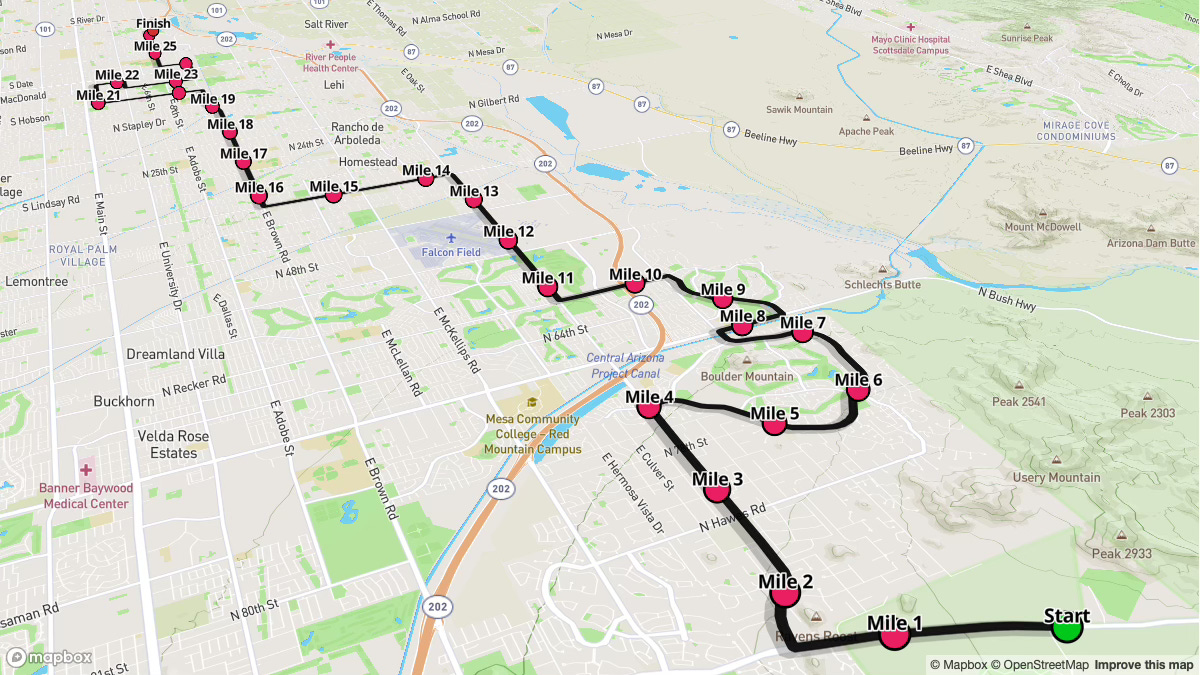
While the course boasts a generous net downhill profile that can encourage faster paces, don't be deceived by the overall descent. The route presents strategic challenges, including a significant climb starting around Mile 4-5, followed by rolling terrain before settling into gentler descents toward downtown Mesa. This varied topography demands both mental and physical preparation, particularly for runners unable to preview the course beforehand.
Key Stats
Event Date: February 8, 2025
Event Type: Road Marathon
Course Length: 26.2 miles
Course Type: Point to Point
TrailScore: 40.24
Road Marathon Rating: Easy
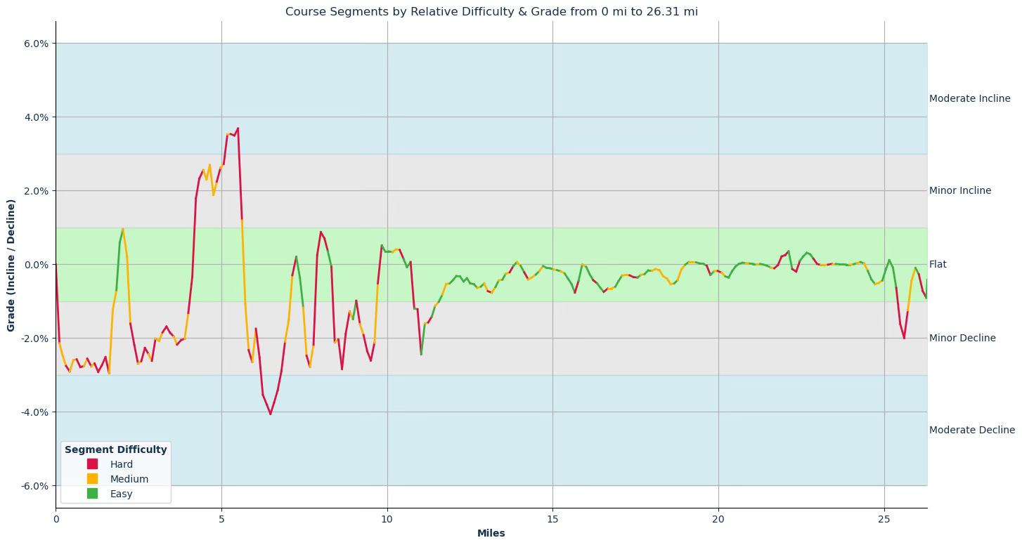
Total Ascent: 265.26 feet
Total Descent: 1129.43 feet
Longest Uphill: 1.50 miles at an average grade of 2.60%, starting at 4.22 miles
Longest Downhill: 5.08 miles at an average grade of -0.32%, starting at 14.03 miles
Steepest Uphill: 1.50 miles at an average grade of 2.60%, starting at 4.22 miles
Steepest Downhill: 1.52 miles at an average grade of -2.56%, starting at 5.74 miles
Grade Distribution:
Flat: 64.6%
Minor Decline: 27.6%
Minor Incline: 4.1%
Moderate Decline: 2.1%
Moderate Incline: 1.6%
Course Briefing
Miles 0-4 (Fast Start Down Usery Pass)
Overview
Starting at 6:30 AM, runners should be prepared to run this first section under lights and through pre-dawn light with sunrise coming at 7:15 AM. These opening miles are consistently downhill (around -2.5%), allowing for early momentum but requiring caution to prevent overexertion in the dark.


Key Challenges
Reduced visibility demands careful attention to footing
Potentially too-fast pacing on the early descents can strain leg muscles
Shifting from the steeper Usery Pass descent to flatter terrain by around Mile 2 and then back to a moderate decline for the remainder of the segment
Aid Stations
Mile 3: Gatorade, Water, Biofreeze, Restrooms, Medical
Points of Interest
Mile 2.73: First spectator zone at SE/SW corner of Hawes Rd. and E McDowell Rd.
Miles 4-7 (The Ridge Climb and Descent)
Overview
This portion includes the longest and steepest uphill of the course (2.6% for 1.5 miles), starting at about mile 4.22, immediately followed by the steepest downhill section. It’s a prime area to dial in your climbing effort and then carefully handle the subsequent descent.


Key Challenges
Moderating pace on the 1.5-mile climb at an average of a 2.6% grade
Staying controlled on the steep (for the course) downhill that follows
Adjusting rhythm quickly between the climb and descent
Aid Stations
Mile 5: Gu Energy Gels, Gatorade, Water, Biofreeze, Restrooms, Medical
Mile 7: Gatorade, Water, Biofreeze, Restrooms, Medical
Points of Interest
Mile 4.3: Community park spectator zone on N Ridgecrest
Mile 7.3: Harriet Tubman Statue
Mile 7.8: Corner of N Power Rd. and E Thomas Rd. spectator zone
Miles 7-14 (McDowell Road Stretch)
Overview
After the significant elevation changes, the route transitions into steady flats and gentle descents. This is a good segment to lock in on a comfortable marathon pace and manage rising temperatures as the sun comes up.


Key Challenges
Staying mentally engaged along long, straight stretches
Adjusting to flatter terrain after earlier climbs and descents
Monitoring the impact of warmer conditions once daylight arrives
Aid Stations
Mile 9: Gu Energy Gels, Gatorade, Water, Biofreeze, Restrooms, Medical
Mile 11: Fruit, Gatorade, Water, Biofreeze, Restrooms, Medical
Mile 13: Gu Energy Gels, Gatorade, Water, Biofreeze, Restrooms, Medical
Points of Interest
Mile 12: Boeing Company spectator zone
Mile 13.1: WAXIE Sanitary Supply spectator zone
Miles 14-20 (Val Vista to Brown)
Overview
Here, the course becomes significantly flatter, offering the longest stretch of sustained flat terrain. Stay locked into your marathon pace through this section; maintaining mental focus is crucial through this section as it lacks dramatic changes in scenery or grade.


Key Challenges
Less downhill assistance can make pacing feel more challenging
Possible exposure to headwinds on open roads
Maintaining focus when the road is straight and mostly flat
Aid Stations
Mile 15: Gatorade, Water, Biofreeze, Restrooms, Medical
Mile 17: Gu Energy Gels, Gatorade, Water, Biofreeze, Restrooms, Medical
Mile 19: Fruit, Gatorade, Water, Biofreeze, Restrooms, Medical
Points of Interest
Mile 15.7: Corner of N Val Vista Rd. and E Brown Rd. spectator zone
Mile 16.7: Mt. View High School spectator zone
Mile 19.7: Corner of Mesa Dr. and E Brown Rd. spectator zone
Miles 20-26.2 (The Final Push)
Overview
The final segment continues the flat profile, with a subtle downhill in the last mile that can help you maintain pace if your legs are still strong. You’ve handed the elevation changes and the flat, it is time to race the last 10k.


Key Challenges
Approaching the typical “wall” zone where energy can wane
Negotiating multiple turns through downtown Mesa
Taking advantage of the slight downhill at the very end
Aid Stations
Mile 21: Gu Energy Gels, Gatorade, Water, Biofreeze, Restrooms, Medical
Mile 22: Gatorade, Water, Biofreeze, Restrooms, Medical
Mile 23: Gu Energy Gels, Gatorade, Water, Biofreeze, Restrooms, Medical
Mile 24: Gatorade, Water, Biofreeze, Restrooms, Medical
Points of Interest
Mile 21.75: 48 North Robson (Inside the Bungalow) spectator zone
Mile 24: Banner Corporate Center spectator zone
Mile 24.6: Westwood High School spectator zone
Mile 24.0: Sce:dagĭ Mu:val Va'aki historical landmark