


The 2025 Grandma's Marathon Course Guide - Imperial Edition (Miles & Feet)
Thought I'd shaken the wonder and the phantoms of my youth Rainy days on the Great Lakes, walkin' the hills of old Duluth. - Bob Dylan, Something There Is About You

Notes: This guide is based on a Run Ready Certified GPX file, created through a standardized process that combines official course maps, measurement certificates, and other plotting techniques. The official course distance is 26.2 miles, which is the shortest possible route while staying within the course boundaries. The certified GPX file measures the course at 26.26 miles, so distances in the guide are approximate. Additionally, and as shown below, different platforms will calculate different totals from the same set of coordinates.
This is the Imperial Edition (Miles & Feet) of the course guide. The Metric Edition (Kilometers & Meters) is available here.
Course Overview
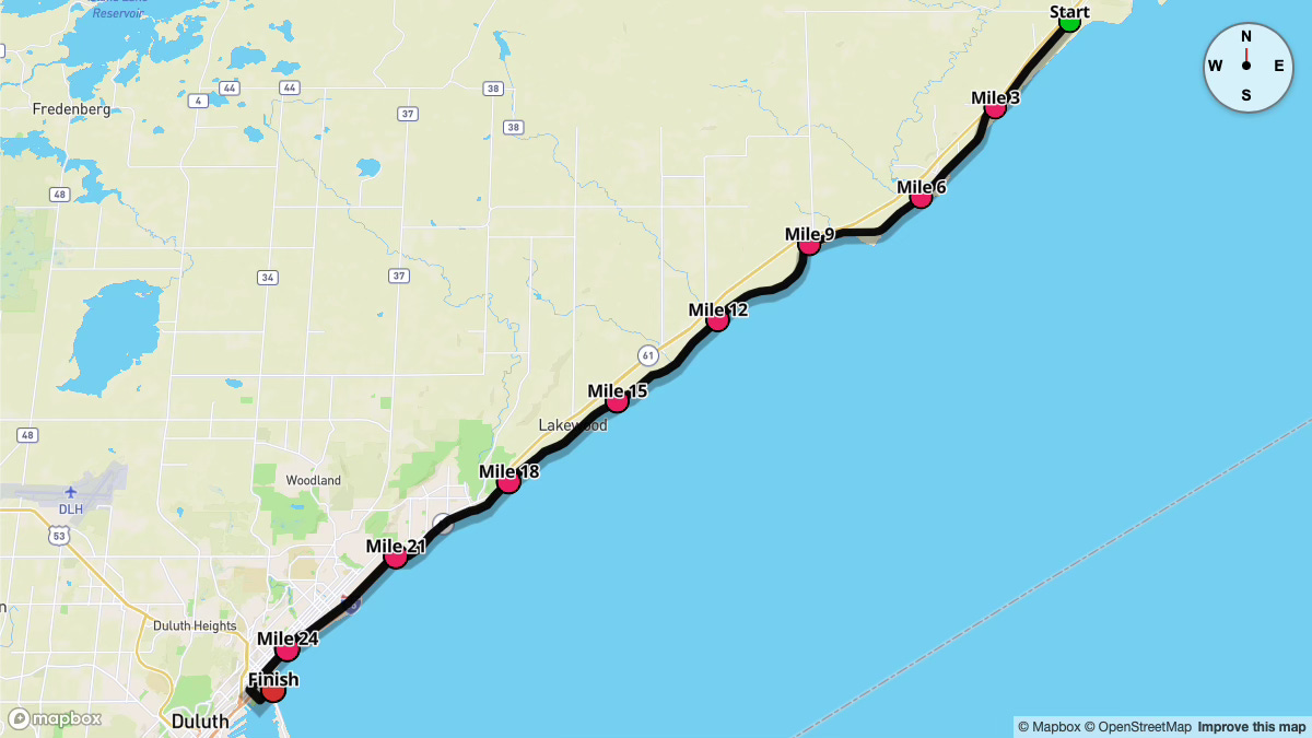
Grandma's Marathon has become one of the most celebrated road races in the Midwest, renowned for its scenic route along Lake Superior and its welcoming community support. Established in 1977, the race begins just outside Two Harbors, MN, and finishes in Duluth's historic Canal Park. The gently rolling terrain follows Scenic Highway 61 before transitioning into city streets, with Lake Superior on your left for most of the way.
The race begins at 7:35 a.m. for Wheelchair & Adaptive divisions, 7:40 a.m. for Men's Elite/Sub-Elite, and 7:45 a.m. for Women's Elite/Sub-Elite and Citizens. Temperatures at the start often hover in the high 50s°F with relatively high humidity. Over the day, highs typically reach the mid-to-upper 60s°F, though weather off the lake can shift quickly.
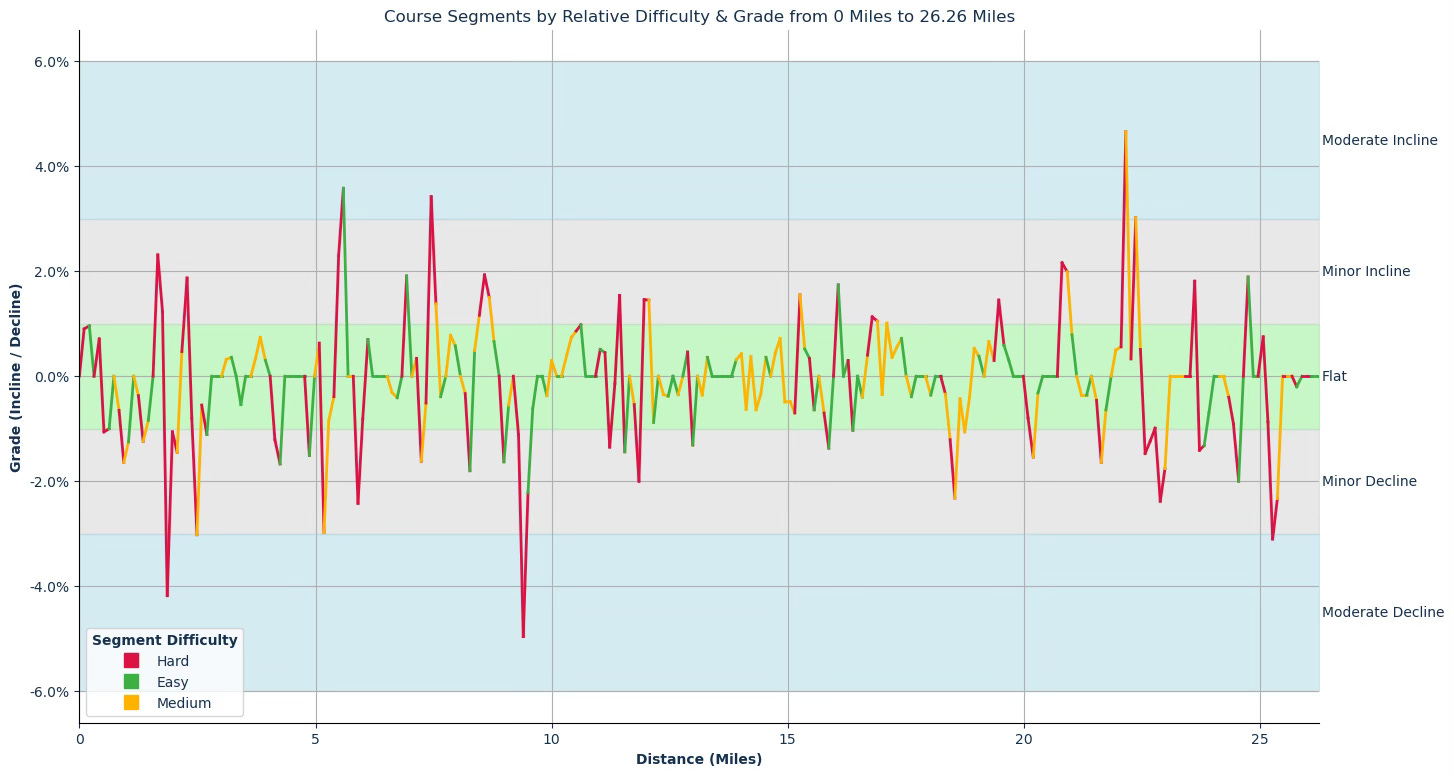
The course features about 437 feet of ascent and 563 feet of descent. Runners will encounter rolling hills—mostly gentle—along Scenic Highway 61. One notable feature is "Lemon Drop Hill" near mile 22, which can feel especially challenging late in the race. Once you crest this landmark, you'll drop down into downtown Duluth, where the energy of the crowds and the draw of Canal Park's finish line will help carry you through the final miles.
Key Stats
Event Date: June 21, 2025
Event Type: Road Marathon
Course Length: 26.2 Miles
Course Type: Point to Point
TrailScore: 36.5
Road Marathon Rating: Easy
Total Ascent: 437.20 feet
Total Descent: 563.42 feet
Longest Uphill:
Starting at Mile 21.95, 0.62 miles at an average grade of 1.59%
Longest Downhill:
Starting at Mile 18.34, 0.61 miles at an average grade of -0.96%
Steepest Uphill:
Starting at Mile 5.49, 0.20 miles at an average grade of 2.94%
Steepest Downhill:
Starting at Mile 1.87, 0.31 miles at an average grade of -2.23%
Significant Climbs (≥3% grade & ≥0.1 miles):
There are a total of 4 significant climbs on the course.
Significant Descents (≤-3% grade & ≥0.1 miles):
There are a total of 4 significant descents on the course.
Grade Distribution:
Flat: 74.1%
Minor Decline: 14.1%
Minor Incline: 8.6%
Moderate Decline: 1.6%
Moderate Incline: 1.6%
Course Briefing
Miles 0-7 (Starting Near Two Harbors & Settling into Pace)
These opening miles begin on a rural stretch outside Two Harbors and follow Scenic Highway 61, with Lake Superior to the east.
The terrain here is gently rolling, with short descents and mild inclines. Early spectator support can be found at Larsmont (Mile 3) and Knife River (Mile 5), but crowds are somewhat sparse right at the start due to limited access to the route.


Key Challenges
Rolling sections can disrupt rhythm if you push too hard too soon. Focus on a controlled effort in the early miles.
Two moderate descents appear around miles 1.8 and 2.4. They are short but have a steeper pitch, so avoid over-striding to spare your quads.
Significant Climbs (≥3% grade & ≥0.1 miles)
Climb #1: Mile 5.49 to 5.59, 0.10 mi, avg grade 3.58%, total gain 19.1 ft
Significant Descents (≤-3% grade & ≥0.1 miles)
Descent #1: Mile 1.76 to 1.86, 0.10 mi, avg grade -4.18%, total drop 22.9 ft
Descent #2: Mile 2.38 to 2.49, 0.10 mi, avg grade -3.02%, total drop 16.6 ft
Aid Stations
Mile 3: Water, Powerade Ion4
Mile 5: Water, Powerade Ion4
Mile 7: Water, Powerade Ion4
Points of Interest
Larsmont (Mile 3): Early viewing area for spectators, though traffic can be busy.
Knife River (Mile 5): Popular spot for supporters; also close to a short trail along the river.
Buchanan Historical Marker (~Mile 6.6): A small but interesting historical site near the roadway.
Miles 7-14 (Cruising Along Lake Superior’s North Shore)
Continuing on Scenic Highway 61, you'll stay close to Lake Superior and enjoy consistently scenic views. This section trends gently downhill overall, though there are small hills that require attention.
You'll pass through spots like the SS Robert Wallace site (~Mile 8.9) and other local curiosities.
The terrain remains manageable, with one short uphill that can sneak up on you just after Mile 7.


Key Challenges
Climb #2 around Mile 7.3, though short, arrives early in this section.
Descent #3 near Mile 9.3 deserves attention; exceeding your goal pace could have consequences later on.
Significant Climbs (≥3% grade & ≥0.1 miles)
Climb #2: Mile 7.34 to 7.45, 0.10 mi, avg grade 3.42%, total gain 18.2 ft
Significant Descents (≤-3% grade & ≥0.1 miles)
Descent #3: Mile 9.30 to 9.40, 0.10 mi, avg grade -4.96%, total drop 26.4 ft
Aid Stations
Mile 9: Water, Powerade Ion4
Mile 11: Water, Powerade Ion4
Mile 13: Water, Powerade Ion4
Points of Interest
SS Robert Wallace (~Mile 8.9): Historic ship site near the shore.
Estrada’s Metal Art (~Mile 10.3): Roadside attraction showcasing unique metal sculptures.
Schmidt Creek Overlook (~Mile 11.2): A scenic spot offering views of the lake.
Spruce Overlook (~Mile 12.9): Another pullout with lake vistas.
McQuade Harbor (Mile 13): A popular spectator location with ample parking.
Miles 14-20 (Approaching Duluth & Suburban Transition)
After Mile 14, the course transitions into more suburban areas, signaling your approach to Duluth.
You'll pass landmarks like Brighton Beach Park (~Mile 14.5) and the Lester River region (Mile 19). The terrain continues to roll gently.
Notably, the longest continuous downhill begins around Mile 18.34. Though modest at -0.96% average grade, this gentle descent helps you find rhythm heading into the city.
Crowds thicken as you near Duluth, offering a welcome mental boost.


Key Challenges
Rolling terrain in this section can break momentum if you’re not pacing efficiently.
Mental fatigue may emerge around mile 19. Keep fueling and focusing as you close in on the final 10K.
Significant Climbs (≥3% grade & ≥0.1 miles)
None in this Section
Significant Descents (≤-3% grade & ≥0.1 miles)
None in this Section
Aid Stations
Mile 15: Water, Powerade Ion4
Mile 17: Water, Powerade Ion4
Mile 19: Fresh Fruit, Water, Powerade Ion4
Mile 20: Water, Powerade Ion4
Points of Interest
Brighton Beach Park (~Mile 14.5): Lakeside park that hints you’re nearing Duluth.
Lester River (Mile 19): A lively spectator zone and a tangible sign of entering the city.
London Road in Lakeside (Miles 19-21): Known for energetic crowds, yard parties, and music.
Miles 20-Finish (Lemon Drop Hill & Into Downtown Duluth)
For the start of your final 10k, London Road leads you through Duluth's Lakeside neighborhood. The highlight here is Lemon Drop Hill at Mile 22, which spans the course's longest uphill from 21.95 to 22.57 (average grade 1.59%).
After conquering this climb, the course descends into downtown Duluth, where crowds thicken and the urban environment takes over. Be prepared for a few smaller rises and drops along London Road and Superior Street before making your way to the finish in Canal Park.


Key Challenges
Lemon Drop Hill (Miles 22.06 to 22.37) is a significant challenge late in the race; it demands patience and strong mental focus.
The moderate descent near Mile 25 (Descent #4) can feel jarring on fatigued legs; maintain good form and control.
Significant Climbs (≥3% grade & ≥0.1 miles)
Climb #3: Mile 22.06 to 22.16, 0.10 mi, avg grade 4.66%, total gain 25.6 ft
Climb #4: Mile 22.27 to 22.37, 0.10 mi, avg grade 3.02%, total gain 16.0 ft
Significant Descents (≤-3% grade & ≥0.1 miles)
Descent #4: Mile 25.17 to 25.27, 0.10 mi, avg grade -3.10%, total drop 17.0 ft
Aid Stations
Mile 21: Water, Powerade Ion4
Mile 22: Water, Powerade Ion4
Mile 23: Water, Powerade Ion4
Mile 23.5: Fresh Fruit
Mile 24: Water, Powerade Ion4
Mile 25: Water, Powerade Ion4
Points of Interest
Lemon Drop Hill in Lakeside (Mile 22): A late-race test with plenty of cheering.
Downtown Duluth (Miles 24-25): Packed with spectators, restaurants, and downtown energy.
Duluth Rose Garden (~Mile 23.4): Picturesque garden near the lakefront.
Fond-du-Luth Casino (~Mile 24.4): A prominent downtown landmark as you close in.
Lake Superior Railroad Museum & North Shore Scenic Railroad (~Mile 25.1): A nod to Duluth’s industrial history.
William A Irvin Museum (~Mile 25.6): A retired ore ship turned museum, just a half mile from the finish.
Canal Park (Finish): The iconic finish line with big crowds and post-race celebrations.
Per your own document Brighton Beach is at about mile 18, not 14.5.
As a long time resident, sometimes participant, and a volunteer when I read that in the race description I knew it was correct.
And added feature at the 18 mile mark is John Herbertz, in costume, distributing candy for the entire race (half marathon, wheelers, marathon). Local legend!