


The 2025 Cocodona 250 Course Guide - Metric Edition (Kilometers & Meters)
I’ll keep running, running toward the sun And I’ll never let it set again - Rob Riccardo, The Calm Within

Note: This is an experimental course guide. I needed a big challenge to test how my systems scaled, and I couldn’t think of something bigger than the Cocodona 250. For additional context, here’s some of the things I was looking to understand with this experiment:
Big Data: Some of the AI models I use to create guides have a strict upper bound on how much data they can process. Cocodona definitely pushed that upper bound.
Metric Content: Since I’ve been publishing guides, I’ve found that many non-US runners struggle with US-based races only publishing content using imperial measures (miles, feet, etc.). This guide isn’t intended to replace the phenomenal content Cocodona’s organizers provide. This is an attempt to make that knowledge more accessible to a global audience. As of now I don’t plan on doing an imperial edition of the guide, but I would if a participant requested it.
Maps: Attempting to tell the story of a 250 mile (410 km) course requires a lot more from maps than a marathon does. I had to significantly enhance my maps for this course, and I really wish Substack supported embedded interactive maps as they are really fun to play with.
Update: The Imperial Edition (Miles & Feet) of this guide is available here.
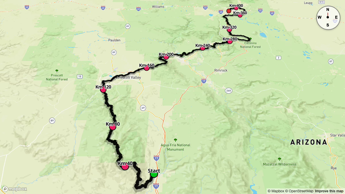
Course Overview
The Cocodona 250 stands as an extraordinary point-to-point ultramarathon, beginning at Deep Canyon Ranch in Black Canyon City and culminating in Flagstaff, Arizona. This iconic race spans over 410 kilometers and is celebrated for its unparalleled diversity, traversing the Sonoran Desert, the Bradshaw Mountains, Verde Valley, Sedona's red rock landscapes, and the high-altitude Coconino Plateau before reaching Flagstaff. Runners embark on a transformative journey across Arizona's diverse and challenging terrain.
The race commences in under twilight at 5:00 AM on Monday, May 5th, allowing participants to navigate the initial desert section during the cooler hours of the day. Competitors must prepare for dramatic temperature variations throughout the event. While the Sonoran Desert and the Verde & Sedona Valleys typically reach daytime highs averaging 29°C, the higher elevations present a stark contrast. The Bradshaw Mountains, Mingus Mountain, Coconino Plateau, and Mount Elden frequently experience nighttime lows between -4°C and 4°C. Participants will encounter both scorching, exposed sections and frigid, potentially windy conditions, particularly during nighttime hours and at higher elevations.

The course features remarkable elevation changes, with over 11,000 meters of ascent and 9,600 meters of descent. The terrain varies dramatically throughout the journey—from technical single-track trails in Black Canyon and the Bradshaw Mountains to jeep roads, paved sections, and cross-country stretches. Athletes must prepare for challenging rocky segments, steep climbs and descents, and continuously changing trail surfaces across this epic 410+ kilometer adventure.
Key Stats
Event Start: May 5, 2025
Event Type: 250+ Mile Ultra Marathon
Course Length: 410.54 km
Course Type: Point to Point
TrailScore: 669.21
250+ Mile Ultra Marathon Rating: Hard
Total Ascent: 11,146.58 m
Total Descent: 9,625.38 m
Longest Uphill:
Starting at KM 164.71, 8.05 km at an average grade of 7.10%
Longest Downhill:
Starting at KM 67.84, 5.34 km at an average grade of -6.09%
Steepest Uphill:
Starting at KM 35.10, 0.50 km at an average grade of 16.64%
Steepest Downhill:
Starting at KM 29.18, 0.17 km at an average grade of -52.75%
Significant Climbs (≥3% grade & ≥0.16 km)
There are a total 248 significant climbs on the course.
Significant Descents (≤-3% grade & ≥0.16 km):
There are a total 194 significant descents on the course.
Grade Distribution:
Flat: 22.5%
Minor Incline: 15.1%
Moderate Incline: 13.1%
Minor Decline: 12.4%
Moderate Decline: 10.0%
Challenging Incline: 8.7%
Challenging Decline: 7.6%
Steep Incline: 5.4%
Steep Decline: 4.0%
Extreme Decline: 0.6%
Extreme Incline: 0.5%
Course Briefing
KM 0-12 (Start to Cottonwood Creek Aid Station)
The race begins at Deep Canyon Ranch, immediately ascending onto the renowned Black Canyon Trail (BCT). Starting before dawn at 5:00 AM, you'll witness the sunrise as you traverse classic Sonoran Desert terrain, distinguished by iconic Saguaro cacti and Ocotillos. The initial section features a climb onto the BCT, followed by rolling doubletrack.
Around KM 5, the course narrows from a wider road to descend into the Slate Creek drainage. Here, you'll encounter your first taste of adventurous terrain with a scramble up a dry creek bed. This segment demands careful footing as you navigate dry waterfall features and loose creek bed material. Exiting the drainage, you'll rejoin the BCT singletrack until the final approach to Cottonwood Creek Aid Station, transitioning to a double-track road for the last kilometer.
This opening 12km section presents a cumulative ascent of approximately 300 meters, preparing you for the varied climbs that lie ahead.


Key Challenges
Early Ascent: The race starts with a sustained climb, immediately testing your legs and establishing the course's demanding elevation profile. Expect to gain approximately 300 meters of elevation within the first 12 kilometers.
Slate Creek Scramble: The off-trail section within the Slate Creek drainage demands focused scrambling and careful foot placement, especially early in the race when energy levels are high and pace may be quicker.
Early Hydration and Desert Heat: Despite the pre-dawn start, the desert can heat up rapidly. The 12km to the first aid station is a significant distance for the race's opening section, making early and proactive hydration crucial.
Significant Climbs (≥3% grade & ≥0.16 km)
Climb #1: KM 0.32 to 1.13, 0.81 km, avg grade 8.37%, total gain 67.9 m
Climb #2: KM 1.96 to 2.12, 0.16 km, avg grade 4.17%, total gain 6.7 m
Climb #3: KM 3.10 to 3.60, 0.50 km, avg grade 4.15%, total gain 20.6 m
Climb #4: KM 3.76 to 3.93, 0.16 km, avg grade 9.03%, total gain 14.7 m
Climb #5: KM 4.09 to 4.25, 0.16 km, avg grade 5.97%, total gain 9.7 m
Climb #6: KM 4.89 to 5.38, 0.49 km, avg grade 4.68%, total gain 22.7 m
Climb #7: KM 5.54 to 6.19, 0.65 km, avg grade 4.96%, total gain 32.1 m
Climb #8: KM 6.35 to 6.83, 0.48 km, avg grade 7.67%, total gain 37.2 m
Climb #9: KM 8.81 to 9.14, 0.33 km, avg grade 4.30%, total gain 14.1 m
Climb #10: KM 9.30 to 9.46, 0.16 km, avg grade 4.18%, total gain 6.9 m
Climb #11: KM 10.77 to 10.94, 0.17 km, avg grade 5.93%, total gain 9.8 m
Climb #12: KM 11.10 to 11.27, 0.17 km, avg grade 4.47%, total gain 7.5 m
Climb #13: KM 11.76 to 13.90, 2.14 km, avg grade 7.86%, total gain 168.1 m
Significant Descents (≤-3% grade & ≥0.16 km)
Descent #1: KM 1.13 to 1.63, 0.49 km, avg grade -5.00%, total drop 24.7 m
Descent #2: KM 2.45 to 2.77, 0.32 km, avg grade -3.64%, total drop 11.7 m
Descent #3: KM 3.93 to 4.09, 0.16 km, avg grade -7.00%, total drop 11.3 m
Descent #4: KM 4.41 to 4.89, 0.48 km, avg grade -12.65%, total drop 61.2 m
Descent #5: KM 7.49 to 7.66, 0.16 km, avg grade -3.07%, total drop 5.1 m
Descent #6: KM 7.82 to 8.15, 0.33 km, avg grade -4.29%, total drop 14.3 m
Descent #7: KM 8.48 to 8.81, 0.33 km, avg grade -5.57%, total drop 18.3 m
Descent #8: KM 9.46 to 9.95, 0.49 km, avg grade -4.96%, total drop 24.2 m
Descent #9: KM 10.12 to 10.28, 0.16 km, avg grade -7.36%, total drop 12.0 m
Descent #10: KM 10.44 to 10.61, 0.17 km, avg grade -5.22%, total drop 8.7 m
Descent #11: KM 11.44 to 11.60, 0.16 km, avg grade -4.58%, total drop 7.4 m
Aid Stations
Cottonwood Creek Aid Station - KM 11.91
Cutoff Time: 5/5/25 9:50 AM
Crew Access: No
Pacer Access: No
Drop Bags: No
Gear Check: No
Sleep Station: No
Medic: No
Special Menu: None
Points of Interest
Black Canyon Trail (Start): Starting on the historic and scenic Black Canyon Trail, the gateway to the Black Canyon National Recreation Trail.
Sonoran Desert Landscape: Immerse yourself in the iconic Sonoran Desert scenery, characterized by towering Saguaro Cactus and unique Ocotillos.
KM 12-52 (Bradshaw Mountain Foothills to Lane Mountain Aid Station)
After leaving Cottonwood Creek Aid Station, the course climbs along a rugged, old mining road and crosses Cottonwood Creek, which typically runs dry during this season. The route continues to the first water station at KM 16.74. The following 35 kilometers to Lane Mountain Aid Station present a formidable challenge. This stretch traverses rocky terrain featuring an unrelenting series of steep, rollercoaster-like ascents and descents. As elevation increases along the ridge, runners are rewarded with sweeping panoramic vistas. However, the technical terrain remains demanding, with loose, ball-bearing gravel that challenges even the surest footing.
At KM 39.59, you'll encounter another water station before making a sharp right turn at KM 46.1 onto the Lane Mountain Trail. This single-track pathway marks a significant transition, climbing approximately 450 meters and offering increasingly dense shade as you ascend into the Ponderosa Pine forests of the Bradshaw Mountains. Anticipate cooler temperatures and magnificent views toward Lake Pleasant as you near the summit. The final kilometer to Lane Mountain Aid Station follows more forgiving double-track terrain. With a cumulative ascent exceeding 1300 meters, this lengthy and grueling section stands as one of the course's most challenging segments.


Key Challenges
Extremely Rocky and Rugged Terrain: This section is notorious for its relentlessly rocky footing. Expect slow progress and the need for constant attention to foot placement to prevent slips and falls.
Sustained Steep Climbs and Descents: Prepare for a seemingly endless series of steep ascents and descents. Even with fresh legs, this segment will significantly test your leg strength and downhill running technique.
Heat Exposure: This is the longest stretch between fully stocked aid stations and is known for intense heat. Ensure you carry ample water and electrolytes, and carefully manage your effort to avoid overheating.
Navigation at KM 46.1: Pay close attention at kilometer 46.1 for the sharp right turn onto the Lane Mountain Trail. Missing this turn can lead you significantly off course.
Significant Climbs (≥3% grade & ≥0.16 km)
Climb #14: KM 15.70 to 15.86, 0.17 km, avg grade 3.88%, total gain 6.5 m
Climb #15: KM 16.52 to 16.68, 0.16 km, avg grade 5.54%, total gain 9.0 m
Climb #16: KM 16.84 to 17.34, 0.49 km, avg grade 7.34%, total gain 36.2 m
Climb #17: KM 17.67 to 17.84, 0.17 km, avg grade 5.30%, total gain 8.9 m
Climb #18: KM 18.17 to 18.50, 0.33 km, avg grade 5.37%, total gain 17.7 m
Climb #19: KM 18.66 to 18.82, 0.16 km, avg grade 8.66%, total gain 14.1 m
Climb #20: KM 18.99 to 19.16, 0.17 km, avg grade 3.39%, total gain 5.7 m
Climb #21: KM 19.32 to 20.63, 1.31 km, avg grade 11.46%, total gain 150.2 m
Climb #22: KM 20.96 to 21.12, 0.16 km, avg grade 4.13%, total gain 6.8 m
Climb #23: KM 21.29 to 21.61, 0.33 km, avg grade 7.69%, total gain 25.2 m
Climb #24: KM 21.77 to 21.94, 0.16 km, avg grade 3.73%, total gain 6.1 m
Climb #25: KM 22.59 to 22.93, 0.33 km, avg grade 10.81%, total gain 36.1 m
Climb #26: KM 23.25 to 24.24, 0.99 km, avg grade 9.71%, total gain 96.0 m
Climb #27: KM 24.40 to 26.23, 1.82 km, avg grade 15.12%, total gain 275.9 m
Climb #28: KM 26.72 to 27.87, 1.15 km, avg grade 13.83%, total gain 159.4 m
Climb #29: KM 29.35 to 29.51, 0.17 km, avg grade 10.12%, total gain 16.7 m
Climb #30: KM 30.00 to 30.33, 0.33 km, avg grade 12.71%, total gain 41.9 m
Climb #31: KM 30.49 to 30.82, 0.33 km, avg grade 4.85%, total gain 15.8 m
Climb #32: KM 30.99 to 31.15, 0.16 km, avg grade 13.03%, total gain 21.4 m
Climb #33: KM 31.48 to 32.30, 0.82 km, avg grade 10.98%, total gain 90.4 m
Climb #34: KM 32.47 to 32.97, 0.50 km, avg grade 19.80%, total gain 98.5 m
Climb #35: KM 33.46 to 33.62, 0.16 km, avg grade 5.49%, total gain 8.9 m
Climb #36: KM 33.96 to 34.12, 0.17 km, avg grade 14.23%, total gain 24.0 m
Climb #37: KM 34.94 to 35.27, 0.33 km, avg grade 23.72%, total gain 78.2 m
Climb #38: KM 36.10 to 37.24, 1.15 km, avg grade 12.14%, total gain 139.3 m
Climb #39: KM 39.56 to 40.05, 0.50 km, avg grade 8.12%, total gain 40.3 m
Climb #40: KM 40.22 to 41.04, 0.83 km, avg grade 11.43%, total gain 94.3 m
Climb #41: KM 41.53 to 42.53, 1.00 km, avg grade 11.12%, total gain 110.8 m
Climb #42: KM 43.18 to 43.67, 0.49 km, avg grade 9.72%, total gain 47.9 m
Climb #43: KM 44.17 to 45.65, 1.48 km, avg grade 8.72%, total gain 128.8 m
Climb #44: KM 45.81 to 47.10, 1.30 km, avg grade 11.00%, total gain 142.7 m
Climb #45: KM 47.26 to 48.89, 1.62 km, avg grade 10.86%, total gain 176.0 m
Climb #46: KM 49.53 to 50.18, 0.65 km, avg grade 15.79%, total gain 102.2 m
Significant Descents (≤-3% grade & ≥0.16 km)
Descent #12: KM 14.06 to 15.70, 1.63 km, avg grade -9.38%, total drop 153.4 m
Descent #13: KM 20.79 to 20.96, 0.16 km, avg grade -7.72%, total drop 12.5 m
Descent #14: KM 21.94 to 22.43, 0.49 km, avg grade -6.48%, total drop 31.7 m
Descent #15: KM 28.37 to 28.69, 0.32 km, avg grade -9.30%, total drop 30.2 m
Descent #16: KM 29.02 to 29.19, 0.17 km, avg grade -52.75%, total drop 88.2 m
Descent #17: KM 29.51 to 30.00, 0.49 km, avg grade -10.50%, total drop 51.2 m
Descent #18: KM 31.15 to 31.48, 0.33 km, avg grade -6.62%, total drop 21.7 m
Descent #19: KM 32.97 to 33.29, 0.33 km, avg grade -13.00%, total drop 42.6 m
Descent #20: KM 34.12 to 34.77, 0.65 km, avg grade -5.99%, total drop 38.8 m
Descent #21: KM 35.44 to 36.10, 0.66 km, avg grade -10.00%, total drop 65.9 m
Descent #22: KM 37.24 to 37.57, 0.33 km, avg grade -8.78%, total drop 29.0 m
Descent #23: KM 37.91 to 39.56, 1.65 km, avg grade -13.01%, total drop 214.7 m
Descent #24: KM 40.05 to 40.22, 0.16 km, avg grade -3.66%, total drop 6.0 m
Descent #25: KM 41.20 to 41.53, 0.33 km, avg grade -14.07%, total drop 46.3 m
Descent #26: KM 42.53 to 43.02, 0.49 km, avg grade -19.12%, total drop 92.9 m
Descent #27: KM 43.67 to 44.00, 0.33 km, avg grade -10.24%, total drop 33.8 m
Descent #28: KM 49.21 to 49.37, 0.16 km, avg grade -15.18%, total drop 24.8 m
Descent #29: KM 50.83 to 51.00, 0.16 km, avg grade -6.15%, total drop 10.1 m
Descent #30: KM 51.16 to 52.14, 0.98 km, avg grade -6.46%, total drop 63.2 m
Aid Stations
Water Station - KM 16.74
Offerings: 1 liter per person only
Water Station - KM 39.59
Offerings: 1 liter per person only
Lane Mtn by UltrAspire Aid Station - KM 52.30
Cutoff Time: 5/5/25 11:20 PM
Crew Access: No
Pacer Access: No
Drop Bags: No
Gear Check: No
Sleep Station: No
Medic: Yes
Special Menu: Watermelon
Points of Interest
Cottonwood Creek: A creek crossing, likely dry, serving as a notable landmark on the course.
Boulder Creek: Another creek crossing, also likely dry, marking your progress through the foothills.
Views from the Ridge: Enjoy incredible panoramic views in all directions as you reach the higher ridges of the Bradshaw Mountains.
Transition to Ponderosa Pines: Experience a noticeable shift in vegetation and temperature as you ascend into the Ponderosa Pine forests, signaling your entry into the Bradshaw Mountains.
Lake Pleasant Views: Catch distant views of Lake Pleasant as you approach Lane Mountain, offering a sense of progress and changing landscapes.
KM 52-59 (Lane Mountain Cruise to Crown King Aid Station)
The segment from Lane Mountain Aid Station to Crown King Aid Station offers a welcome "fairly easy cruise" after the preceding challenging section. The terrain transitions to a smoother double-track dirt road with a predominantly downhill profile. Runners can savor the cooler temperatures and golden light filtering through the Ponderosa Pines during their descent. The aid station sits nestled in the historic mining town of Crown King, home to the Crown King Saloon—recognized as Arizona's oldest continuously operating saloon—which provides a fascinating glimpse into the state's rich history. This brief 7km section flows primarily downhill, dropping approximately 450 meters, offering both physical and mental respite for weary trail runners.


Key Challenges
Maintaining Focus: While this section is physically easier, it's essential to stay mentally engaged. Maintain focus for turns and potential trail hazards, even on smoother terrain.
Foot Care Opportunity: Utilize this gentler section to proactively address any foot issues that may have developed during the rocky terrain before Lane Mountain. Take time for foot care at Crown King.
Significant Climbs (≥3% grade & ≥0.16 km)
Climb #47: KM 52.30 to 53.13, 0.82 km, avg grade 5.42%, total gain 44.7 m
Climb #48: KM 53.62 to 53.94, 0.32 km, avg grade 5.72%, total gain 18.6 m
Significant Descents (≤-3% grade & ≥0.16 km)
Descent #31: KM 53.46 to 53.62, 0.16 km, avg grade -6.72%, total drop 10.9 m
Descent #32: KM 54.10 to 54.59, 0.49 km, avg grade -5.36%, total drop 26.3 m
Descent #33: KM 54.76 to 57.05, 2.29 km, avg grade -8.29%, total drop 189.7 m
Descent #34: KM 57.21 to 58.68, 1.47 km, avg grade -8.04%, total drop 118.3 m
Aid Stations
Crown King by Tailwind Aid Station - KM 58.90
Cutoff Time: 5/5/25 11:55 PM
Crew Access: Yes
Pacer Access: No
Drop Bags: Yes
Gear Check: No
Sleep Station: No
Medic: No
Special Menu: Pulled pork & Black Bean Burgers, Potato/pasta salad, Potato soup, Tailwind slushies
Points of Interest
Crown King Saloon: Experience Arizona's oldest continuously operated saloon, a distinctive historical landmark offering a unique atmosphere.
Crown King Town: Explore the historic mining town of Crown King, complete with a general store and saloon, offering a tangible connection to Arizona's mining heritage.
Drop Bags and Crew Access: Crown King marks the first aid station with drop bag and crew access, providing a significant resupply and support opportunity early in the race.
KM 59-85 (Bradshaw Mountain Traverse to Arrastra Creek Aid Station)
Leaving Crown King Aid Station, the course follows double-track into a steady climb toward Towers Mountain. This section ventures deeper into the Bradshaw Mountains, a range rich with Yavapai history and early 20th-century mining heritage. At KM 63.6, watch carefully for a crucial left turn that begins your descent toward Senator Highway. The route then shifts onto rolling double-track along a ridgeline section of Senator Highway (an unpaved road), providing potential sunset vistas and occasional black bear sightings as you move through this remote wilderness. This approximately 26km section features a net descent and leads to the isolated Arrastra Creek Aid Station.


Key Challenges
Critical Turn at KM 63.6: Be vigilant around kilometer 63.6 to avoid missing the crucial left turn off the main double-track. Missing this turn can lead to significant navigation errors.
Night Gear and Cold Temperatures: As you depart Crown King, a mandatory gear check ensures you are prepared for nighttime conditions in the Bradshaws. Temperatures can drop to around 4°C, requiring appropriate layering.
Remoteness and Self-Sufficiency: This section is lengthy and remote, demanding self-sufficiency. Be prepared to handle potential issues independently, carrying sufficient supplies and gear.
Significant Climbs (≥3% grade & ≥0.16 km)
Climb #49: KM 59.01 to 59.51, 0.49 km, avg grade 8.10%, total gain 40.0 m
Climb #50: KM 59.67 to 63.95, 4.28 km, avg grade 8.04%, total gain 344.3 m
Climb #51: KM 66.22 to 66.87, 0.65 km, avg grade 7.14%, total gain 46.2 m
Climb #52: KM 73.02 to 73.18, 0.16 km, avg grade 10.51%, total gain 17.0 m
Climb #53: KM 74.32 to 74.64, 0.32 km, avg grade 6.41%, total gain 20.8 m
Climb #54: KM 76.10 to 76.42, 0.32 km, avg grade 3.61%, total gain 11.7 m
Climb #55: KM 79.01 to 80.64, 1.63 km, avg grade 6.13%, total gain 99.7 m
Climb #56: KM 80.97 to 81.13, 0.16 km, avg grade 4.88%, total gain 8.0 m
Climb #57: KM 81.62 to 81.78, 0.16 km, avg grade 6.87%, total gain 11.2 m
Significant Descents (≤-3% grade & ≥0.16 km)
Descent #35: KM 63.95 to 66.22, 2.27 km, avg grade -9.58%, total drop 217.3 m
Descent #36: KM 67.35 to 67.51, 0.16 km, avg grade -4.14%, total drop 6.7 m
Descent #37: KM 67.84 to 68.48, 0.65 km, avg grade -7.52%, total drop 48.6 m
Descent #38: KM 68.65 to 70.43, 1.78 km, avg grade -7.09%, total drop 126.2 m
Descent #39: KM 70.59 to 72.86, 2.27 km, avg grade -6.21%, total drop 140.9 m
Descent #40: KM 73.51 to 74.32, 0.81 km, avg grade -4.84%, total drop 39.2 m
Descent #41: KM 74.64 to 74.80, 0.16 km, avg grade -3.22%, total drop 5.2 m
Descent #42: KM 77.40 to 78.04, 0.65 km, avg grade -3.85%, total drop 24.8 m
Descent #43: KM 81.29 to 81.45, 0.16 km, avg grade -3.80%, total drop 6.2 m
Descent #44: KM 82.27 to 83.57, 1.30 km, avg grade -7.96%, total drop 103.7 m
Descent #45: KM 83.73 to 83.89, 0.17 km, avg grade -4.74%, total drop 7.8 m
Descent #46: KM 84.22 to 84.55, 0.33 km, avg grade -7.70%, total drop 25.2 m
Aid Stations
Arrastra Creek Aid Station - KM 85.30
Cutoff Time: 5/6/25 7:00 AM
Crew Access: No
Pacer Access: No
Drop Bags: No
Gear Check: Yes
Sleep Station: No
Medic: No
Special Menu: Rollups (Turkey/Cheese/Hummus/Avocado), Grilled cheese, Potato soup, Spring rolls
Points of Interest
Bradshaw Mountains: Immerse yourself in the heart of the Bradshaw Mountain range, experiencing its rich history and diverse geography.
Towers Mountain: The course ascends towards Towers Mountain, a prominent peak in the Bradshaw range, offering expansive views.
-Senator Highway: Run along a historic route, Senator Highway, enjoying scenic ridgeline running.
Sunset Views: Take in potentially spectacular sunset views over the Bradshaw Mountains as you traverse Senator Highway, weather permitting.
Black Bear Habitat: Be aware of the possibility of black bear sightings in this remote section, adding an element of wilderness to your run.
KM 85-100 (Yankee Doodle Climb to Kamp Kipa Aid Station)
Departing Arrastra Creek Aid Station, the course follows Senator Highway before turning right onto Yankee Doodle Trail. This section features a challenging 5km climb, characterized by rough, steep single-track terrain. Runners should anticipate loose footing and a persistent uphill battle. Near the summit, the trail surface improves, becoming more manageable for running. You'll pass through areas affected by the Crooks Fire, a stark reminder of the course's evolving landscape and the necessary rerouting in 2022.
As you approach one of the highest elevations in the Bradshaws, near Mount Union, the trail eventually opens onto a dirt road. A downhill dirt road section then guides you to Kamp Kipa Aid Station, positioned at the base of a hill within the camp grounds. This segment encompasses a substantial 700-meter climb followed by a descent into the aid station.


Key Challenges
Yankee Doodle Climb: This 5km single-track ascent is characterized as rough, steep, and loose. Prepare for a demanding climb that will likely require hiking and significant effort.
Technical Single-track: The Yankee Doodle Trail is technical, requiring focused footwork and careful navigation on challenging terrain.
Gates: Be prepared to encounter and close multiple gates along the course in this section. Closing gates is essential for maintaining permits and access for future events.
Cold and Dark Conditions: Expect cold and dark conditions, especially if traversing this section during the night. Appropriate night gear and reliable headlamps are essential.
Significant Climbs (≥3% grade & ≥0.16 km)
Climb #58: KM 85.37 to 85.54, 0.16 km, avg grade 3.50%, total gain 5.6 m
Climb #59: KM 85.70 to 85.87, 0.17 km, avg grade 3.64%, total gain 6.0 m
Climb #60: KM 86.03 to 86.52, 0.49 km, avg grade 5.36%, total gain 26.2 m
Climb #61: KM 86.85 to 87.19, 0.33 km, avg grade 6.44%, total gain 21.4 m
Climb #62: KM 87.52 to 88.00, 0.49 km, avg grade 5.46%, total gain 26.7 m
Climb #63: KM 88.49 to 88.66, 0.17 km, avg grade 3.97%, total gain 6.6 m
Climb #64: KM 88.82 to 90.80, 1.98 km, avg grade 7.47%, total gain 147.8 m
Climb #65: KM 91.13 to 91.29, 0.16 km, avg grade 4.44%, total gain 7.3 m
Climb #66: KM 91.46 to 91.62, 0.16 km, avg grade 3.74%, total gain 6.0 m
Climb #67: KM 91.95 to 92.11, 0.17 km, avg grade 3.30%, total gain 5.5 m
Climb #68: KM 92.44 to 93.42, 0.98 km, avg grade 8.98%, total gain 88.3 m
Climb #69: KM 93.75 to 94.56, 0.81 km, avg grade 13.08%, total gain 106.0 m
Climb #70: KM 94.72 to 95.54, 0.82 km, avg grade 10.49%, total gain 86.1 m
Climb #71: KM 95.71 to 96.03, 0.32 km, avg grade 10.83%, total gain 35.1 m
Climb #72: KM 96.20 to 96.68, 0.48 km, avg grade 8.21%, total gain 39.8 m
Climb #73: KM 96.85 to 98.17, 1.32 km, avg grade 7.46%, total gain 98.4 m
Climb #74: KM 98.49 to 98.66, 0.17 km, avg grade 6.25%, total gain 10.5 m
Significant Descents (≤-3% grade & ≥0.16 km)
Descent #47: KM 93.42 to 93.75, 0.33 km, avg grade -6.30%, total drop 20.6 m
Descent #48: KM 95.54 to 95.71, 0.16 km, avg grade -5.93%, total drop 9.7 m
Descent #49: KM 98.17 to 98.33, 0.16 km, avg grade -5.28%, total drop 8.6 m
Descent #50: KM 98.99 to 99.15, 0.17 km, avg grade -4.77%, total drop 7.9 m
Descent #51: KM 99.32 to 99.82, 0.50 km, avg grade -4.04%, total drop 20.2 m
Descent #52: KM 99.98 to 100.31, 0.33 km, avg grade -5.14%, total drop 17.0 m
Aid Stations
Kamp Kipa Aid Station - KM 100.42
Cutoff Time: 5/6/25 2:00 PM
Crew Access: No
Pacer Access: No
Drop Bags: No
Gear Check: No
Sleep Station: Yes - Indoor bunks (Heated space) + limited blankets
Medic: No
Special Menu: Scrambled eggs, egg casserole, tofu, pancakes, bacon
Points of Interest
Senator Highway: Continue on a section of Senator Highway, enjoying its smooth double-track.
Yankee Doodle Trail: Tackle the challenging and scenic single-track climb of Yankee Doodle Trail.
Mount Union Views: As you approach one of the highest points in the Bradshaw Mountains near Mount Union, anticipate expansive views.
Crooks Fire Evidence: Observe areas affected by the 2022 Crooks fire, providing a visible reminder of the landscape's dynamic nature.
Gates: Be prepared to open and close multiple gates along this section, requiring runner cooperation and trail stewardship.
Kamp Kipa: Arrive at Kamp Kipa Aid Station, nestled in a camp setting and located down a hill from the main road.
KM 100-111 (Confusing Roads & Groom Creek Trail to Camp Wamatochick Aid Station)
Leaving Kamp Kipa Aid Station, you'll ascend a short climb before navigating a complex network of intersecting dirt roads. GPS navigation is highly recommended in this section. After 2.5km of winding through these roads and descending, the course reconnects with Senator Highway, providing a pleasant downhill stretch on smooth terrain.
Watch carefully for a crucial right turn at KM 107.5, where you'll leave Senator Highway and join the Groom Creek Trail. Enjoy 3km of beautiful single-track before turning right toward Camp Wamatochick Aid Station. Though relatively brief at 11km, this section demands careful navigation and close attention to trail markers.


Key Challenges
Complex Navigation Leaving Kamp Kipa: The dirt road network immediately after Kamp Kipa Aid Station is intricate with numerous turns. Rely on GPS navigation to stay on the intended course.
Numerous Turns Throughout: This entire section is characterized by frequent turns both on dirt roads and single-track, necessitating constant vigilance to maintain correct routing.
Endangered Species Considerations: The course passes through Mexican Spotted Owl nesting habitat. Runners are asked to be quiet and direct headlamps downwards, especially during nighttime hours, to minimize disturbance to these sensitive species.
Significant Climbs (≥3% grade & ≥0.16 km)
Climb #75: KM 100.31 to 100.64, 0.33 km, avg grade 4.51%, total gain 15.0 m
Climb #76: KM 107.72 to 108.21, 0.49 km, avg grade 7.24%, total gain 35.7 m
Climb #77: KM 110.50 to 110.83, 0.33 km, avg grade 4.90%, total gain 16.2 m
Significant Descents (≤-3% grade & ≥0.16 km)
Descent #54: KM 101.63 to 103.77, 2.14 km, avg grade -9.58%, total drop 205.0 m
Descent #55: KM 104.09 to 104.26, 0.17 km, avg grade -7.05%, total drop 11.8 m
Descent #56: KM 106.40 to 106.56, 0.16 km, avg grade -4.06%, total drop 6.6 m
Descent #57: KM 108.54 to 109.19, 0.65 km, avg grade -5.32%, total drop 34.6 m
Descent #58: KM 109.35 to 110.17, 0.81 km, avg grade -4.41%, total drop 35.8 m
Aid Stations
Camp Wamatochick Aid Station - KM 111.04
Cutoff Time: 5/6/25 4:45 PM
Crew Access: No
Pacer Access: No
Drop Bags: Yes
Gear Check: No
Sleep Station: Yes - Indoor bunk rooms (Heated space)
Medic: No
Special Menu: Burgers, Soup, Pancakes, bacon
Points of Interest
Senator Highway (Again): Enjoy another section of Senator Highway, this time primarily downhill.
Groom Creek Trail: Experience the beauty of Groom Creek Trail, offering amazing single-track running through a scenic creek area.
Mexican Spotted Owl Habitat: Be mindful and respectful as you pass through the nesting habitat of the endangered Mexican Spotted Owl in this section.
KM 111-124 (Flowy Singletrack & Prescott Pavement to Whiskey Row Aid Station)
From Camp Wamatochick Aid Station, the course transitions to a diverse mix of terrain. Initially, it follows a dirt road leading to the Groome Creek trailhead parking lot. Veering left through the parking lot, you'll cross Senator Highway (now paved) and briefly return to single-track trails. A series of turns on residential dirt roads within the Friendly Pines community then guides you back to single-track trails in the Goldwater Lakes area.
Here, you can enjoy approximately 5km of “really nice buffed out, fun, flowy trail.” This section of single-track concludes in a residential neighborhood at Bannon Creek, transitioning to about 4km of pavement. This paved section involves several turns and a descent into Prescott's main square, culminating at the vibrant Whiskey Row Aid Station located at the Grand Highland Hotel. This segment is characterized by varied surfaces and a net descent of around 300 meters into Prescott.


Key Challenges
Navigation in Friendly Pines: The route through the Friendly Pines residential area involves numerous turns on residential dirt roads. Pay close attention to course markings or GPS to navigate correctly.
Pavement Transition: The final 4km into Whiskey Row Aid Station are on pavement. Be prepared for the change in surface, which can feel taxing after extended trail running.
Prescott City Navigation: Be mindful of turns as you navigate the streets of Prescott to reach Whiskey Row Aid Station. Pay attention to urban wayfinding and pedestrian traffic.
Significant Climbs (≥3% grade & ≥0.16 km)
Climb #78: KM 113.43 to 113.59, 0.16 km, avg grade 3.57%, total gain 5.9 m
Climb #79: KM 114.58 to 114.90, 0.33 km, avg grade 5.19%, total gain 17.0 m
Climb #80: KM 116.88 to 117.04, 0.16 km, avg grade 3.00%, total gain 4.9 m
Climb #81: KM 120.99 to 121.32, 0.33 km, avg grade 8.10%, total gain 26.6 m
Significant Descents (≤-3% grade & ≥0.16 km)
Descent #59: KM 111.65 to 111.81, 0.16 km, avg grade -6.59%, total drop 10.6 m
Descent #60: KM 112.29 to 113.27, 0.98 km, avg grade -6.22%, total drop 60.6 m
Descent #61: KM 113.59 to 114.08, 0.49 km, avg grade -5.67%, total drop 27.8 m
Descent #62: KM 114.41 to 114.58, 0.16 km, avg grade -3.45%, total drop 5.6 m
Descent #63: KM 115.40 to 115.56, 0.17 km, avg grade -5.90%, total drop 9.8 m
Descent #64: KM 116.55 to 116.88, 0.33 km, avg grade -7.30%, total drop 24.0 m
Descent #65: KM 117.21 to 118.02, 0.82 km, avg grade -6.17%, total drop 50.5 m
Descent #66: KM 118.19 to 118.68, 0.49 km, avg grade -7.54%, total drop 37.3 m
Descent #67: KM 118.85 to 119.01, 0.17 km, avg grade -3.93%, total drop 6.6 m
Descent #68: KM 119.51 to 119.68, 0.17 km, avg grade -4.35%, total drop 7.3 m
Descent #69: KM 120.17 to 120.33, 0.16 km, avg grade -4.98%, total drop 8.1 m
Descent #70: KM 121.49 to 121.82, 0.33 km, avg grade -4.29%, total drop 14.1 m
Descent #71: KM 122.31 to 122.47, 0.16 km, avg grade -6.40%, total drop 10.5 m
Descent #72: KM 122.64 to 123.45, 0.81 km, avg grade -5.64%, total drop 45.9 m
Descent #73: KM 123.78 to 124.12, 0.33 km, avg grade -6.52%, total drop 21.6 m
Aid Stations
Whiskey Row Aid Station - KM 124.40
Cutoff Time: 5/6/25 10:00 PM
Crew Access: Yes
Pacer Access: Yes
Drop Bags: Yes
Gear Check: Yes
Sleep Station: Yes - Indoor cots (Heated space)
Medic: Yes
Special Menu: Pizza, soup, Oatmeal
Points of Interest
Groome Creek Trailhead: Transition point from dirt road to enjoyable single-track trails.
Goldwater Lakes Area: Enjoy running on “buffed out, flowy single-track trails” in the scenic Goldwater Lakes area.
Whiskey Row, Prescott: Arrive at the historic Whiskey Row in Prescott, the original main square known for its saloons and Wild West history.
Grand Highland Hotel: Whiskey Row Aid Station is conveniently located in the courtyard of the Grand Highland Hotel, offering indoor sleeping in a unique setting.
Prescott - First Capital of Arizona Territory: Run through Prescott, the first capital of the Arizona Territory, adding historical context to your journey.
KM 124-146 (Granite Dells & Peavine Trail to Iron King Aid Station)
Leaving Whiskey Row Aid Station, the course initially traverses Prescott's streets before entering the Watson Woods Preserve. Here, you'll run through the serene Granite Creek riparian area and cross the creek itself. A left turn guides you onto the Peavine Trail, where you'll keep left under a bridge and remain on Watson Lake's western shore. As you navigate through Watson Lake Park parking areas, keep the glistening lake to your right.
Beyond these parking areas, navigation becomes more challenging as you enter the dramatic Granite Dells. This section demands careful attention as you traverse granite slickrock, hop between boulders, and scramble across terrain marked with white dots (heavily marked on race day). Stay close to the lake's edge while navigating this distinctive landscape. After passing beneath the dam outflow at KM 136.8, you'll climb back onto granite formations before rejoining the Peavine Trail.
A 6.5km downhill stretch on crushed granite follows, leading you to Iron King Aid Station situated in a residential area. This approximately 22km section features significantly technical terrain within the captivating Granite Dells.


Key Challenges
Complex Navigation in Granite Dells: Navigating the granite slickrock and boulder hopping section around Watson Lake can be challenging and slower-paced. Stay focused and alert for course markings.
Highly Technical Terrain: The Granite Dells section is exceptionally technical, requiring scrambling and boulder hopping. This terrain will demand significant physical exertion and slow your overall pace.
Watson Lake Park Navigation: Navigating through Watson Lake Park parking areas and re-finding the trail within the park can be somewhat confusing. Pay attention to markings to stay on course within the park.
Significant Climbs (≥3% grade & ≥0.16 km)
Climb #82: KM 125.12 to 125.44, 0.33 km, avg grade 3.10%, total gain 10.1 m
Climb #83: KM 126.92 to 127.25, 0.33 km, avg grade 3.79%, total gain 12.7 m
Climb #84: KM 127.75 to 128.24, 0.49 km, avg grade 5.54%, total gain 27.3 m
Climb #85: KM 128.73 to 128.90, 0.17 km, avg grade 6.50%, total gain 10.9 m
Climb #86: KM 130.89 to 131.05, 0.16 km, avg grade 3.37%, total gain 5.5 m
Climb #87: KM 135.32 to 135.65, 0.33 km, avg grade 3.54%, total gain 11.6 m
Climb #88: KM 136.46 to 136.62, 0.16 km, avg grade 5.16%, total gain 8.4 m
Climb #89: KM 137.11 to 137.27, 0.16 km, avg grade 12.05%, total gain 19.7 m
Climb #90: KM 137.44 to 137.76, 0.32 km, avg grade 6.77%, total gain 21.9 m
Climb #91: KM 137.92 to 138.09, 0.16 km, avg grade 3.20%, total gain 5.2 m
Significant Descents (≤-3% grade & ≥0.16 km)
Descent #74: KM 129.07 to 129.40, 0.33 km, avg grade -6.32%, total drop 21.0 m
Descent #75: KM 129.74 to 130.23, 0.49 km, avg grade -3.88%, total drop 19.1 m
Descent #76: KM 131.05 to 132.20, 1.15 km, avg grade -6.41%, total drop 74.0 m
Descent #77: KM 135.65 to 135.97, 0.32 km, avg grade -5.20%, total drop 16.8 m
Descent #78: KM 136.62 to 137.11, 0.49 km, avg grade -9.19%, total drop 44.7 m
Descent #79: KM 137.27 to 137.44, 0.16 km, avg grade -8.00%, total drop 13.1 m
Descent #80: KM 145.96 to 146.12, 0.16 km, avg grade -4.50%, total drop 7.3 m
Aid Stations
Iron King Aid Station - KM 145.97
Cutoff Time: 5/7/25 3:30 AM
Crew Access: Yes
Pacer Access: Yes
Drop Bags: No
Gear Check: No
Sleep Station: No
Medic: Yes
Special Menu: Mashed potato bar w/ sloppy joe topping, tomato soup, oatmeal
Points of Interest
Watson Woods Preserve: Enter the Watson Woods Preserve, beginning your traverse along Granite Creek.
Granite Creek Riparian Area: Run through a lush riparian zone alongside Granite Creek, offering a contrast to the surrounding terrain.
Granite Dells: Experience the unique and scenic Granite Dells, characterized by distinctive granite slickrock formations and boulder fields.
Watson Lake: Run adjacent to the shores of Watson Lake, keeping the lake to your right as you navigate the Granite Dells section.
Peavine Trail (Downhill): Enjoy a 6.5km section of easy downhill running on the crushed granite surface of the Peavine Trail.
Mingus Mountain Views: As you exit the Granite Dells rock formations, catch views of Mingus Mountain in the distance, marking your next major climb.
KM 146-154 (Flat Ranchlands to Fain Ranch Aid Station)
This relatively short 8km section offers mostly flat terrain, a welcome relief after the technical Granite Dells. The trail crosses Fain Ranch land, a working ranch established in the 1870s that provides a glimpse into Arizona's ranching heritage. You'll use A-Frame ladders to navigate over barbed wire fences when entering and exiting the ranch property. Expect approximately 2.5km of cross-country travel through uneven dirt and grasses. Navigation during this off-trail section may be challenging, making GPS guidance essential. The aid station is situated in the Arizona Downs Racetrack parking lot, a distinctive landmark on the ranchlands.


Key Challenges
Cross-Country Navigation: The final 2.5km cross-country section can be difficult to navigate due to indistinct trails. Rely on your GPS device and pre-loaded course file to maintain the correct route.
A-Frame Ladder Fence Crossings: Several A-Frame ladder fence crossings will slow your pace and require careful negotiation. Be cautious and deliberate when using these structures.
Significant Climbs (≥3% grade & ≥0.16 km)
Climb #92: KM 152.51 to 152.67, 0.16 km, avg grade 4.30%, total gain 7.0 m
Climb #93: KM 152.84 to 153.00, 0.16 km, avg grade 3.66%, total gain 5.9 m
Significant Descents (≤-3% grade & ≥0.16 km)
None
Aid Stations
Fain Ranch by Satisfy Aid Station - KM 154.34
Cutoff Time: 5/7/25 6:00 AM
Crew Access: Yes
Pacer Access: Yes
Drop Bags: Yes
Gear Check: Yes
Sleep Station: No
Medic: Yes
Special Menu: Potatoes/veggies/chicken, french toast, pancakes, cookies
Points of Interest
Fain Ranch: Run through the historic Fain Ranch, a working ranch since the 1870s, experiencing Arizona's ranching heritage firsthand.
Pronghorn Antelope: Keep an eye out for potential sightings of Pronghorn Antelope herds roaming across the ranchlands.
Arizona Downs Racetrack: The Fain Ranch Aid Station is uniquely located at the Arizona Downs Racetrack, providing a distinctive setting.
A-Frame Ladders: Navigate multiple A-Frame ladder crossings over barbed wire fences, characteristic features of ranchland travel in this section.
KM 154-174 (Black Hills Ascent to Mingus Mountain Camp Aid Station)
This 20km section presents a formidable challenge, featuring a long, sustained climb into the Black Hills toward Mingus Mountain Camp Aid Station. Initially, the course winds through cross-country terrain, demanding vigilant navigation. After clearing the final A-Frame ladder off Fain Ranch land, the route transitions to a wide dirt road that gradually evolves into a single-track trail, improving in quality as you ascend.
The vegetation transforms noticeably from high desert grasslands to pine, juniper, and pinon forests as elevation increases. Prepare for a demanding 3km switchback climb to reach Mingus Mountain Camp Aid Station, which offers the comfort of a heated indoor space with showers and bunk rooms. This significant ascent involves gaining over 700 meters in elevation, representing one of the race's major climbing challenges.


Key Challenges
Continued Cross-Country Travel: The initial cross-country section persists, requiring careful navigation and attention to the course.
Long, Sustained 8km Climb: This section includes a relentless 8km climb up Mingus Mountain, significantly testing your uphill endurance and mental fortitude in the later stages of the race.
Temperature Swings: Be prepared for a substantial temperature drop as you ascend from the Prescott Valley floor to the higher elevations of Mingus Mountain. This is especially critical if you arrive at night, where temperatures can plummet.
Gates Along the Course: Expect several gates to open and close along the course in this section. Remember to close each gate to maintain permits and access for future events.
Significant Climbs (≥3% grade & ≥0.16 km)
Climb #94: KM 157.55 to 157.71, 0.16 km, avg grade 4.17%, total gain 6.8 m
Climb #95: KM 157.87 to 158.20, 0.33 km, avg grade 3.64%, total gain 11.9 m
Climb #96: KM 158.85 to 159.01, 0.16 km, avg grade 3.01%, total gain 4.9 m
Climb #97: KM 159.66 to 159.98, 0.32 km, avg grade 3.20%, total gain 10.3 m
Climb #98: KM 160.15 to 160.31, 0.16 km, avg grade 3.42%, total gain 5.5 m
Climb #99: KM 160.63 to 160.96, 0.32 km, avg grade 3.44%, total gain 11.2 m
Climb #100: KM 161.12 to 161.44, 0.32 km, avg grade 3.23%, total gain 10.4 m
Climb #101: KM 161.61 to 161.93, 0.32 km, avg grade 4.04%, total gain 13.1 m
Climb #102: KM 162.26 to 162.42, 0.16 km, avg grade 3.74%, total gain 6.1 m
Climb #103: KM 162.91 to 163.24, 0.33 km, avg grade 6.58%, total gain 21.8 m
Climb #104: KM 163.41 to 163.57, 0.16 km, avg grade 5.26%, total gain 8.5 m
Climb #105: KM 163.73 to 163.89, 0.16 km, avg grade 5.09%, total gain 8.2 m
Climb #106: KM 164.54 to 164.71, 0.16 km, avg grade 3.64%, total gain 5.9 m
Climb #107: KM 165.04 to 165.20, 0.16 km, avg grade 5.90%, total gain 9.6 m
Climb #108: KM 165.53 to 165.85, 0.32 km, avg grade 4.22%, total gain 13.7 m
Climb #109: KM 166.01 to 167.31, 1.30 km, avg grade 3.78%, total gain 49.1 m
Climb #110: KM 167.48 to 167.80, 0.32 km, avg grade 4.34%, total gain 14.1 m
Climb #111: KM 167.96 to 171.60, 3.64 km, avg grade 11.40%, total gain 414.6 m
Climb #112: KM 171.77 to 172.43, 0.66 km, avg grade 4.06%, total gain 26.9 m
Climb #113: KM 172.93 to 173.26, 0.33 km, avg grade 7.25%, total gain 23.8 m
Significant Descents (≤-3% grade & ≥0.16 km)
Descent #81: KM 162.74 to 162.91, 0.16 km, avg grade -7.88%, total drop 12.8 m
Descent #82: KM 164.05 to 164.22, 0.16 km, avg grade -6.37%, total drop 10.3 m
Aid Stations
Mingus Mountain Camp Aid Station - KM 174.29
Cutoff Time: 5/7/25 1:00 PM
Crew Access: Yes
Pacer Access: Yes
Drop Bags: Yes
Gear Check: Yes
Sleep Station: Yes - Indoor bunks (Heated space)
Medic: No
Special Menu: Lasagna, Salad, pasta bake, Bread, Pancakes
Points of Interest
100 Mile Mark: Celebrate reaching the 100-mile milestone early in this challenging section.
Black Hills Ascent: Begin your ascent into the Black Hills, the mountain range separating the Prescott Valley from the Verde Valley.
Vegetation Transition: Observe the changing vegetation as you climb, transitioning from high desert grasslands to pine, juniper, and pinon forests.
Mingus Mountain Views: Enjoy views of the ascending pass and the evolving landscape as you climb Mingus Mountain.
Mingus Mountain Camp: Arrive at Mingus Mountain Camp Aid Station, a significant resupply and rest stop offering heated indoor space, showers, and bunk rooms.
KM 174-202 (Mingus Technical Descent to Jerome Aid Station)
Leaving Mingus Mountain Camp Aid Station, you're immediately greeted with spectacular views across the Verde Valley towards Sedona and Flagstaff. After following the cliff edge for a short distance, the North Mingus Trail veers sharply left, beginning a technical descent. The first kilometer is steep and technical, requiring careful footwork. The trail then eases to a gentler grade on an old roadbed, now eroded to single-track.
After cautiously crossing Hwy 89A, the pine forest transitions to scrub oak and sage, revealing views of the historic Verde Mine and the Verde Valley below. The terrain grows rocky again as you proceed. Eventually, the course guides you past the Verde Mine and into Jerome, a historic mining town. The route winds directly through Jerome, which clings dramatically to the side of the Black Hills, before reaching the aid station. This station offers panoramic views overlooking the Verde Valley, Sedona, and the distant Flagstaff peaks. This section features a substantial descent of approximately 1000 meters, predominantly on technical trails.


Key Challenges
North Mingus Trail Technical Descent: The initial descent on North Mingus Trail is steep and highly technical. Expect to slow your pace significantly and focus intently on foot placement.
Rocky Road Surfaces: Be prepared for rocky road surfaces throughout this section, impacting running efficiency and demanding extra attention to footing.
Jerome Town Navigation & Etiquette: Exercise caution navigating through the town of Jerome. Be mindful of pedestrians and vehicles. Stay on sidewalks, not in the road, as this is a sensitive permit area.
Jerome's Hilly Terrain: Jerome is built on a steep hillside, so expect elevation changes even within the town itself. Be prepared for some climbs and descents even on paved surfaces.
Significant Climbs (≥3% grade & ≥0.16 km)
Climb #114: KM 174.41 to 175.23, 0.82 km, avg grade 6.98%, total gain 57.1 m
Climb #115: KM 179.79 to 179.96, 0.16 km, avg grade 4.00%, total gain 6.5 m
Climb #116: KM 180.28 to 180.44, 0.16 km, avg grade 4.32%, total gain 7.0 m
Climb #117: KM 181.09 to 181.58, 0.49 km, avg grade 7.09%, total gain 34.5 m
Climb #118: KM 182.73 to 183.21, 0.48 km, avg grade 4.70%, total gain 22.8 m
Climb #119: KM 183.37 to 183.70, 0.33 km, avg grade 4.80%, total gain 15.7 m
Climb #120: KM 183.87 to 185.49, 1.63 km, avg grade 8.36%, total gain 136.0 m
Climb #121: KM 186.15 to 186.47, 0.32 km, avg grade 7.98%, total gain 25.8 m
Climb #122: KM 186.80 to 186.96, 0.16 km, avg grade 4.76%, total gain 7.8 m
Climb #123: KM 191.06 to 191.22, 0.16 km, avg grade 6.02%, total gain 9.7 m
Climb #124: KM 192.85 to 193.02, 0.16 km, avg grade 6.17%, total gain 10.1 m
Climb #125: KM 201.22 to 201.38, 0.16 km, avg grade 3.48%, total gain 5.6 m
Climb #126: KM 201.71 to 201.88, 0.16 km, avg grade 5.45%, total gain 8.8 m
Significant Descents (≤-3% grade & ≥0.16 km)
Descent #83: KM 176.21 to 179.63, 3.42 km, avg grade -13.45%, total drop 460.0 m
Descent #84: KM 180.61 to 180.77, 0.16 km, avg grade -8.82%, total drop 14.2 m
Descent #85: KM 180.93 to 181.09, 0.16 km, avg grade -3.88%, total drop 6.3 m
Descent #86: KM 181.58 to 181.91, 0.33 km, avg grade -9.25%, total drop 30.7 m
Descent #87: KM 182.07 to 182.73, 0.65 km, avg grade -8.12%, total drop 53.0 m
Descent #88: KM 185.65 to 185.98, 0.33 km, avg grade -4.50%, total drop 14.8 m
Descent #89: KM 186.47 to 186.80, 0.33 km, avg grade -13.74%, total drop 44.7 m
Descent #90: KM 187.45 to 187.61, 0.16 km, avg grade -4.02%, total drop 6.5 m
Descent #91: KM 187.94 to 188.11, 0.16 km, avg grade -4.02%, total drop 6.6 m
Descent #92: KM 188.76 to 188.93, 0.16 km, avg grade -4.20%, total drop 6.8 m
Descent #93: KM 189.42 to 189.75, 0.33 km, avg grade -3.81%, total drop 12.6 m
Descent #94: KM 190.40 to 190.57, 0.17 km, avg grade -3.34%, total drop 5.6 m
Descent #95: KM 190.90 to 191.06, 0.16 km, avg grade -3.18%, total drop 5.2 m
Descent #96: KM 192.36 to 192.85, 0.49 km, avg grade -5.05%, total drop 24.7 m
Descent #97: KM 193.18 to 193.50, 0.33 km, avg grade -5.00%, total drop 16.3 m
Descent #98: KM 193.67 to 193.83, 0.16 km, avg grade -4.68%, total drop 7.6 m
Descent #99: KM 194.00 to 194.16, 0.16 km, avg grade -8.75%, total drop 14.3 m
Descent #100: KM 194.32 to 195.80, 1.48 km, avg grade -9.36%, total drop 138.3 m
Descent #101: KM 197.11 to 198.75, 1.64 km, avg grade -8.69%, total drop 142.5 m
Descent #102: KM 199.57 to 199.74, 0.16 km, avg grade -5.16%, total drop 8.4 m
Descent #103: KM 199.90 to 200.06, 0.17 km, avg grade -4.07%, total drop 6.8 m
Descent #104: KM 200.23 to 201.06, 0.83 km, avg grade -7.49%, total drop 62.1 m
Descent #105: KM 201.38 to 201.55, 0.17 km, avg grade -3.42%, total drop 5.6 m
Descent #106: KM 201.88 to 202.04, 0.16 km, avg grade -6.64%, total drop 10.7 m
Aid Stations
Jerome Historic State Park Aid Station - KM 201.65
Cutoff Time: 5/7/25 8:30 PM
Crew Access: Yes
Pacer Access: Yes
Drop Bags: No
Gear Check: No
Sleep Station: No
Medic: Yes
Special Menu: Chicken tacos, pancakes
Points of Interest
Mingus Mountain Summit Views: Take in spectacular panoramic views from the summit of Mingus Mountain, encompassing the Verde Valley, Sedona, and Flagstaff.
North Mingus Trail: Experience a technical descent off Mingus Mountain on the North Mingus Trail, challenging your downhill skills.
Verde Mine: Run past the historic Verde Mine, a visually striking and unique feature along the course.
Jerome Historic Mining Town: Explore the historic mining town of Jerome, now a vibrant artist community and tourist destination, steeped in Arizona history.
Sedona Canyons 125 Start Line: Pass the start line for the Sedona Canyons 125 race, a shorter distance event that joins the Cocodona course later in the week.
KM 202-216 (Verde River Crossing to Dead Horse Ranch Aid Station)
This section marks the psychological halfway point of the Cocodona 250 race. Leaving Jerome, you'll descend steeply on a rough dirt road, rapidly dropping about 300 meters in elevation. You'll navigate through gates and private property to reach Bitter Creek Wash, where a faint trail ascends, guiding you through Clarkdale's main square. Beyond Clarkdale, the course transitions to an old railroad grade (now a cinder path) that descends gently alongside the Verde River. A unique underpass beneath the historic Tuzigoot bridge leads to a memorable experience: wading across the knee-deep Verde River. This refreshing water crossing precedes your entry into Dead Horse Ranch State Park and the welcoming Dead Horse Ranch Aid Station. This section features a significant net descent of around 700 meters, primarily concentrated in the initial kilometers leaving Jerome.


Key Challenges
Steep Initial Descent from Jerome: The descent immediately leaving Jerome is very steep and on loose dirt road. Careful and controlled downhill running is essential to manage this section effectively.
Mandatory Verde River Crossing: Wading across the Verde River is a mandatory part of the course. Be prepared to get your feet wet. Plan for sock changes at the Dead Horse Ranch Aid Station to optimize foot comfort.
Potential Verde Valley Heat: Crossing the Verde Valley during daylight hours can be hot, with temperatures potentially reaching 29°C. Be prepared for heat exposure and manage your effort and hydration accordingly.
Significant Climbs (≥3% grade & ≥0.16 km)
Climb #127: KM 211.06 to 211.22, 0.16 km, avg grade 4.80%, total gain 7.8 m
Climb #128: KM 213.83 to 214.00, 0.16 km, avg grade 6.01%, total gain 9.9 m
Climb #129: KM 214.32 to 214.48, 0.16 km, avg grade 4.30%, total gain 7.0 m
Significant Descents (≤-3% grade & ≥0.16 km)
Descent #107: KM 203.19 to 206.15, 2.96 km, avg grade -10.75%, total drop 318.0 m
Aid Stations
Dead Horse Ranch State Park Aid Station - KM 215.65
Cutoff Time: 5/8/25 12:00 AM
Crew Access: Yes
Pacer Access: Yes
Drop Bags: Yes
Gear Check: No
Sleep Station: No - Individual sleeper tent cots (BYO sleeping bag)
Medic: Yes
Special Menu: Burritos, potato soup, oatmeal
Points of Interest
Jerome Historic State Park: Depart from the aid station located at Jerome Historic State Park, immersing yourself in history from the start of this section.
Verde River Crossing: Experience a unique and refreshing wade through the Verde River, a memorable desert oasis.
Tuzigoot Pueblo: Catch views of the ancient Tuzigoot pueblo perched atop cliffs overlooking the Verde River, offering a glimpse into the region's rich past.
Verde River Oasis: Enjoy the magical oasis of the Verde River, a striking contrast to the surrounding desert landscape.
Dead Horse Ranch State Park: Arrive at Dead Horse Ranch State Park Aid Station, a welcoming location within a beautiful state park setting.
KM 216-237 (Raptor Trail to Deer Pass Aid Station)
Departing from Dead Horse Ranch State Park Aid Station, the course quickly transitions onto the Lower Raptor Trail. The initial 6.5km is designated as a "NO PASSING ZONE" to protect the delicate Arizona Primrose habitat. This section of Raptor Trail features challenging, baby-head-sized rocks that require precise footing and may reduce your pace. Once beyond the no-passing zone, you'll turn onto Thumper Trail for an enjoyable, flowing descent toward Lime Kiln Trail. A left turn onto Lime Kiln marks the beginning of an impressive 48km stretch of premium single-track that guides you all the way to Deer Pass Aid Station.
As you advance along Lime Kiln Trail, the red rock panoramas become increasingly magnificent, indicating your approach to Sedona's renowned landscape. Near KM 235, you'll briefly travel on dirt road before navigating a series of quick turns and crossing under Hwy 89A through a pipe culvert, bringing you to Deer Pass Aid Station. This section consists primarily of single-track with approximately 400 meters of net elevation gain, mostly occurring on the Lime Kiln Trail.


Key Challenges
Lower Raptor Trail Rocky Terrain: The Lower Raptor Trail's surface is covered in chunky, baby-head-sized rocks, making it physically demanding and potentially slowing your pace.
No Passing Zone on Raptor Trail: The 6.5km no-passing zone on the Lower Raptor Trail requires patience and courtesy towards fellow runners to protect the sensitive Arizona Primrose habitat.
Footcare Due to Fine Dust: The trails from Dead Horse Ranch to Sedona are known for super fine dust. Pay close attention to foot care in this section to prevent blisters and discomfort from dust accumulation.
Significant Climbs (≥3% grade & ≥0.16 km)
Climb #130: KM 216.27 to 216.43, 0.16 km, avg grade 4.69%, total gain 7.6 m
Climb #131: KM 216.76 to 216.92, 0.16 km, avg grade 3.34%, total gain 5.4 m
Climb #132: KM 217.08 to 217.57, 0.49 km, avg grade 4.34%, total gain 21.3 m
Climb #133: KM 217.89 to 218.06, 0.16 km, avg grade 7.08%, total gain 11.6 m
Climb #134: KM 218.39 to 218.55, 0.16 km, avg grade 8.61%, total gain 13.9 m
Climb #135: KM 218.71 to 219.04, 0.33 km, avg grade 5.57%, total gain 18.2 m
Climb #136: KM 219.36 to 219.85, 0.49 km, avg grade 4.82%, total gain 23.7 m
Climb #137: KM 220.02 to 220.18, 0.16 km, avg grade 3.53%, total gain 5.7 m
Climb #138: KM 222.63 to 222.79, 0.16 km, avg grade 7.96%, total gain 12.9 m
Climb #139: KM 223.94 to 224.42, 0.49 km, avg grade 3.76%, total gain 18.3 m
Climb #140: KM 224.74 to 224.91, 0.16 km, avg grade 3.04%, total gain 5.0 m
Climb #141: KM 225.24 to 225.73, 0.49 km, avg grade 3.67%, total gain 17.9 m
Climb #142: KM 226.55 to 226.71, 0.17 km, avg grade 3.34%, total gain 5.5 m
Climb #143: KM 226.88 to 227.04, 0.16 km, avg grade 4.40%, total gain 7.2 m
Climb #144: KM 227.53 to 227.69, 0.16 km, avg grade 4.86%, total gain 8.0 m
Climb #145: KM 228.18 to 228.51, 0.33 km, avg grade 4.10%, total gain 13.6 m
Climb #146: KM 230.31 to 230.64, 0.33 km, avg grade 4.41%, total gain 14.5 m
Climb #147: KM 231.14 to 231.30, 0.17 km, avg grade 3.78%, total gain 6.3 m
Climb #148: KM 231.63 to 231.96, 0.33 km, avg grade 4.81%, total gain 15.7 m
Climb #149: KM 233.59 to 233.76, 0.16 km, avg grade 3.02%, total gain 4.9 m
Climb #150: KM 234.90 to 235.06, 0.16 km, avg grade 3.79%, total gain 6.2 m
Climb #151: KM 235.22 to 235.55, 0.33 km, avg grade 4.94%, total gain 16.3 m
Climb #152: KM 236.04 to 236.20, 0.16 km, avg grade 4.16%, total gain 6.8 m
Climb #153: KM 236.86 to 237.02, 0.16 km, avg grade 6.33%, total gain 10.2 m
Significant Descents (≤-3% grade & ≥0.16 km)
Descent #108: KM 206.64 to 207.29, 0.65 km, avg grade -7.26%, total drop 46.9 m
Descent #109: KM 207.62 to 207.78, 0.17 km, avg grade -4.48%, total drop 7.5 m
Descent #110: KM 207.95 to 208.43, 0.49 km, avg grade -4.29%, total drop 20.9 m
Descent #111: KM 209.10 to 209.92, 0.83 km, avg grade -5.95%, total drop 49.1 m
Descent #112: KM 210.57 to 210.74, 0.16 km, avg grade -3.68%, total drop 6.0 m
Descent #113: KM 211.22 to 211.39, 0.16 km, avg grade -4.48%, total drop 7.2 m
Descent #114: KM 214.64 to 214.81, 0.16 km, avg grade -6.99%, total drop 11.3 m
Descent #115: KM 221.49 to 221.98, 0.49 km, avg grade -5.12%, total drop 25.1 m
Descent #116: KM 222.14 to 222.47, 0.33 km, avg grade -7.95%, total drop 26.0 m
Descent #117: KM 222.79 to 223.28, 0.49 km, avg grade -5.07%, total drop 24.9 m
Descent #118: KM 223.44 to 223.77, 0.33 km, avg grade -4.39%, total drop 14.5 m
Descent #119: KM 228.02 to 228.18, 0.16 km, avg grade -4.28%, total drop 6.9 m
Descent #120: KM 228.68 to 228.84, 0.16 km, avg grade -5.80%, total drop 9.6 m
Descent #121: KM 232.28 to 232.61, 0.33 km, avg grade -8.78%, total drop 28.8 m
Descent #122: KM 233.76 to 233.92, 0.16 km, avg grade -3.18%, total drop 5.2 m
Descent #123: KM 235.71 to 235.88, 0.17 km, avg grade -3.05%, total drop 5.1 m
Aid Stations
Deer Pass Trailhead Aid Station - KM 236.89
Cutoff Time: 5/8/25 4:45 AM
Crew Access: Yes
Pacer Access: No
Drop Bags: No
Gear Check: No
Sleep Station: No
Medic: Yes
Special Menu: Hot dogs, soup, Turkey/cheese/hummus/avocado sandwiches, Fruit, Pancakes
Points of Interest
Arizona Primrose Habitat (No Passing Zone): Be mindful of the designated no-passing zone on the Lower Raptor Trail, protecting the habitat of the endangered Arizona Primrose plant species.
Lime Kiln Trail Immersion: Begin a long and rewarding stretch on the high-quality single-track Lime Kiln Trail.
Transition to Red Rock Vistas: Witness the gradual but unmistakable transition to the breathtaking red rock scenery that defines Sedona as you progress along Lime Kiln Trail.
KM 237-260 (Sedona Singletrack to Sedona Posse Grounds Aid Station)
This section stands as a highlight, frequently cited as a staff favorite, showcasing "world-class" single-track trails and "mind-boggling" views as you immerse yourself in Sedona's magnificent red rock landscape. Following Lime Kiln Trail, you'll briefly intersect with Deer Pass Road before passing through a gate. Exercise careful attention to navigation for the next 6.5km, as the trail weaves through the terrain and occasionally merges with dirt roads before crossing Red Rock Loop Road and transitioning onto Schuerman Mountain Trail. Proceed east around Red Rock High School, utilizing a conveniently placed water station before reconnecting with single-track trails. Be prepared for numerous trail junctions that demand precise navigation.
The Ridge Trail section presents especially breathtaking "holy cow!" views, particularly of the iconic Cathedral Rock. Just beyond KM 255, a left turn off Bandit Trail guides you onto pavement for a brief stretch leading to Sedona Posse Grounds Aid Station. Remain vigilant of two-way traffic when approaching and departing this aid station. This remarkable segment, spanning approximately 23km, unfolds almost entirely on Sedona's picturesque single-track trails.


Key Challenges
Complex Sedona Trail Navigation: This section involves navigating a network of Sedona trails with numerous junctions and turns. Vigilant navigation using GPS and course markings is crucial to stay on the correct route.
Midday Sedona Heat: Sedona can experience intense heat, especially during midday sun. Be prepared for potentially high temperatures and exposed trails in this section.
Technical Sedona Trails: Sedona's trails, while visually stunning, can be technically challenging with slickrock sections and uneven surfaces. Be ready for varied footing and terrain.
Significant Climbs (≥3% grade & ≥0.16 km)
Climb #154: KM 240.64 to 241.46, 0.82 km, avg grade 6.12%, total gain 50.4 m
Climb #155: KM 241.79 to 241.95, 0.16 km, avg grade 4.33%, total gain 7.1 m
Climb #156: KM 242.45 to 243.10, 0.65 km, avg grade 8.22%, total gain 53.5 m
Climb #157: KM 243.43 to 244.92, 1.49 km, avg grade 10.19%, total gain 151.8 m
Climb #158: KM 245.74 to 246.56, 0.82 km, avg grade 6.19%, total gain 50.7 m
Climb #159: KM 250.78 to 250.95, 0.16 km, avg grade 5.52%, total gain 9.0 m
Climb #160: KM 251.60 to 253.05, 1.46 km, avg grade 7.92%, total gain 115.5 m
Climb #161: KM 254.35 to 254.52, 0.16 km, avg grade 6.14%, total gain 10.0 m
Climb #162: KM 255.49 to 256.15, 0.65 km, avg grade 8.53%, total gain 55.6 m
Climb #163: KM 256.80 to 256.97, 0.16 km, avg grade 3.79%, total gain 6.1 m
Climb #164: KM 259.11 to 259.44, 0.32 km, avg grade 5.78%, total gain 18.7 m
Significant Descents (≤-3% grade & ≥0.16 km)
Descent #124: KM 238.67 to 239.17, 0.50 km, avg grade -5.10%, total drop 25.3 m
Descent #125: KM 239.49 to 239.98, 0.49 km, avg grade -4.06%, total drop 19.7 m
Descent #126: KM 240.31 to 240.64, 0.32 km, avg grade -3.55%, total drop 11.5 m
Descent #127: KM 241.46 to 241.63, 0.17 km, avg grade -6.22%, total drop 10.3 m
Descent #128: KM 241.95 to 242.12, 0.17 km, avg grade -4.10%, total drop 6.9 m
Descent #129: KM 243.10 to 243.26, 0.16 km, avg grade -8.89%, total drop 14.3 m
Descent #130: KM 245.41 to 245.57, 0.16 km, avg grade -4.77%, total drop 7.8 m
Descent #131: KM 246.56 to 247.21, 0.65 km, avg grade -13.60%, total drop 88.7 m
Descent #132: KM 247.37 to 248.67, 1.30 km, avg grade -5.99%, total drop 77.8 m
Descent #133: KM 249.00 to 249.16, 0.16 km, avg grade -5.58%, total drop 9.0 m
Descent #134: KM 249.32 to 249.65, 0.32 km, avg grade -4.49%, total drop 14.6 m
Descent #135: KM 251.27 to 251.60, 0.33 km, avg grade -4.26%, total drop 13.9 m
Descent #136: KM 253.38 to 254.19, 0.81 km, avg grade -7.14%, total drop 58.0 m
Descent #137: KM 256.15 to 256.47, 0.33 km, avg grade -12.68%, total drop 41.6 m
Descent #138: KM 259.76 to 260.09, 0.33 km, avg grade -4.87%, total drop 16.0 m
Aid Stations
Water Station - KM 247.68
Sedona Posse Grounds Aid Station - KM 259.91
Cutoff Time: 5/8/25 12:00 PM
Crew Access: Yes
Pacer Access: Yes
Drop Bags: Yes
Gear Check: Yes
Sleep Station: Yes - Indoor cots (Heated space)
Medic: Yes
Special Menu: Burgers, scrambled eggs, tofu, bacon, pancakes
Points of Interest
Lime Kiln Trail (Continued): Continue to enjoy the world-class single-track of Lime Kiln Trail as it leads you deeper into Sedona.
Deer Pass Road Crossing: Briefly intersect Deer Pass Road as you traverse the Sedona trail network.
Red Rock High School Water Station: A conveniently located water station near Red Rock High School, providing essential hydration.
Cathedral Rock Views: Prepare to be awestruck by stunning views of Cathedral Rock, particularly from the elevated vantage points along the Ridge Trail.
Sedona Posse Grounds Park: Arrive at Sedona Posse Grounds Park Aid Station, offering indoor sleeping and a central location within Sedona.
Immersive Sedona Red Rock Country: Experience full immersion into Sedona's iconic red rock landscape, running amidst some of the most visually striking scenery in the world.
KM 260-284 (Sedona Singletrack Bliss & Schnebly Hill Climb to Foxboro Ranch Aid Station)
This section surpasses the previous one, offering exceptional Sedona single-track trails and stunning panoramic vistas. After departing Posse Grounds Aid Station, you'll briefly backtrack before turning onto Adobe Jack Trailhead and quickly traversing beneath AZ89A through a culvert. Continue along Ranger Road past the Sedona Ranger Station (which serves as the Mingus Traverse 82 Mile Finish Line) and underneath AZ179. Here begins your ascent of Schnebly Hill Road, transitioning to the Huckaby-Schnebly Connector trail.
From this point, you'll immerse yourself in pristine single-track paths including Huckaby, Munds Wagon, and the celebrated Hangover trails. The Hangover Trail stands as a "crown jewel of Sedona single-track," winding around the Painted Dome, Teapot, and Merry Go-Round spires with awe-inspiring scenery and occasional exposure to heights. The route eventually reconnects with Schnebly Hill Road, where you'll find a water station at KM 273.5. Continue your climb up Schnebly Hill Road to reach Foxboro Ranch Aid Station, marking your transition from the Verde Valley to the Coconino Plateau where Ponderosa Pine forests begin to appear. This challenging 24km section involves a substantial elevation gain of over 700 meters as you ascend Schnebly Hill.


Key Challenges
Continued Sedona Navigation: Maintain focus on navigation, as this section also features numerous turns within the Sedona trail network.
Hangover Trail Exposure: Hangover Trail, while visually spectacular, can be intimidating for runners with a fear of heights or those unaccustomed to slickrock traverses and exposed edges.
Schnebly Hill Climb: The climb up Schnebly Hill Road is long and substantial, requiring strategic pacing and potentially the use of trekking poles to manage the sustained ascent.
Dramatic Temperature Swings: Be prepared for a potentially drastic temperature swing, transitioning from daytime heat in Sedona to potentially cold nighttime temperatures as you ascend onto the Coconino Plateau.
Significant Climbs (≥3% grade & ≥0.16 km)
Climb #165: KM 263.71 to 263.87, 0.16 km, avg grade 3.43%, total gain 5.7 m
Climb #166: KM 264.03 to 264.86, 0.83 km, avg grade 6.52%, total gain 53.9 m
Climb #167: KM 265.02 to 265.19, 0.16 km, avg grade 7.44%, total gain 12.0 m
Climb #168: KM 265.35 to 266.00, 0.65 km, avg grade 4.89%, total gain 32.0 m
Climb #169: KM 266.83 to 267.00, 0.17 km, avg grade 6.89%, total gain 11.4 m
Climb #170: KM 267.16 to 267.65, 0.49 km, avg grade 5.42%, total gain 26.5 m
Climb #171: KM 267.81 to 267.98, 0.16 km, avg grade 7.27%, total gain 11.8 m
Climb #172: KM 268.30 to 268.80, 0.49 km, avg grade 7.16%, total gain 35.3 m
Climb #173: KM 269.13 to 269.62, 0.50 km, avg grade 7.49%, total gain 37.1 m
Climb #174: KM 269.79 to 270.28, 0.49 km, avg grade 13.39%, total gain 65.9 m
Climb #175: KM 271.43 to 271.59, 0.17 km, avg grade 6.92%, total gain 11.5 m
Climb #176: KM 272.42 to 272.58, 0.17 km, avg grade 3.43%, total gain 5.7 m
Climb #177: KM 272.75 to 272.91, 0.16 km, avg grade 3.30%, total gain 5.3 m
Climb #178: KM 273.90 to 274.90, 1.00 km, avg grade 9.55%, total gain 95.2 m
Climb #179: KM 275.22 to 277.68, 2.46 km, avg grade 7.38%, total gain 181.7 m
Climb #180: KM 277.84 to 278.66, 0.82 km, avg grade 4.85%, total gain 39.5 m
Climb #181: KM 278.82 to 280.94, 2.12 km, avg grade 5.32%, total gain 112.9 m
Climb #182: KM 281.92 to 282.09, 0.16 km, avg grade 3.72%, total gain 6.1 m
Significant Descents (≤-3% grade & ≥0.16 km)
Descent #139: KM 260.92 to 261.41, 0.49 km, avg grade -3.50%, total drop 17.2 m
Descent #140: KM 261.58 to 262.07, 0.49 km, avg grade -4.30%, total drop 21.1 m
Descent #141: KM 262.24 to 262.40, 0.16 km, avg grade -4.58%, total drop 7.5 m
Descent #142: KM 266.00 to 266.17, 0.17 km, avg grade -7.78%, total drop 13.1 m
Descent #143: KM 266.67 to 266.83, 0.16 km, avg grade -4.53%, total drop 7.5 m
Descent #144: KM 271.76 to 272.08, 0.33 km, avg grade -8.29%, total drop 27.0 m
Descent #145: KM 273.07 to 273.40, 0.33 km, avg grade -7.64%, total drop 25.1 m
Descent #146: KM 273.57 to 273.73, 0.17 km, avg grade -3.83%, total drop 6.3 m
Descent #147: KM 281.11 to 281.43, 0.32 km, avg grade -4.53%, total drop 14.6 m
Descent #148: KM 282.58 to 283.22, 0.65 km, avg grade -6.53%, total drop 42.3 m
Descent #149: KM 283.55 to 283.72, 0.16 km, avg grade -3.25%, total drop 5.3 m
Aid Stations
Water Station - KM 278.09
Foxboro Ranch Aid Station - KM 284.37
Cutoff Time: 5/8/25 9:00 PM
Crew Access: Yes
Pacer Access: **No Pacer Section**
Drop Bags: Yes
Gear Check: No
Sleep Station: No
Medic: Yes
Special Menu: Chili and pasta, Oatmeal
Points of Interest
Adobe Jack Trailhead: Re-enter Sedona's renowned single-track trails via the Adobe Jack Trailhead.
Sedona Ranger Station: Pass by the Sedona Ranger Station, marking the transition from town to wilderness trails.
Tlaquepaque Underpass: Experience a unique underpass beneath AZ179, a notable feature of the course.
Schnebly Hill Road Climb: Embark on the long climb up Schnebly Hill Road, ascending to the Coconino Plateau.
Huckaby-Schnebly Connector Trail: Transition from road to single-track bliss as you join the Huckaby-Schnebly Connector trail.
Huckaby, Munds Wagon, Hangover Trails: Immerse yourself in the world-class Sedona single-track experience on Huckaby, Munds Wagon, and Hangover trails.
Painted Dome, Teapot, and Merry Go-Round Spires: Marvel at the iconic red rock formations of Painted Dome, Teapot, and Merry Go-Round spires, particularly visible from Hangover Trail.
Coconino Plateau Transition: Notice the landscape shift as you transition from the Verde Valley to the Coconino Plateau, marked by the emergence of Ponderosa Pine forests.
Foxboro Ranch Aid Station: Arrive at Foxboro Ranch Aid Station, situated on the Coconino Plateau, signaling a significant change in environment and temperature
KM 284-310 (Coconino Plateau Roads to Munds Park Aid Station)
This section marks the beginning of a pacer-free zone to protect Mexican Spotted Owl nesting habitat; pacers are prohibited between Foxboro Ranch and Munds Park. You've now officially entered the Coconino Plateau, home to the world's largest contiguous Ponderosa Pine Forest. Enjoy long stretches of well-graded dirt roads, providing an ideal opportunity to strengthen your legs and maintain good pace after conquering the demanding Schnebly Hill climb. Navigate under I-17 and attentively follow signage at intersections to remain on the designated route.
The final kilometers guide you into Munds Park, where you'll follow sidewalks beneath I-17 before turning left at the Munds Park Community Church to reach the aid station situated behind the building. This approximately 26km section primarily consists of relatively flat dirt roads, offering a welcome runnable interlude after the technical Sedona trails.


Key Challenges
No Pacers Allowed: Pacers are prohibited in this section to minimize disturbance to the nesting habitat of the Mexican Spotted Owl. Run solo and be mindful of noise levels.
Vehicle and ATV Traffic: Be aware of potential vehicle and ATV traffic on the dirt roads, particularly during daylight hours. Always yield to vehicles, as they have right-of-way.
Maintaining Focus on Dirt Roads: Long stretches of dirt roads can become monotonous and mentally taxing. Maintain focus on your pace and navigation to avoid mental fatigue.
Potential for Cold Night Temperatures: Nighttime temperatures on the Coconino Plateau can be very cold, averaging around 3-4°C. Prepare for potentially freezing conditions, especially if utilizing the sleep station at Munds Park.
Significant Climbs (≥3% grade & ≥0.16 km)
Climb #183: KM 284.38 to 284.54, 0.16 km, avg grade 4.52%, total gain 7.4 m
Climb #184: KM 284.71 to 284.87, 0.17 km, avg grade 3.14%, total gain 5.3 m
Climb #185: KM 285.20 to 285.70, 0.49 km, avg grade 5.04%, total gain 24.9 m
Climb #186: KM 288.15 to 288.31, 0.17 km, avg grade 5.25%, total gain 8.7 m
Climb #187: KM 288.48 to 288.97, 0.49 km, avg grade 4.35%, total gain 21.2 m
Climb #188: KM 289.13 to 289.29, 0.16 km, avg grade 3.22%, total gain 5.2 m
Climb #189: KM 289.95 to 290.11, 0.17 km, avg grade 3.33%, total gain 5.5 m
Climb #190: KM 290.76 to 290.92, 0.16 km, avg grade 3.91%, total gain 6.4 m
Climb #191: KM 292.23 to 292.57, 0.34 km, avg grade 5.02%, total gain 16.8 m
Climb #192: KM 292.73 to 292.90, 0.17 km, avg grade 4.38%, total gain 7.3 m
Climb #193: KM 293.06 to 293.23, 0.17 km, avg grade 3.41%, total gain 5.7 m
Climb #194: KM 294.05 to 294.21, 0.16 km, avg grade 4.74%, total gain 7.8 m
Climb #195: KM 296.02 to 296.35, 0.32 km, avg grade 10.07%, total gain 32.6 m
Climb #196: KM 296.84 to 297.17, 0.33 km, avg grade 7.85%, total gain 25.9 m
Climb #197: KM 297.33 to 297.50, 0.17 km, avg grade 6.96%, total gain 11.6 m
Climb #198: KM 297.99 to 298.15, 0.16 km, avg grade 3.01%, total gain 4.8 m
Climb #199: KM 309.66 to 309.82, 0.16 km, avg grade 7.50%, total gain 12.2 m
Significant Descents (≤-3% grade & ≥0.16 km)
Descent #150: KM 291.25 to 291.74, 0.49 km, avg grade -6.02%, total drop 29.3 m
Descent #151: KM 294.54 to 294.87, 0.33 km, avg grade -4.84%, total drop 16.0 m
Descent #152: KM 298.32 to 298.65, 0.33 km, avg grade -5.52%, total drop 18.3 m
Descent #153: KM 298.98 to 299.98, 1.00 km, avg grade -7.20%, total drop 72.0 m
Descent #154: KM 303.60 to 303.93, 0.33 km, avg grade -4.81%, total drop 15.8 m
Descent #155: KM 305.41 to 307.20, 1.79 km, avg grade -6.48%, total drop 116.1 m
Descent #156: KM 307.53 to 307.69, 0.16 km, avg grade -4.67%, total drop 7.7 m
Descent #157: KM 309.00 to 309.16, 0.16 km, avg grade -4.76%, total drop 7.8 m
Aid Stations
Munds Park Aid Station - KM 309.96
Cutoff Time: 5/9/25 2:45 AM
Crew Access: Yes
Pacer Access: Yes
Drop Bags: Yes
Gear Check: Yes
Sleep Station: Yes - Outdoor tents w/ cots (NOT heated)
Medic: Yes
Special Menu: BLT sandwiches, Tomato soup, eggs, tofu, pancakes
Points of Interest
Coconino Plateau Immersion: Experience running within the vast Coconino Plateau and the world's largest contiguous Ponderosa Pine Forest.
I-17 Underpasses: The course passes under I-17 multiple times in this section, a notable feature of the landscape.
Munds Park Community Church: Arrive at Munds Park Aid Station, located conveniently behind the Munds Park Community Church.
Munds Park Community: Reach the community of Munds Park, offering aid and a potential sleep stop on the Coconino Plateau.
KM 310-330 (Kelly Canyon Trails to Kelly Canyon Aid Station)
Pacers are permitted again as you depart from Munds Park Aid Station. Leaving behind the church, you'll swiftly re-enter the forest, pass through a gate, and continue your journey. Be prepared to encounter additional gates throughout this section. The route follows a series of turns on dirt roads that lead under I-17 and into the Kelly Canyon trails area. This segment features numerous transitions between dirt roads and single-track trails, with four specific locations where the 250-mile route diverges from and later reconnects with the 125-mile course – remain vigilant for distance-specific signage at these critical junctions.
Kelly Canyon trails provide a varied running experience, alternating between soft, cushioned pine needle paths and more technical chunky volcanic rock sections. The long, straight dirt road stretches can be mentally taxing; maintain your concentration to stay on course. Kelly Canyon Aid Station offers basic support only, with no pacers, crew, or drop bags permitted. This 20km section features rolling terrain and diverse trail surfaces.


Key Challenges
Navigation and Route Splits: The numerous turns on and off single-track trails, combined with four route splits and rejoins with the 125-mile course, demand constant attention to distance-specific signage. Navigational errors are easy to make in this section.
Terrain Variety Demands Adaptability: Kelly Canyon trails present a mix of plush pine needle paths and chunky volcanic rock. Be prepared to adapt your footing and running style to these varied surfaces.
Limited Support at Kelly Canyon Aid Station: Kelly Canyon Aid Station is barebones, offering limited support. Ensure you are self-sufficient for this section, as pacers, crew, and drop bags are not allowed.
Potential for Course Deviation on Dirt Roads: Long, straight dirt road sections can induce mental fatigue, increasing the risk of losing focus and veering off course. Pay close attention to your map if feeling disoriented.
Significant Climbs (≥3% grade & ≥0.16 km)
Climb #200: KM 312.62 to 312.78, 0.16 km, avg grade 3.51%, total gain 5.7 m
Climb #201: KM 313.11 to 313.43, 0.33 km, avg grade 5.97%, total gain 19.5 m
Climb #202: KM 314.09 to 314.26, 0.16 km, avg grade 5.84%, total gain 9.6 m
Climb #203: KM 315.08 to 315.73, 0.66 km, avg grade 4.53%, total gain 29.7 m
Climb #204: KM 318.54 to 318.70, 0.17 km, avg grade 3.20%, total gain 5.4 m
Climb #205: KM 318.87 to 319.04, 0.17 km, avg grade 3.45%, total gain 5.8 m
Climb #206: KM 319.20 to 319.37, 0.17 km, avg grade 4.64%, total gain 7.7 m
Climb #207: KM 319.54 to 319.70, 0.16 km, avg grade 4.96%, total gain 8.1 m
Climb #208: KM 319.87 to 320.52, 0.66 km, avg grade 4.88%, total gain 32.1 m
Climb #209: KM 321.18 to 321.51, 0.33 km, avg grade 4.70%, total gain 15.5 m
Climb #210: KM 324.14 to 324.30, 0.17 km, avg grade 5.53%, total gain 9.2 m
Significant Descents (≤-3% grade & ≥0.16 km)
Descent #158: KM 316.72 to 316.88, 0.16 km, avg grade -5.02%, total drop 8.2 m
Descent #159: KM 317.04 to 317.21, 0.17 km, avg grade -3.92%, total drop 6.5 m
Descent #160: KM 322.66 to 323.15, 0.49 km, avg grade -4.17%, total drop 20.6 m
Descent #161: KM 323.81 to 323.97, 0.16 km, avg grade -5.04%, total drop 8.2 m
Descent #162: KM 328.59 to 328.75, 0.16 km, avg grade -3.11%, total drop 5.1 m
Descent #163: KM 329.58 to 329.91, 0.32 km, avg grade -3.88%, total drop 12.6 m
Aid Stations
Kelly Canyon Aid Station** - KM 330.24
Cutoff Time: 5/9/25 8:00 AM
Crew Access: No
Pacer Access: No
Drop Bags: No
Gear Check: No
Sleep Station: No
Medic: Yes
Special Menu: Chicken burritos, grits
Points of Interest
Munds Park Community Church (Departure): Leave Munds Park Aid Station located behind the community church, re-entering the forest.
Gates (Continued): Encounter multiple gates along this section, requiring you to open and close them to respect land access agreements.
Kelly Canyon Trails: Experience the diverse Kelly Canyon trail system, characterized by its mix of plush pine needle trails and chunky volcanic rock sections.
-I-17 Underpasses (Again): The course passes under I-17 once more, a recurring feature of the Coconino Plateau sections.
KM 330-344 (Highland Trail & Hwy 89A Crossing to Fort Tuthill Aid Station)
Departing Kelly Canyon Aid Station, you'll begin on single-track trail before quickly transitioning to a well-graded dirt road (FR700). Watch carefully for distance-specific signage, as the 125-mile route branches away from the 250-mile course shortly after leaving the aid station.
This section continues predominantly on dirt roads, including Old Munds Highway, before reconnecting with the 125-mile route and passing beneath I-17 once more. A quick left-right combination then places you onto the Highland Trail single-track. Highland Trail presents rolling terrain as it winds toward Fort Tuthill. A final right turn takes you off the single-track and onto a dirt road that leads directly into Fort Tuthill Aid Station. This approximately 14km section features diverse terrain and a significant highway crossing.


Key Challenges
Highway 89A Crossing: The Highland Trail intersects with Hwy 89A, a potentially dangerous crossing. Exercise extreme caution as cross-traffic DOES NOT stop for trail users.
Temperature Management: Be prepared for potentially cold temperatures, particularly at night on the Coconino Plateau. Layer appropriately and be ready for temperature fluctuations.
Significant Climbs (≥3% grade & ≥0.16 km)
Climb #211: KM 333.01 to 333.17, 0.16 km, avg grade 3.19%, total gain 5.2 m
Climb #212: KM 333.34 to 333.50, 0.17 km, avg grade 3.08%, total gain 5.1 m
Climb #213: KM 334.80 to 334.97, 0.16 km, avg grade 3.98%, total gain 6.5 m
Climb #214: KM 337.26 to 337.43, 0.17 km, avg grade 3.89%, total gain 6.5 m
Climb #215: KM 340.05 to 340.21, 0.16 km, avg grade 4.59%, total gain 7.5 m
Climb #216: KM 341.84 to 342.33, 0.49 km, avg grade 5.97%, total gain 29.5 m
Significant Descents (≤-3% grade & ≥0.16 km)
Descent #164: KM 331.21 to 331.53, 0.32 km, avg grade -3.81%, total drop 12.3 m
Descent #165: KM 333.99 to 334.80, 0.81 km, avg grade -5.28%, total drop 42.9 m
Descent #166: KM 342.83 to 342.99, 0.16 km, avg grade -3.72%, total drop 6.0 m
Aid Stations
Fort Tuthill Aid Station - KM 343.59
Cutoff Time: 5/9/25 12:45 PM
Crew Access: Yes
Pacer Access: **No Pacer Section**
Drop Bags: Yes (A)
Gear Check: Yes
Sleep Station: Yes - Indoor cots (Heated space)
Medic: No
Special Menu: Pasta, salad, bread, oatmeal. Elden Crest Start – Instant Coffee, oatmeal, fruit, bagels
Points of Interest
Kelly Canyon Trails (Departure): Leave the Kelly Canyon trail system behind as you continue towards Flagstaff.
Old Munds Highway History: Traverse a section of the historic Old Munds Highway, a route with historical significance in the region.
Highland Trail Scenery: Enjoy the rolling single-track of Highland Trail, offering pleasant running through the Ponderosa Pines.
I-17 Underpass (Again): The course passes under I-17 once more, a familiar landmark on the Coconino Plateau.
Highway 89A Crossing (Caution): Exercise extreme caution when crossing Highway 89A, a potentially high-traffic road.
Fort Tuthill Arrival: Reach Fort Tuthill Aid Station, located at the historic Fort Tuthill, originally a National Guard training facility.
Flagstaff Crest 39 Start Line: Note that Fort Tuthill is also the start line for the Flagstaff Crest 39 race, a shorter distance event starting later in the week.
KM 344-370 (Airport Loop & Arizona Trail to Walnut Canyon Aid Station)
This section is another pacer-free zone established to protect Mexican Spotted Owl nesting sites. Pacers are prohibited between Fort Tuthill and Walnut Canyon Aid Station. Departing Fort Tuthill Aid Station alongside runners from the 125-mile and 39-mile events, the course makes several turns northeast out of the park and onto the Soldier Trail. Shortly after, the 125-mile course branches off.
The 250-mile course continues beneath I-17 and then winds through cinder paths surrounding Flagstaff Airport on the Flagstaff Loop Trail. Remain vigilant for numerous turns around the airport perimeter. After crossing Lake Mary Road, the course follows YX Ranch Road before reconnecting with the Flagstaff Loop Trail and entering Skunk Canyon, where the 39-mile course diverges. The 250-mile course proceeds straight toward Fisher Point, providing a spectacular panoramic viewpoint overlooking Walnut Canyon. From Fisher Point, a challenging climb out of Walnut Canyon is followed by a right turn onto the Arizona Trail (AZT).
The subsequent 8km on the AZT features "great single-track, a little technical at times," as it closely hugs the rim of Walnut Canyon. Take all right junctions throughout this section to remain on the designated course. A steep ascent away from the canyon rim then leads to Forest Road trailhead and Walnut Canyon Aid Station. This 26km section showcases a diverse landscape, including urban trails around the airport, breathtaking canyon vistas, and classic Arizona Trail single-track.


Key Challenges
No Pacers Allowed: Pacers are prohibited in this section to minimize impact on Mexican Spotted Owl habitat. Maintain a quieter presence and stay alert.
Airport Navigation Complexity: The numerous turns and junctions around Flagstaff Airport can be confusing. Careful navigation using GPS or course markings is essential to stay on route.
Highway Crossings: Be mindful of traffic when crossing both Pulliam Road and Lake Mary Road. Exercise caution and prioritize safety at these road crossings.
Steep Climb out of Walnut Canyon: Prepare for a steep climb as you ascend out of Walnut Canyon towards the aid station at the Forest Road trailhead.
Technical Arizona Trail Section: The AZT section along the rim of Walnut Canyon is described as "a little technical," requiring focus and attention to foot placement on potentially uneven terrain.
Significant Climbs (≥3% grade & ≥0.16 km)
Climb #217: KM 345.77 to 346.09, 0.32 km, avg grade 3.48%, total gain 11.3 m
Climb #218: KM 347.40 to 347.56, 0.16 km, avg grade 7.43%, total gain 12.1 m
Climb #219: KM 349.20 to 349.70, 0.49 km, avg grade 3.65%, total gain 17.9 m
Climb #220: KM 355.12 to 355.79, 0.66 km, avg grade 9.83%, total gain 65.3 m
Climb #221: KM 355.95 to 356.61, 0.66 km, avg grade 7.73%, total gain 50.8 m
Climb #222: KM 359.40 to 359.56, 0.16 km, avg grade 5.49%, total gain 8.9 m
Climb #223: KM 362.48 to 362.64, 0.16 km, avg grade 3.09%, total gain 5.0 m
Climb #224: KM 366.71 to 367.20, 0.49 km, avg grade 7.85%, total gain 38.1 m
Significant Descents (≤-3% grade & ≥0.16 km)
Descent #168: KM 346.75 to 346.91, 0.16 km, avg grade -3.61%, total drop 5.8 m
Descent #169: KM 347.24 to 347.40, 0.16 km, avg grade -4.01%, total drop 6.5 m
Descent #170: KM 347.56 to 347.89, 0.33 km, avg grade -5.29%, total drop 17.3 m
Descent #171: KM 349.86 to 350.02, 0.16 km, avg grade -6.62%, total drop 10.7 m
Descent #172: KM 350.35 to 350.52, 0.17 km, avg grade -3.45%, total drop 5.8 m
Descent #173: KM 353.32 to 353.98, 0.66 km, avg grade -4.59%, total drop 30.2 m
Descent #174: KM 358.58 to 358.75, 0.17 km, avg grade -3.45%, total drop 5.7 m
Descent #175: KM 360.70 to 360.86, 0.16 km, avg grade -3.05%, total drop 4.9 m
Descent #176: KM 362.00 to 362.16, 0.16 km, avg grade -3.22%, total drop 5.2 m
Descent #177: KM 364.26 to 364.43, 0.16 km, avg grade -5.38%, total drop 8.7 m
Descent #178: KM 365.24 to 365.40, 0.16 km, avg grade -4.64%, total drop 7.5 m
Descent #179: KM 365.73 to 366.22, 0.49 km, avg grade -7.73%, total drop 38.2 m
Descent #180: KM 367.36 to 367.53, 0.16 km, avg grade -6.16%, total drop 10.1 m
Descent #181: KM 368.52 to 368.85, 0.33 km, avg grade -3.82%, total drop 12.5 m
Descent #182: KM 369.50 to 369.67, 0.16 km, avg grade -4.60%, total drop 7.5 m
Aid Stations
Walnut Canyon Aid Station** - KM 369.50
Cutoff Time: 5/9/25 7:45 PM
Crew Access: Yes
Pacer Access: Yes
Drop Bags: Yes
Gear Check: Yes
Sleep Station: No
Medic: Yes
Special Menu: Burritos, Roll-ups (Turkey/cheese/hummus/avo), Potato soup, fruit, Oatmeal
Points of Interest
Fort Tuthill Park (Departure): Leave from Fort Tuthill Aid Station, situated within the park area.
Flagstaff Airport Loop Trail: Run around the perimeter of Flagstaff Airport, following sections of the Flagstaff Loop Trail.
Flagstaff Loop Trail Sections: Experience various sections of the Flagstaff Loop Trail as you navigate around the airport and towards Walnut Canyon.
Skunk Canyon Traverse: The course takes you through Skunk Canyon, adding a natural element to the urban trail sections.
Fisher Point & Walnut Canyon Viewpoint: Reach Fisher Point, a scenic viewpoint offering stunning vistas down into Walnut Canyon and a cool cave feature.
Arizona Trail (AZT) along Walnut Canyon Rim: Run a significant and memorable section of the famed Arizona Trail (AZT), hugging the rim of Walnut Canyon.
Walnut Canyon National Monument Proximity: Arrive at Walnut Canyon Aid Station, located near the entrance to Walnut Canyon National Monument, a place of natural and historical significance.
KM 370-381 (Historic Route 66 & Petroglyphs to Wildcat Hill Aid Station)
Pacers are once again permitted as you depart Walnut Canyon Aid Station. Turn left onto Old Walnut Canyon Road, then quickly right onto double-track. You'll navigate a series of alternating turns on double-track for approximately 4km before crossing under the I-40 culvert. After emerging, turn left onto Historic Route 66 for a brief paved section, then right onto a dirt road, followed by another left back onto the Arizona Trail (AZT). Continue through several intersections, passing the volcanic cinder cones of Wildcat and Sheep Hill.
A left turn takes you off the AZT and onto the Tom Moody Loop Trail, guiding you through the Rio de Flag narrows, past a waterfall, and ancient petroglyphs created by the Northern Sinagua peoples over 1,200 years ago. This culturally significant section exits at the Picture Canyon Trailhead. Complete a short out-and-back section to reach Wildcat Hill Aid Station, located at the Flagstaff Fire Department Training facility. This 11km section features diverse terrain including double-track, pavement, and historically rich trails.


Key Challenges
Navigation on Doubletrack Turns: The initial section with numerous turns on double-track requires attentiveness to course markings to avoid misdirection.
Brief Pavement Section on Historic Route 66: Encounter a short section of pavement running on the iconic Historic Route 66, a change of pace after trail sections.
Respect for Indigenous Lands: This section traverses Indigenous lands. Be mindful and respectful, remembering to offer thanks and acknowledge the ancestral significance of the area.
Significant Climbs (≥3% grade & ≥0.16 km)
Climb #225: KM 370.82 to 370.99, 0.17 km, avg grade 3.80%, total gain 6.4 m
Climb #226: KM 371.15 to 371.32, 0.17 km, avg grade 7.14%, total gain 11.8 m
Climb #227: KM 374.93 to 375.10, 0.17 km, avg grade 3.70%, total gain 6.1 m
Climb #228: KM 377.56 to 378.06, 0.50 km, avg grade 3.72%, total gain 18.5 m
Climb #229: KM 380.01 to 380.17, 0.16 km, avg grade 3.38%, total gain 5.5 m
Significant Descents (≤-3% grade & ≥0.16 km)
Descent #183: KM 376.42 to 376.58, 0.16 km, avg grade -7.84%, total drop 12.7 m
Descent #184: KM 378.39 to 378.55, 0.16 km, avg grade -5.09%, total drop 8.2 m
Descent #185: KM 380.17 to 380.33, 0.16 km, avg grade -5.30%, total drop 8.6 m
Aid Stations
Wildcat Hill Aid Station - KM 380.61
Cutoff Time: 5/9/25 10:45 PM
Crew Access: Yes
Pacer Access: Yes
Drop Bags: No
Gear Check: Yes
Sleep Station: No
Medic: Yes
Special Menu: Burgers, soup, pancakes, Pete's Meats
Points of Interest
Walnut Canyon Road Departure: Begin this section leaving Walnut Canyon Aid Station, continuing your journey towards the finish.
I-40 Culvert Crossing: Pass under I-40 via a culvert, a functional element of the course infrastructure.
Historic Route 66 Experience: Run briefly on historic Route 66, experiencing a small segment of this iconic American highway.
Wildcat and Sheep Hill Cinder Cones: Observe views of Wildcat and Sheep Hill cinder cones, volcanic remnants dotting the Flagstaff landscape.
Arizona Trail (AZT) (Continued): Continue on another section of the Arizona Trail, known for its scenic beauty and challenging terrain.
Tom Moody Loop Trail Exploration: Immerse yourself in the Tom Moody Loop Trail, a scenic loop with cultural and natural points of interest.
Rio de Flag Narrows & Waterfall: Discover the natural beauty of Rio de Flag narrows and a waterfall along the Tom Moody Loop Trail.
Sinagua Petroglyphs Discovery: Encounter ancient Sinagua petroglyphs, providing a tangible connection to the Indigenous history of the area.
Picture Canyon Trailhead Exit: Exit the Tom Moody Loop Trail at the Picture Canyon Trailhead, transitioning towards the final aid stations.
Wildcat Hill Aid Station Arrival: Reach Wildcat Hill Aid Station, located at the Flagstaff Fire Department Training facility, a unique aid station setting.
KM 381-404 (Mount Elden Climb & Descent to Trinity Heights Aid Station)
The penultimate section features the ascent and descent of Mount Elden, a formidable challenge this late in the race. After departing Wildcat Hill Aid Station, you'll reconnect with the AZT and gain an unobstructed view of Mount Elden towering ahead. Navigate under AZ89A and through several intersections before turning onto the New Heart Trail. This well-maintained single-track offers a gentle climb initially. Upon reaching the ridgeline at over 2,700 meters elevation, enjoy a 2.5 km traverse through aspen groves with breathtaking panoramic vistas.
Brace yourself for the extremely steep and technical descent down Elden Lookout Trail—a 3 km plunge with a dramatic 600-meter drop featuring 40 switchbacks and substantial steps. At the bottom of Elden Lookout Trail, turn right onto Forces of Nature Trail to reach the FINAL AID STATION at Trinity Heights. This 23-kilometer section is defined by the challenging ascent and descent of Mount Elden.


Key Challenges
Mount Elden Ascent: The climb up Mount Elden, while runnable in sections, is a substantial ascent, especially late in the race. Prepare for a significant effort to gain over 700 meters of elevation.
Elden Lookout Trail Descent: The descent down Elden Lookout Trail is extremely steep and technical. Expect a 600m drop over 3km with 40 switchbacks and large steps. This descent will be very challenging on fatigued legs and potentially slow your pace considerably.
Navigation on Forces of Nature Trail: Forces of Nature Trail, leading to the final aid station, has numerous social trail junctions, requiring careful navigation to ensure you stay on the correct path.
Extreme Cold & Wind on Mount Elden: Be prepared for very cold conditions on Mount Elden, especially at night. Expect nighttime lows around -4°C and potentially below 0°C wind chill at the summit. Pack layers for very cold and windy conditions.
Significant Climbs (≥3% grade & ≥0.16 km)
Climb #230: KM 381.15 to 381.64, 0.49 km, avg grade 4.52%, total gain 22.1 m
Climb #231: KM 382.13 to 382.29, 0.16 km, avg grade 3.28%, total gain 5.4 m
Climb #232: KM 383.43 to 383.60, 0.17 km, avg grade 3.89%, total gain 6.4 m
Climb #233: KM 384.26 to 384.58, 0.33 km, avg grade 5.92%, total gain 19.5 m
Climb #234: KM 385.08 to 385.24, 0.16 km, avg grade 5.43%, total gain 8.9 m
Climb #235: KM 385.40 to 386.55, 1.14 km, avg grade 5.92%, total gain 67.7 m
Climb #236: KM 387.86 to 388.35, 0.49 km, avg grade 6.59%, total gain 32.6 m
Climb #237: KM 388.84 to 391.64, 2.80 km, avg grade 7.98%, total gain 223.4 m
Climb #238: KM 391.81 to 391.97, 0.16 km, avg grade 8.58%, total gain 14.1 m
Climb #239: KM 392.13 to 394.61, 2.47 km, avg grade 8.34%, total gain 206.2 m
Climb #240: KM 394.93 to 395.42, 0.49 km, avg grade 11.66%, total gain 57.2 m
Climb #241: KM 396.24 to 396.90, 0.66 km, avg grade 10.40%, total gain 68.8 m
Climb #242: KM 401.35 to 401.69, 0.33 km, avg grade 4.59%, total gain 15.4 m
Climb #243: KM 401.85 to 402.18, 0.33 km, avg grade 7.79%, total gain 25.7 m
Climb #244: KM 402.35 to 402.84, 0.49 km, avg grade 4.98%, total gain 24.2 m
Climb #245: KM 403.48 to 403.65, 0.16 km, avg grade 6.38%, total gain 10.4 m
Significant Descents (≤-3% grade & ≥0.16 km)
Descent #186: KM 395.75 to 396.07, 0.32 km, avg grade -6.10%, total drop 19.8 m
Descent #187: KM 396.90 to 400.37, 3.47 km, avg grade -18.93%, total drop 656.4 m
Descent #188: KM 400.53 to 401.03, 0.49 km, avg grade -8.75%, total drop 43.1 m
Descent #189: KM 402.84 to 403.16, 0.32 km, avg grade -6.47%, total drop 20.9 m
Descent #190: KM 403.65 to 403.98, 0.33 km, avg grade -5.10%, total drop 16.7 m
Aid Stations
Trinity Heights Aid Station - KM 404.43
Cutoff Time: 5/10/25 8:15 AM
Crew Access: No
Pacer Access: No
Drop Bags: No
Gear Check: No
Sleep Station: No
Medic: No
Special Menu: Burritos/tacos
Points of Interest
Mount Elden Challenge: Prepare to tackle Mount Elden, the final major climb and descent of the Cocodona 250.
New Heart Trail Ascent: Ascend Mount Elden via the well-constructed and runnable New Heart Trail.
Scenic Ridgeline Run: Enjoy a scenic ridgeline section at high elevation, offering expansive views and aspen groves.
Elden Lookout Trail Technical Descent: Descend the extremely steep and technical Elden Lookout Trail, navigating 40 switchbacks and a significant elevation drop.
Forces of Nature Final Approach: Traverse the Forces of Nature Trail, the final trail section leading to the last aid station.
Trinity Heights Aid Station (The Last): Reach Trinity Heights Aid Station, the final aid station before the finish line, marking the culmination of the major climbs.
KM 404-410 (Pipeline Trail & Buffalo Park to the Finish at Heritage Square)
The final 6km to the finish line! Leaving Trinity Heights Aid Station, follow Pipeline Trail, a wide rocky path with some social trails alongside. After approximately 1km, turn onto Lower Oldham Trail, which leads you into Buffalo Park. With the majestic San Francisco Peaks providing a stunning backdrop and the finish line now within reach, touch the iconic buffalo statue at the park entrance. Turn onto the Switzer Canyon cinder path and cross the intersection to continue west on Forest Avenue. Turn left onto Beaver Street, where you can pick up speed for the final kilometer. Make the celebrated "LEFT ON BIRCH" turn, followed by a right turn into Cocodona Alley. You have arrived at the FINISH LINE in Heritage Square! This final stretch is primarily flat or downhill, allowing for a strong finish into Flagstaff.


Key Challenges
Maintaining Pace to Finish: Even with the finish line in sight, fatigue will be significant after 400+ kilometers. Focus on maintaining your pace and energy levels to finish strong.
Navigation in Buffalo Park: Pipeline Trail features several social trails. Ensure you follow course markings closely to stay on the designated route through Buffalo Park.
Managing Emotions at the Finish: As you approach the finish line after such an immense challenge, manage your emotions and focus on executing a strong and memorable finish.
Significant Climbs (≥3% grade & ≥0.16 km)
Climb #246: KM 404.47 to 404.80, 0.33 km, avg grade 3.13%, total gain 10.3 m
Climb #247: KM 405.78 to 406.11, 0.33 km, avg grade 9.11%, total gain 29.7 m
Climb #248: KM 408.43 to 408.60, 0.17 km, avg grade 4.16%, total gain 6.9 m
Significant Descents (≤-3% grade & ≥0.16 km)
Descent #191: KM 405.12 to 405.45, 0.33 km, avg grade -6.91%, total drop 22.8 m
Descent #192: KM 407.27 to 407.77, 0.50 km, avg grade -5.79%, total drop 28.9 m
Descent #193: KM 408.93 to 409.09, 0.17 km, avg grade -8.62%, total drop 14.3 m
Descent #194: KM 409.59 to 409.76, 0.17 km, avg grade -5.73%, total drop 9.5 m
Aid Stations
None.
Points of Interest
Trinity Heights Aid Station (Departure): Leave the final aid station, marking the last leg of your epic journey.
Pipeline Trail: Begin the final trail section on Pipeline Trail, heading towards Buffalo Park.
Buffalo Park Entry: Run through Buffalo Park, a well-known Flagstaff park marking the final approach to the finish.
Buffalo Statue Landmark: Touch the iconic buffalo statue at the Buffalo Park entrance, a symbolic marker on your final kilometers.
Switzer Canyon Cinder Path: Run on the Switzer Canyon cinder path through Buffalo Park, a soft surface for the last park section.
San Francisco Peaks Backdrop: Enjoy stunning views of the snowcapped San Francisco Peaks behind you as you make your final approach to the finish line at Heritage Square.
Heritage Square - FINISH LINE: Cross the finish line in Heritage Square, Flagstaff, completing the monumental Cocodona 250!