


The 2025 Broken Arrow Skyrace 46k Course Guide - Metric Edition (Kilometers & Meters)
When all are one, and one is all To be a rock and not to roll And she's buying a stairway to Heaven - Led Zeppelin, Stairway to Heaven

Notes: This guide is based on a Run Ready Certified GPX file, created through a standardized process that combines official course maps, measurement certificates, and other plotting techniques. The race website mentions several “official” distances, but it is generally acknowledged to be around 46k as the course changes from year to year based on snow. The certified GPX file measures the course at 44.96 km, so distances in the guide are approximate. Additionally, and as shown below, different platforms will calculate different totals from the same set of coordinates.
This is the Metric Edition (Kilometers & Meters) of the course guide. The Imperial Edition (Miles & Feet) is available here.
Course Overview
Set in Olympic Valley at Palisades Tahoe, the Broken Arrow Skyrace 46k stands among North America's premier mountain loop races. Runners depart from the European arch in the Village (former site of the 1960 Winter Olympic ice rink) to complete two identical 22.7 km laps showcasing the Sierra Crest's high-alpine beauty and rugged terrain.
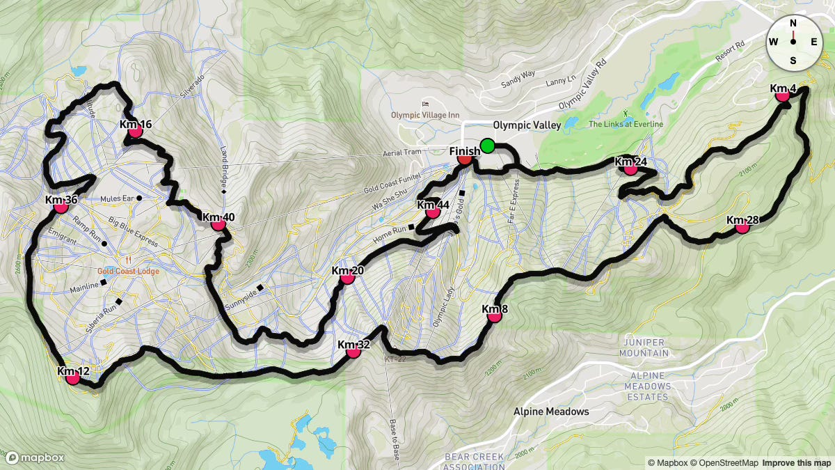
Each lap transitions from smooth two-track and runnable single-track through the Far East parking area onto segments of the legendary Western States Trail. You'll ascend Snow King, traverse the exposed Red Dog Ridge with panoramic Lake Tahoe views, and scramble the Headwall ridgeline to reach the "Stairway to Heaven" ladder at the race's 2,743 m apex. Technical descents through Shirley Basin and Shirley Canyon snowfields challenge your control before returning to the Village.
Race day falls on Saturday, June 21, 2025, with a 7:00 a.m. start; ensuring full daylight as temperatures rise. June 21 historical data at the start line indicates a mean temperature of 13.0°C (range −1.2°C to 21.3°C) with low chance of significant precipitation; 2024 saw dry conditions with temperatures from 6.1°C to 22.8°C.
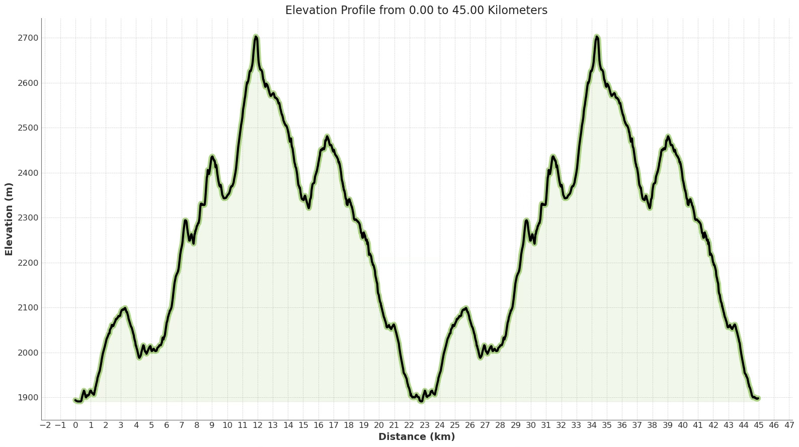
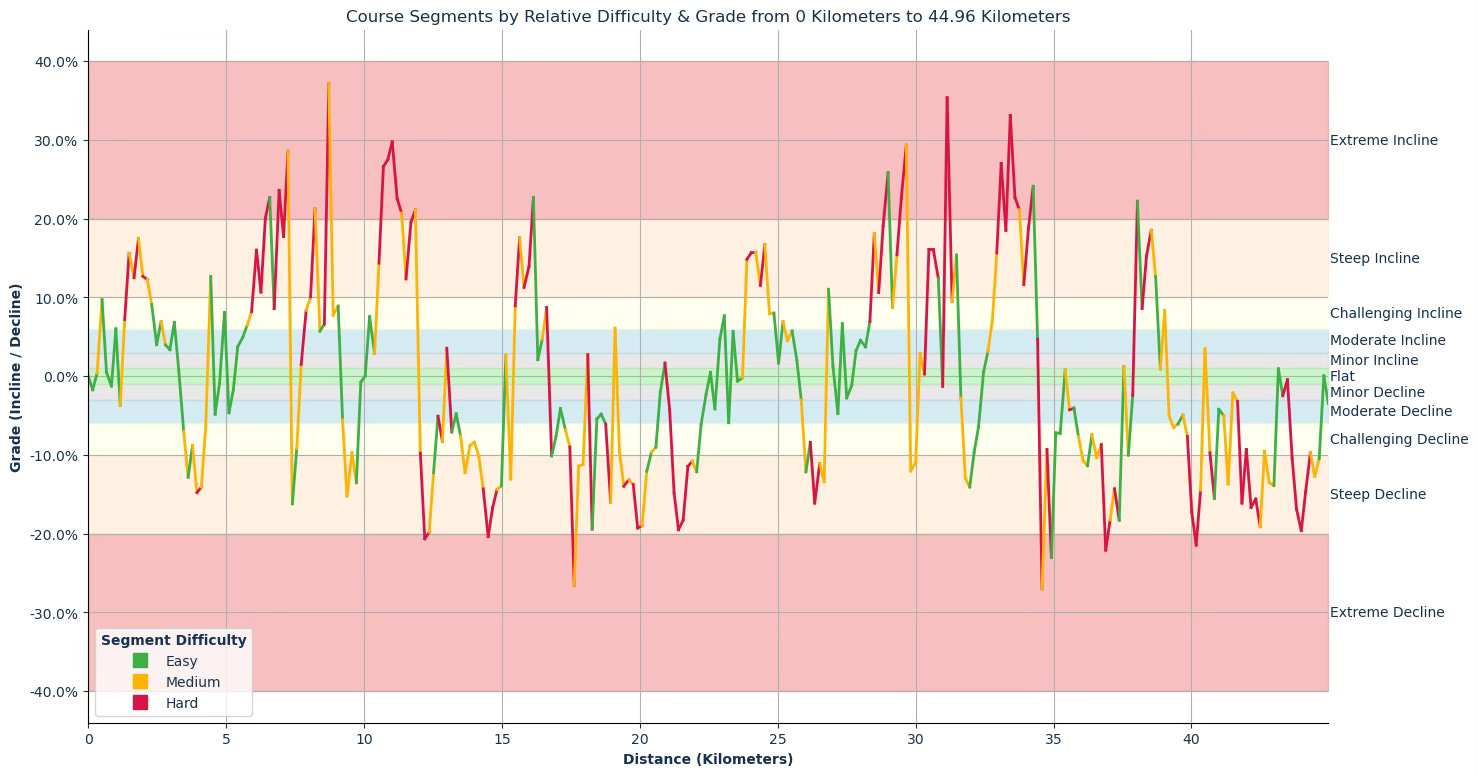
With over 2,673 m of ascent (and nearly equivalent descent) compressed into under 45 km, this course earns its reputation. Anticipate sustained climbs exceeding 10% grade on Snow King and Headwall, technical rocky sections along ridges, and steep, loose descents into Shirley Basin. Conquering this course requires both uphill stamina and precise, controlled downhill technique.
Key Stats
Event Date: Saturday, June 21, 2025
Event Type: Trail Race
Course Length: 46k
Course Type: Loop
TrailScore: 64.08
Trail Race Difficulty Rating: Hard
Total Ascent: 2,673.81 m
Total Descent: 2,672.10 m
Longest Uphill:
Starting at KM 1.32, 2.13 km at an average grade of 8.68 %
Longest Downhill:
Starting at KM 40.66, 2.49 km at an average grade of −11.15 %
Steepest Uphill:
Starting at KM 31.14, 0.50 km at an average grade of 20.12 %
Steepest Downhill:
Starting at KM 34.59, 0.83 km at an average grade of −14.67 %
Significant Climbs (≥3 % grade & ≥0.16 km):
There are a total of 26 significant climbs on the course.
Significant Descents (≤−3 % grade & ≥0.16 km):
There are a total of 27 significant descents on the course.
Grade Distribution:
Steep Decline: 23.1%
Steep Incline: 13.6%
Challenging Decline: 12.8%
Challenging Incline: 10.6%
Extreme Incline: 8.4%
Moderate Decline: 8.1%
Moderate Incline: 6.6%
Flat: 5.9%
Minor Decline: 4.4%
Minor Incline: 4.0%
Extreme Decline: 2.6%
Course Briefing
KM 0.00–8.05 (Village Start to Snow King Aid Station)
Runners begin exiting the Village arch at 7:00 a.m., drop into the Far East parking area, then link onto the Western States Trail. The initial 5 km are smooth two-track and single-track, offering time to settle into a steady rhythm.
Around KM 5, the course turns west and begins climbing ski-area access roads toward Snow King, with the final 2 km featuring the steepest pitches on this stretch.


Key Challenges
Early runnable sections can tempt an overly fast pace; conserve energy for the climb.
Sustained climbing from KM 5.26 to 7.24 reaches up to 28 % grade; expect extended power hiking.
Technical descents between KM 3.29 and 4.27 have sharp pitches and loose sand-and-gravel tread.
Transition from two-track to ski-area single-track demands consistent footing.
Significant Climbs
Climb #1: KM 0.33–0.50, 0.17 km, avg 9.72 %, gain 16.4 m
Climb #2: KM 0.83–1.00, 0.17 km, avg 6.01 %, gain 10.1 m
Climb #3: KM 1.16–3.13, 1.97 km, avg 9.32 %, gain 183.8 m
Climb #4: KM 4.27–4.44, 0.17 km, avg 12.67 %, gain 20.9 m
Climb #5: KM 4.77–4.93, 0.16 km, avg 8.10 %, gain 13.3 m
Climb #6: KM 5.26–7.24, 1.98 km, avg 14.26 %, gain 282.0 m
Significant Descents
Descent #1: KM 1.00–1.16, 0.16 km, avg –3.70 %, drop 6.0 m
Descent #2: KM 3.29–4.27, 0.98 km, avg –10.60 %, drop 104.0 m
Descent #3: KM 4.44–4.60, 0.17 km, avg –4.81 %, drop 8.0 m
Descent #4: KM 4.93–5.10, 0.17 km, avg –4.64 %, drop 7.7 m
Descent #5: KM 7.24–7.57, 0.33 km, avg –12.71 %, drop 41.5 m
Aid Stations
Snow King (KM 8.05): Regular & gluten‑free bread, “regular” food & snacks, Tailwind drink mix, Neversecond 100‑cal gels (three flavors) and fun surprises.
Points of Interest
Far East parking area trailhead (~KM 0.5)
Western States Trail single-track corridor (~KM 0.5–4.5)
Lake Tahoe panoramas on Red Dog Ridge (~KM 7–9)
KM 8.05–17.30 (Snow King to Julia Millon Aid Station)
From Snow King, the trail traverses the narrow Red Dog Ridge, offering panoramic views of Lake Tahoe.
Short, steep pitches (up to 37%) alternate with flatter traverses.
After cresting, you descend into the saddle between KT-22 and Washeshu Peak, then tackle the exposed Headwall scramble; the high point of the race at approximately 2,743 m.
A fast descent and rolling traverse carry you into Shirley Basin before climbing to Julia Millon.


Key Challenges
Ridge pitches at KM 8.56–8.72 reach 37 % grade; deliberate power hiking is essential.
The exposed “Stairway to Heaven” demands surefootedness and concentration under fatigue.
Sustained Headwall climb from KM 10.38 to 11.86 averages over 21 % grade.
Thin air near 2,743 m reduces oxygen; manage effort and breathing accordingly.
Significant Climbs
Climb #7: KM 7.73–9.06, 1.32 km, avg 13.23 %, gain 175.3 m
Climb #8: KM 10.05–10.21, 0.16 km, avg 7.56 %, gain 12.2 m
Climb #9: KM 10.38–11.86, 1.49 km, avg 21.63 %, gain 321.7 m
Climb #10: KM 12.85–13.01, 0.16 km, avg 3.55 %, gain 5.8 m
Climb #11: KM 15.32–16.14, 0.83 km, avg 14.89 %, gain 123.1 m
Climb #12: KM 16.31–16.63, 0.32 km, avg 6.72 %, gain 21.7 m
Significant Descents
Descent #6: KM 9.06–9.72, 0.66 km, avg –10.96 %, drop 72.7 m
Descent #7: KM 11.86–12.85, 0.98 km, avg –12.62 %, drop 124.2 m
Descent #8: KM 13.01–14.99, 1.98 km, avg –11.55 %, drop 228.2 m
Descent #9: KM 15.15–15.32, 0.16 km, avg –13.06 %, drop 21.5 m
Aid Stations
Siberia (KM 12.87): Regular & gluten‑free bread, “regular” food & snacks, Tailwind drink mix, Neversecond 100‑cal gels (three flavors) and fun surprises.
Julia Millon (KM 17.30): Regular & gluten‑free bread, “regular” food & snacks, Tailwind drink mix, Neversecond 100‑cal gels (three flavors) and fun surprises.
Points of Interest
High Camp Pool and Hot Tub: Iconic alpine landmark. (~KM 16.7)
Olympic Museum: Historical venue near the ridge. (~KM 16.9)
KM 17.30–22.69 (Julia Millon to Village Aid Station, Lap 1 Complete)
Departing Julia Millon, you descend rapidly into Shirley Basin via Old Tram Road and ski-area single-track.
Initial pitches average over 10% for up to 1.5 km, demanding controlled braking.
As you approach Village East Road, the grade eases, offering runnable flats back to the lap-1 finish at the village.


Key Challenges
Steep technical descent from KM 18.11–20.58 features sustained –10 to –13 % grades.
Tight switchbacks require agility on rocky ski runs.
Lap-one fatigue will set in; maintain focus to avoid early muscle burnout.
Significant Climbs
Climb #13: KM 18.94–19.10, 0.17 km, avg 6.10 %, gain 10.1 m
Significant Descents
Descent #11: KM 18.11–18.94, 0.83 km, avg –10.34 %, drop 85.5 m
Descent #12: KM 19.10–20.58, 1.48 km, avg –13.26 %, drop 196.3 m
Descent #13: KM 20.91–22.23, 1.32 km, avg –12.13 %, drop 160.8 m
Aid Stations
Village (KM 22.69): Regular & gluten‑free bread, “regular” food & snacks, Tailwind drink mix, Neversecond 100‑cal gels (three flavors) and fun surprises; Cutoff 1:00 p.m.
Points of Interest
None notable in this transition.
KM 22.69–30.58 (Village to Snow King Aid Station, Starting Lap 2)
The second lap revisits the opening terrain. Village East Road leads back onto the Western States Trail; the same runnable sections feel markedly tougher under fatigue.
Steady climbing resumes on Sandy Way around KM 23.7, building once again to Snow King.


Key Challenges
Mental reset upon re-facing familiar terrain with heavy legs.
Sustained 14 %+ grades between KM 27.18 and 29.66 require disciplined pacing.
Technical downhill sections feel sharper when muscles are taxed.
Significant Climbs
Climb #14: KM 22.73–23.06, 0.33 km, avg 6.18 %, gain 20.6 m
Climb #15: KM 23.22–23.38, 0.16 km, avg 5.68 %, gain 9.3 m
Climb #16: KM 23.71–24.86, 1.15 km, avg 12.92 %, gain 148.2 m
Climb #17: KM 25.03–25.52, 0.49 km, avg 5.74 %, gain 28.2 m
Climb #18: KM 26.68–26.84, 0.17 km, avg 11.04 %, gain 18.5 m
Climb #19: KM 27.18–27.34, 0.17 km, avg 6.66 %, gain 11.1 m
Climb #20: KM 27.68–29.66, 1.98 km, avg 14.07 %, gain 278.1 m
Significant Descents
Descent #14: KM 22.56–22.73, 0.16 km, avg –4.14 %, drop 6.7 m
Descent #15: KM 23.06–23.22, 0.16 km, avg –5.90 %, drop 9.5 m
Descent #16: KM 25.69–26.68, 0.99 km, avg –10.69 %, drop 105.5 m
Descent #17: KM 27.01–27.18, 0.16 km, avg –4.73 %, drop 7.8 m
Descent #18: KM 29.66–29.99, 0.34 km, avg –11.49 %, drop 38.5 m
Aid Stations
Snow King (KM 30.58): Regular & gluten‑free bread, “regular” food & snacks, Tailwind drink mix, Neversecond 100‑cal gels (three flavors) and fun surprises; Cutoff 3:00 p.m.
Points of Interest
Nothing new. ;)
KM 30.58–39.75 (Snow King to Julia Millon Aid Station)
Leaving Snow King, you once more traverse Red Dog Ridge. Steep pitches test your shoulder endurance, and the scramble to the Headwall demands precise footing. After cresting, a fast descent and rolling traverse carry you into Shirley Basin before the final climb to Julia Millon.


Key Challenges
Ridge pitches up to 35 % grade (KM 30.98–31.47) when fatigue peaks.
Nearly 2 km ascent at 17.33 % average (KM 32.45–34.42) requires steady power hiking.
Technical rock-strewn descents demand focus on footing under tired quads.
Significant Climbs
Climb #21: KM 30.32–30.82, 0.50 km, avg 14.86 %, gain 73.8 m
Climb #22: KM 30.98–31.47, 0.50 km, avg 20.12 %, gain 99.7 m
Climb #23: KM 32.45–34.42, 1.97 km, avg 17.33 %, gain 341.3 m
Climb #24: KM 37.87–38.70, 0.83 km, avg 15.47 %, gain 128.0 m
Climb #25: KM 38.86–39.03, 0.17 km, avg 8.35 %, gain 13.9 m
Significant Descents
Descent #20: KM 34.42–35.25, 0.83 km, avg –14.67 %, drop 121.4 m
Descent #21: KM 35.41–37.38, 1.96 km, avg –11.46 %, drop 225.1 m
Descent #22: KM 37.54–37.71, 0.16 km, avg –10.02 %, drop 16.5 m
Aid Stations
Siberia (KM 35.41): Regular & gluten‑free bread, “regular” food & snacks, Tailwind drink mix, Neversecond 100‑cal gels (three flavors) and fun surprises; Cutoff 5:15 p.m.
Julia Millon (KM 39.75): Regular & gluten‑free bread, “regular” food & snacks, Tailwind drink mix, Neversecond 100‑cal gels (three flavors) and fun surprises; Cutoff 6:15 p.m.
Points of Interest
High Camp Pool and Hot Tub (~ 39.1)
Olympic Museum (~KM 39.3)
KM 39.75–45.30 (Julia Millon to Finish)
After Julia Millon, a fast plunge on the Shirley Lake Trail kicks off the finale.
The descent alternates between steep old tram roads and runnable flats on Granite Chief Road, then Village East Road, finishing on the KT Sun Deck.
Expect quad burn but clear downhill momentum.


Key Challenges
Multiple descents over –12 % demand precise braking technique.
Technical rock sections on tram roads require mindful foot placement.
Final flat kilometre tests form under full fatigue.
Significant Climbs
Climb #26: KM 40.33–40.50, 0.16 km, avg 3.48 %, gain 5.7 m
Significant Descents
Descent #23: KM 39.03–40.33, 1.31 km, avg –10.42 %, drop 136.2 m
Descent #24: KM 40.50–41.33, 0.83 km, avg –9.61 %, drop 80.1 m
Descent #25: KM 41.50–42.98, 1.49 km, avg –13.03 %, drop 193.6 m
Descent #26: KM 43.48–44.63, 1.16 km, avg –13.54 %, drop 156.7 m
Descent #27: KM 44.80–44.96, 0.17 km, avg –3.45 %, drop 5.8 m
Aid Stations
None; the finish at the KT Sun Deck is imminent.
Points of Interest
Palisade (Olympic Valley) (approx. KM 44.9): Resort-village backdrop signals the final stretch.