


The 2025 Broken Arrow Skyrace 46k Course Guide - Imperial Edition (Miles & Feet)
Dear lady, can you hear the wind blow? And did you know Your stairway lies on the whispering wind? - Led Zeppelin, Stairway to Heaven

Notes: This guide is based on a Run Ready Certified GPX file, created through a standardized process that combines official course maps, measurement certificates, and other plotting techniques. The race website mentions several “official” distances, but it is generally acknowledged to be around 28 miles as the course changes from year to year based on snow. The certified GPX file measures the course at 27.94 miles, so distances in the guide are approximate. Additionally, and as shown below, different platforms will calculate different totals from the same set of coordinates.
This is the Imperial Edition (Miles & Feet) of the course guide. The Metric Edition (Kilometers & Meters) is available here.
Course Overview
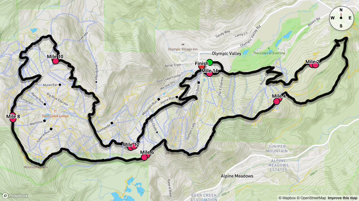
The Broken Arrow Skyrace 46k unfolds in Olympic Valley, California, beginning beneath the European arch in the Village at Palisades Tahoe and ending at the KT Sun Deck.
This high-alpine looped trail race sends runners on two laps of roughly ~14 miles each, weaving together smooth ski-area access roads, technical single-track, exposed ridge lines and alpine scrambling.
Key highlights include the sustained climb up Snow King, the technical traverse of Red Dog Ridge (featuring the iconic "Stairway to Heaven" ladder) and the fast, rocky descent through Shirley Basin back toward High Camp and the Village.
Runners start at 7:00 a.m., well after sunrise (5:33 a.m.), ensuring full daylight as temperatures typically climb from the mid-40s °F at the gun to highs near 70 °F by midday. June's 30-year climate normals show a 93 percent chance of some precipitation, with anything significant being very uncommon, but be ready for variable conditions; from clear skies to possible afternoon showers.
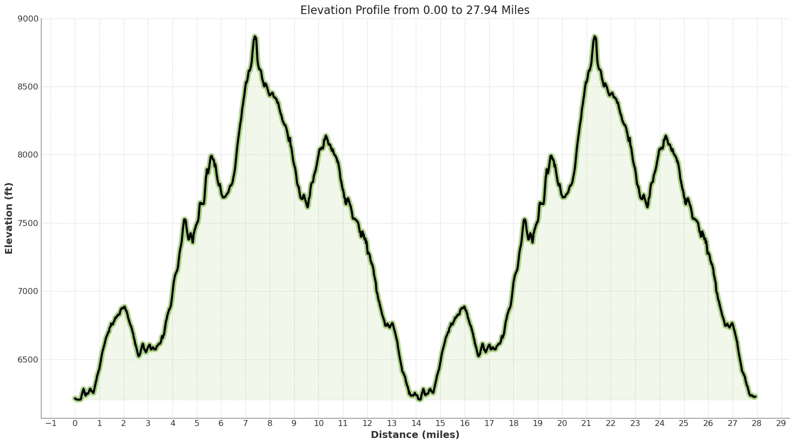
Over ~28 miles, the course accumulates nearly 8,800 ft of ascent and an almost equal descent. Early runnable miles give way to sustained climbs (most notably the scramble up to the 9,000-ft Headwall saddle) and technical, sometimes snowy descents, especially through Shirley Basin's Old Tram Road.
Learning each loop's rhythm of smooth approaches, steep pitches and rapid drops will be key for pacing and mental composure.
More than a test of physical endurance, this race is an immersive journey through Sierra Nevada history and geology. You'll follow sections of the historic Western States Trail, skirt alpine tarns, and pass landmarks like the Olympic Museum and the High Camp Pool & Hot Tub before each lap's finish at the KT Sun Deck.
Key Stats
Event Date: Saturday, June 21,2025
Event Type: Trail Race
Course Length: 28.15 miles
Course Type: Loop (2)
TrailScore: 64.08
Trail Race Difficulty Rating: Hard
Total Ascent: 8,772ft
Total Descent: 8,767ft
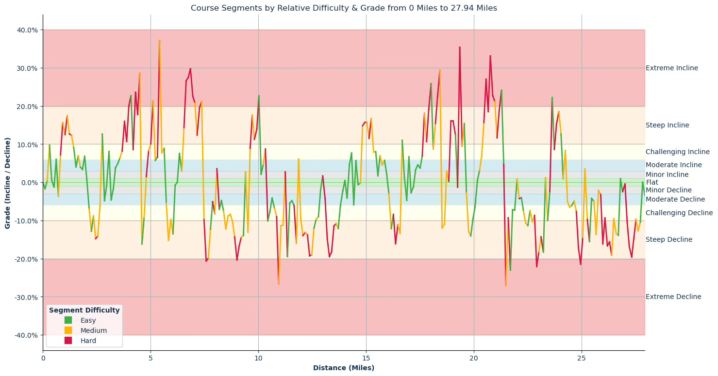
Longest Uphill:
Mile 0.82–2.15 (1.33mi at an avg 8.68% grade)
Longest Downhill:
Mile 25.27–26.82 (1.55mi at an avg –11.15% grade)
Steepest Uphill:
Mile 19.35–19.66 (0.31mi at an avg 20.12% grade)
Steepest Downhill:
Mile 21.49–22.00 (0.51mi at an avg –14.67% grade)
Significant Climbs (≥3% grade & ≥0.1mi):
There are a total of 26 significant climbs on the course.
Significant Descents (≤–3% grade & ≥0.1mi):
There are a total of 27 significant descents on the course.
Grade Distribution:
Steep Decline: 23.1%
Steep Incline: 13.6%
Challenging Decline: 12.8%
Challenging Incline: 10.6%
Extreme Incline: 8.4%
Moderate Decline: 8.1%
Moderate Incline: 6.6%
Flat: 5.9%
Minor Decline: 4.4%
Minor Incline: 4.0%
Extreme Decline: 2.6%
Course Briefing
Miles 0–5 (Village Start to Snow King Climb)
Overview
You'll depart the Village under the European arch, flowing east through the Coffeebar plaza and onto Far East parking lot access roads. The first 3.25 miles along the Western States Trail and ski-area roads are smooth and runnable, ideal for settling into your rhythm.
Beyond Mile 3, expect a steady transition onto single-track as you climb toward Snow King. Over the next two miles you'll gain roughly 950 ft, beginning on moderate pitches before the gradient ramps up near the summit. Terrain shifts from packed dirt to loose stones and narrow tread, with a handful of switchbacks to manage your effort.


Key Challenges
Pace control into the climb: The runnable approach tempts strong early effort—save energy for the sustained uphill.
Continuous ascent: Nearly 1,200 ft of gain in a short span demands disciplined effort and efficient power-to-weight pacing.
Variable footing: Loose rock and narrow trail require focused foot placement as grades increase.
Significant Climbs (≥3% grade & ≥0.1 mi)
Climb #1: Mile 0.20–0.31, 0.10 mi, avg 9.72 % (gain 53.6 ft)
Climb #2: Mile 0.52–0.62, 0.10 mi, avg 6.01 % (gain 33.1 ft)
Climb #3: Mile 0.72–1.94, 1.23 mi, avg 9.32 % (gain 603.1 ft)
Climb #4: Mile 2.65–2.76, 0.10 mi, avg 12.67 % (gain 68.7 ft)
Climb #5: Mile 2.96–3.07, 0.10 mi, avg 8.10 % (gain 43.5 ft)
Climb #6: Mile 3.27–4.50, 1.23 mi, avg 14.26 % (gain 925.1 ft)
Climb #7: Mile 4.80–5.63, 0.82 mi, avg 13.23 % (gain 575.0 ft)
Significant Descents (≤–3% grade & ≥0.1 mi)
Descent #1: Mile 0.62–0.72, 0.10 mi, avg –3.70 % (drop 19.6 ft)
Descent #2: Mile 2.04–2.65, 0.61 mi, avg –10.60 % (drop 341.1 ft)
Descent #3: Mile 2.76–2.86, 0.10 mi, avg –4.81 % (drop 26.1 ft)
Descent #4: Mile 3.07–3.17, 0.10 mi, avg –4.64 % (drop 25.3 ft)
Descent #5: Mile 4.50–4.70, 0.20 mi, avg –12.71 % (drop 136.1 ft)
Aid Stations
Snow King (Mile 5.00): Regular & gluten‑free bread, “regular” food & snacks, Tailwind drink mix, Neversecond 100‑cal gels (three flavors) and fun surprises.
Miles 5–11.75 (Snow King Descent & High Camp Approach)
Overview
From Snow King's summit, a technical 1.2-mile descent brings you back into the tree line on single-track before you begin traversing Red Dog Ridge. Expect a mix of ski-area roads and exposed ridgeline tread with sweeping views of Lake Tahoe.
Around mile 8.85, you'll hit Siberia Aid Station, then roll through a series of smaller ups and downs toward Julia Millon.
After mile 10.75, a steeper push of 550 ft in under a mile leads you to High Camp on rocky, alpine single track.


Key Challenges
Exposure on the ridge: Narrow sections on Red Dog Ridge demand sure footing and concentration.
Up‑down sequence: Successive climbs (up to 21 % grade) and steep drops test climbing power and quad strength.
High Camp ascent: The final push to 9,000 ft is short but steep, with loose rock underfoot.
Significant Climbs (≥3% grade & ≥0.1 mi)
Climb #8: Mile 6.24–6.34, 0.10 mi, avg 7.56 % (gain 40.1 ft)
Climb #9: Mile 6.45–7.37, 0.92 mi, avg 21.63 % (gain 1,055.4 ft)
Climb #10: Mile 7.98–8.08, 0.10 mi, avg 3.55 % (gain 19.1 ft)
Climb #11: Mile 9.52–10.03, 0.51 mi, avg 14.89 % (gain 403.9 ft)
Climb #12: Mile 10.13–10.33, 0.20 mi, avg 6.72 % (gain 71.2 ft)
Significant Descents (≤–3% grade & ≥0.1 mi)
Descent #6: Mile 5.63–6.04, 0.41 mi, avg –10.96 % (drop 238.4 ft)
Descent #7: Mile 7.37–7.98, 0.61 mi, avg –12.62 % (drop 407.5 ft)
Descent #8: Mile 8.08–9.31, 1.23 mi, avg –11.55 % (drop 748.8 ft)
Descent #9: Mile 9.41–9.52, 0.10 mi, avg –13.06 % (drop 70.7 ft)
Descent #10: Mile 10.33–11.15, 0.82 mi, avg –10.85 % (drop 468.6 ft)
Descent #11: Mile 11.25–11.77, 0.51 mi, avg –10.34 % (drop 280.6 ft)
Aid Stations
Siberia (Mile 8.00): Regular & gluten‑free bread, “regular” food & snacks, Tailwind drink mix, Neversecond 100‑cal gels (three flavors) and fun surprises.
Julia Millon (Mile 10.75): Regular & gluten‑free bread, “regular” food & snacks, Tailwind drink mix, Neversecond 100‑cal gels (three flavors) and fun surprises.
Points of Interest
High Camp Pool & Hot Tub (~Mile 10.4)
Olympic Museum (~Mile 10.5)
Miles 11.75–14.10 (High Camp Descent to Village)
Overview
At High Camp (11.75 mi), you'll begin a sustained 1.8-mile descent through Shirley Basin, dropping over 900 ft via Old Tram Road and flowing single track.
After a brief flat, a final moderate climb out of the basin leads you back to the Village.


Key Challenges
Early quad fatigue: The steep drop demands controlled stride to protect your quads for lap two.
Loose, uneven tread: Old Tram Road’s rocky surface calls for steady focus.
Final pitch: A short uphill just before the Village can feel surprising after the descent.
Significant Climbs (≥3% grade & ≥0.1 mi)
Climb #13: Mile 11.77–11.87, 0.10 mi, avg 6.10 % (gain 33.0 ft)
Significant Descents (≤–3% grade & ≥0.1 mi)
Descent #12: Mile 11.87–12.79, 0.92 mi, avg –13.26 % (drop 644.0 ft)
Descent #13: Mile 12.99–13.81, 0.82 mi, avg –12.13 % (drop 527.4 ft)
Descent #14: Mile 14.02–14.12, 0.10 mi, avg –4.14 % (drop 22.1 ft)
Aid Stations
Village (Mile 14.10): Regular & gluten‑free bread, “regular” food & snacks, Tailwind drink mix, Neversecond 100‑cal gels (three flavors) and fun surprises; cut‑off 1:00 p.m.
Miles 14.10–19 (Second Lap Start to Snow King Climb)
Overview
The second lap repeats the opening miles: smooth runnable trail from the Village toward Far East parking shifts to sandy single track just past mile 14.1.
Under fatigue, that familiar climb to Snow King (gaining ~950 ft over two miles) will feel sharper, especially as temperatures and sun angle peak around midday.


Significant Climbs (≥3% grade & ≥0.1 mi)
Climb #14: Mile 14.12–14.33, 0.21 mi, avg 6.18 % (gain 67.5 ft)
Climb #15: Mile 14.43–14.53, 0.10 mi, avg 5.68 % (gain 30.5 ft)
Climb #16: Mile 14.74–15.45, 0.71 mi, avg 12.92 % (gain 486.2 ft)
Climb #17: Mile 15.55–15.86, 0.31 mi, avg 5.74 % (gain 92.6 ft)
Climb #18: Mile 16.58–16.68, 0.10 mi, avg 11.04 % (gain 60.7 ft)
Climb #19: Mile 16.89–16.99, 0.10 mi, avg 6.66 % (gain 36.6 ft)
Climb #20: Mile 17.20–18.43, 1.23 mi, avg 14.07 % (gain 912.5 ft)
Climb #21: Mile 18.84–19.15, 0.31 mi, avg 14.86 % (gain 242.1 ft)
Significant Descents (≤–3% grade & ≥0.1 mi)
Descent #15: Mile 14.33–14.43, 0.10 mi, avg –5.90 % (drop 31.3 ft)
Descent #16: Mile 15.96–16.58, 0.61 mi, avg –10.69 % (drop 346.2 ft)
Descent #17: Mile 16.78–16.89, 0.10 mi, avg –4.73 % (drop 25.5 ft)
Descent #18: Mile 18.43–18.64, 0.21 mi, avg –11.49 % (drop 126.3 ft)
Aid Stations
Snow King (Mile 19.00): Village (Mile 14.10): Regular & gluten‑free bread, “regular” food & snacks, Tailwind drink mix, Neversecond 100‑cal gels (three flavors) and fun surprises; cut‑off 3:00 p.m.
Miles 19–24.70 (Snow King Descent, Shirley Basin & High Camp Approach)
Overview
Descending Snow King again, you'll navigate potentially snowy single track into Shirley Basin.
After Siberia (Mile 22), the course climbs approximately 550 feet over 0.9 miles back toward Julia Millon, with granite-strewn tread that feels considerably more challenging on your second lap.


Key Challenges
Potential Snow and ice: Depending on the year, patches in Shirley Basin could require extra agility and careful footing.
Steep canyon terrain: Rapid transition from exposed ridge to forested descent tests handling.
Final High Camp push: That short climb into Julia Millon can sting after the earlier cumulative gain.
Significant Climbs (≥3% grade & ≥0.1 mi)
Climb #22: Mile 19.25–19.56, 0.31 mi, avg 20.12 % (gain 327.2 ft)
Climb #23: Mile 20.17–21.39, 1.22 mi, avg 17.33 % (gain 1,119.6 ft)
Climb #24: Mile 23.53–24.05, 0.51 mi, avg 15.47 % (gain 420.0 ft)
Climb #25: Mile 24.15–24.25, 0.10 mi, avg 8.35 % (gain 45.6 ft)
Significant Descents (≤–3% grade & ≥0.1 mi)
Descent #19: Mile 19.66–20.06, 0.41 mi, avg –10.78 % (drop 232.3 ft)
Descent #20: Mile 21.39–21.90, 0.51 mi, avg –14.67 % (drop 398.3 ft)
Descent #21: Mile 22.01–23.23, 1.22 mi, avg –11.46 % (drop 738.4 ft)
Descent #22: Mile 23.33–23.43, 0.10 mi, avg –10.02 % (drop 54.2 ft)
Descent #23: Mile 24.25–25.06, 0.81 mi, avg –10.42 % (drop 446.9 ft)
Aid Stations
Siberia (Mile 22.00): Regular & gluten‑free bread, “regular” food & snacks, Tailwind drink mix, Neversecond 100‑cal gels (three flavors) and fun surprises; cut‑off 5:15 p.m.
Julia Millon (Mile 24.70): Regular & gluten‑free bread, “regular” food & snacks, Tailwind drink mix, Neversecond 100‑cal gels (three flavors) and fun surprises; cut‑off 6:15 p.m.
Points of Interest
High Camp Pool & Hot Tub (~Mile 24.25)
Olympic Museum (~Mile 24.35)
Miles 24.70–Finish (Final Descent & Finish)
Overview
Leaving Julia Millon, a brief climb precedes an extended technical descent down Old Tram Road and Granite Chief Road.
The final mile along Village East Road offers a gentle approach to the KT Sun Deck finish arch, where a final sustainable kick can seal your race.


Key Challenges
Descending under fatigue: Tired quads need managed stride to avoid strain.
Loose, rocky tread: Watch your footing on Old Tram Road’s uneven surface.
Finishing rhythm: The final flat demands balanced effort for a strong finish.
Significant Climbs (≥3% grade & ≥0.1 mi)
Climb #26: Mile 25.06–25.16, 0.10 mi, avg 3.48 % (gain 18.6 ft)
Significant Descents (≤–3% grade & ≥0.1 mi)
Descent #24: Mile 25.16–25.68, 0.52 mi, avg –9.61 % (drop 262.9 ft)
Descent #25: Mile 25.79–26.71, 0.92 mi, avg –13.03 % (drop 635.2 ft)
Descent #26: Mile 27.02–27.73, 0.72 mi, avg –13.54 % (drop 514.2 ft)
Descent #27: Mile 27.84–27.94, 0.10 mi, avg –3.45 % (drop 18.9 ft)
Aid Stations
None—plan to carry any final nutrition.
Points of Interest
Palisade / Olympic Valley (~Mile 27.9)