[Preview] Personalized Course Guides
A look at the worst our personalized guides will ever be...
Hey Friends!
Below is a preview of the personalized course guides I’ve been working on (specifically - this is my course guide for the Superior Fall 50), and the best thing I can say is that this is the worst they will ever be.
The basic idea here is that paid subscribers will be given access to a system where they:
Select one of our existing course guides.
Specify A, B, & C goals for the race in terms of finishing times.
e.g. 11 hours, 30 minutes
Specify a pacing strategy for each goal.
I’m currently working on support for Even Pace, Even Effort, Negative Split, Aggressive Negative Split, Positive Split, Aggressive Positive Split.
Specify the average time they plan to spend at each aid station.
Then press submit, and boom! The personalized guide shows up in your inbox a few minutes later.
If I were to detail everything I want to do with personalized guides, this update would easily be twice as long. What I want to do isn’t as important as what everyone else would want from these guides.
So please, leave feedback! Tell me what’s missing and what I’ve totally screwed up.
Thank you all,
-Dakota
Course Overview
The Superior Fall Trail Race 50MI is a formidable point-to-point ultramarathon that charts a demanding course through the Sawtooth Mountain Range in Northern Minnesota. Covering 51.55 miles almost entirely on the rugged and technical single-track of the Superior Hiking Trail, the race begins at the Finland Community Center and concludes at Caribou Highlands Lodge on Lutsen Mountain. The route is a showcase of the region's raw beauty, paralleling the vast expanse of Lake Superior, ascending to peaks with expansive views, and crossing numerous rivers and streams within a classic boreal forest ecosystem.
Weather in early September along the North Shore is typically cool and unpredictable. The 5:15 AM start ensures you will begin in darkness, with historical temperatures near 51°F. While daytime highs average in the mid-60s, conditions can change rapidly. The five-year average includes nearly four hours of precipitation on race day; plan for wet and muddy trails, which will add to the technical challenge of the terrain.
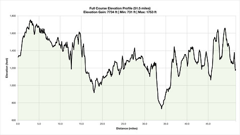
The course profile is defined by its relentless, undulating nature. With approximately 7,150 feet of elevation gain and 7,250 feet of descent, the challenge comes not from long, singular mountain ascents, but from a continuous series of dozens of steep, punchy climbs and equally abrupt downhills. There are very few flat sections, demanding constant mental focus and physical adaptation. Successfully navigating this course requires a strategy centered on conservative pacing, efficient power-hiking on the inclines, and careful, controlled running on the descents to preserve your legs for the entire 51.55-mile journey.
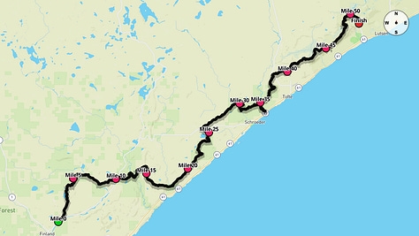
Course Stats
Event Date: September 6, 2025
Event Type: Trail Ultramarathon
Course Length: 51.55 mi
Course Type: Point to Point
TrailScore: 107.39
TrailScore Difficulty Rating for Trail Ultramarathons: Hard
Total Ascent: 7149.51 ft
Total Descent: 7256.1 ft
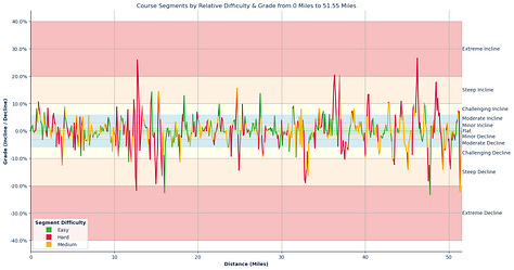
Longest Uphill: Starting at Mile 38.16, 1.02 mi at an average grade of 3.41%
Longest Downhill: Starting at Mile 32.64, 1.43 mi at an average grade of -6.71%
Steepest Uphill: Starting at Mile 12.74, 0.31 mi at an average grade of 18.33%
Steepest Downhill: Starting at Mile 12.54, 0.20 mi at an average grade of -19.27%
Significant Climbs (≥3% grade & ≥0.1 mi):
There are a total of 63 significant climbs on the course.
Significant Descents (≤-3% grade & ≥0.1 mi):
There are a total of 60 significant descents on the course.
Grade Distribution:
Flat: 22.7%
Minor Decline: 15.6%
Minor Incline: 13.6%
Moderate Incline: 12.5%
Moderate Decline: 9.3%
Challenging Decline: 7.9%
Challenging Incline: 7.3%
Steep Decline: 5.1%
Steep Incline: 4.3%
Extreme Decline: 0.8%
Extreme Incline: 0.8%
Athlete Goals
Course Briefing
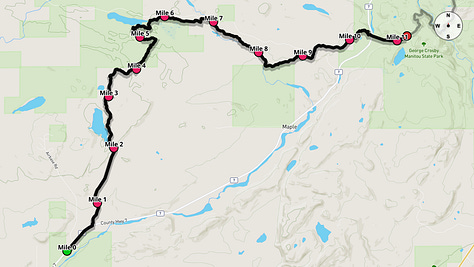
Miles 0-11.2 - From Finland to Crosby-Manitou
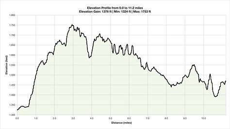
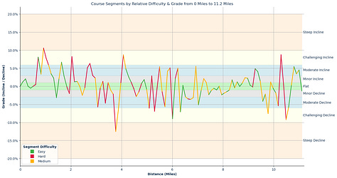
Your race begins well before sunrise at the Finland Community Center. After a brief stretch on paved roads, you'll enter the Superior Hiking Trail and be immediately immersed in the rugged single-track that defines this event. The darkness will amplify the trail's technicality, requiring sharp focus on the path illuminated by your headlamp. The terrain is a constant rollercoaster of short, sharp climbs followed by quick descents through dense forest.
This initial segment is about managing your effort and expectations. The excitement of the start can tempt you to push too hard, but the cumulative effect of these early hills will be felt later in the race. Settle into a conservative pace, power-hike the steeper inclines with purpose, and navigate the downhills with care. Your primary goals are to stay upright, conserve energy, and reach the first major aid station at Crosby-Manitou feeling controlled and ready for what's next.
Section Splits
Key Challenges
Pre-Dawn Navigation: With a 5:15 AM start, you'll run on technical single-track in darkness for at least the first hour. A reliable, powerful headlamp is essential for safely navigating the roots and rocks.
Relentless Early Undulations: The course immediately introduces its signature challenge. This opening section contains 12 significant climbs and 16 descents, forcing you to establish a sustainable rhythm early to conserve energy.
Significant Climbs (≥3% grade & ≥0.1 mi)
Climb #1: Mile 0.61 to 1.22, 0.61 mi, avg grade 6.55%, total gain 209.6 ft
Climb #2: Mile 1.53 to 1.63, 0.10 mi, avg grade 6.66%, total gain 36.1 ft
Climb #3: Mile 1.94 to 2.04, 0.10 mi, avg grade 8.20%, total gain 44.0 ft
Climb #4: Mile 2.55 to 2.75, 0.20 mi, avg grade 5.73%, total gain 61.8 ft
Climb #5: Mile 3.97 to 4.17, 0.20 mi, avg grade 6.75%, total gain 71.8 ft
Climb #6: Mile 5.40 to 5.50, 0.10 mi, avg grade 5.40%, total gain 29.4 ft
Climb #7: Mile 5.71 to 5.91, 0.21 mi, avg grade 4.61%, total gain 50.3 ft
Climb #8: Mile 6.12 to 6.22, 0.10 mi, avg grade 4.99%, total gain 26.6 ft
Climb #9: Mile 6.83 to 6.93, 0.10 mi, avg grade 5.53%, total gain 29.8 ft
Climb #10: Mile 9.17 to 9.37, 0.20 mi, avg grade 4.47%, total gain 47.5 ft
Climb #11: Mile 10.18 to 10.29, 0.10 mi, avg grade 8.72%, total gain 47.8 ft
Climb #12: Mile 10.70 to 11.00, 0.31 mi, avg grade 4.47%, total gain 72.6 ft
Significant Descents (≤-3% grade & ≥0.1 mi)
Descent #1: Mile 1.32 to 1.43, 0.10 mi, avg grade -3.13%, total drop 17.0 ft
Descent #2: Mile 2.96 to 3.06, 0.10 mi, avg grade -5.70%, total drop 30.6 ft
Descent #3: Mile 3.26 to 3.36, 0.10 mi, avg grade -4.66%, total drop 24.9 ft
Descent #4: Mile 3.67 to 3.87, 0.20 mi, avg grade -9.58%, total drop 101.8 ft
Descent #5: Mile 4.99 to 5.09, 0.10 mi, avg grade -6.03%, total drop 32.0 ft
Descent #6: Mile 5.19 to 5.30, 0.10 mi, avg grade -6.90%, total drop 37.7 ft
Descent #7: Mile 5.60 to 5.71, 0.10 mi, avg grade -5.64%, total drop 30.8 ft
Descent #8: Mile 5.91 to 6.01, 0.10 mi, avg grade -8.96%, total drop 47.4 ft
Descent #9: Mile 6.22 to 6.32, 0.10 mi, avg grade -7.05%, total drop 38.8 ft
Descent #10: Mile 6.52 to 6.83, 0.30 mi, avg grade -3.41%, total drop 54.5 ft
Descent #11: Mile 6.93 to 7.03, 0.10 mi, avg grade -5.11%, total drop 28.3 ft
Descent #12: Mile 9.47 to 9.57, 0.10 mi, avg grade -4.14%, total drop 22.2 ft
Descent #13: Mile 9.67 to 9.78, 0.10 mi, avg grade -7.54%, total drop 41.0 ft
Descent #14: Mile 10.08 to 10.18, 0.10 mi, avg grade -5.38%, total drop 28.5 ft
Descent #15: Mile 10.39 to 10.59, 0.20 mi, avg grade -7.52%, total drop 80.7 ft
Descent #16: Mile 11.31 to 11.41, 0.10 mi, avg grade -5.58%, total drop 30.5 ft
Aid Stations
Sonju Lake Road (Mile 7)
Offerings: A variety of sweet and salty snacks, Coke, Ginger Ale, and hot food options like soup and grilled cheese.
Drop Bags: Yes
Crew Access: No
Cutoff: N/A
Toilet: Yes
Crosby-Manitou (Mile 11.2)
Offerings: A variety of sweet and salty snacks, Coke, Ginger Ale, and hot food options like soup and grilled cheese.
Drop Bags: Yes
Crew Access: Yes
Cutoff: Sat. 9:10 AM
Toilet: Yes
Points of Interest
SHT Trail Head - Finland (~Mile 0.0): The official start of the race.
George H. Crosby Manitou State Park (~Mile 10.5): You'll be running through the rugged terrain of this state park, known for its dramatic river gorge.
Benson Lake Loop Trailhead (~Mile 11.1): Trailhead near the Crosby-Manitou aid station.
Miles 11.2-26.4 - The Rugged Heart
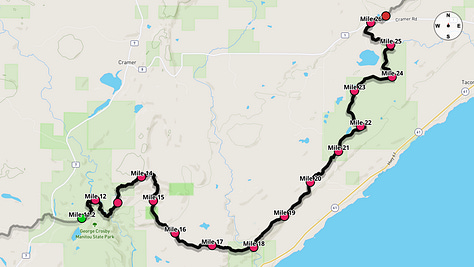
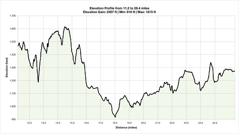
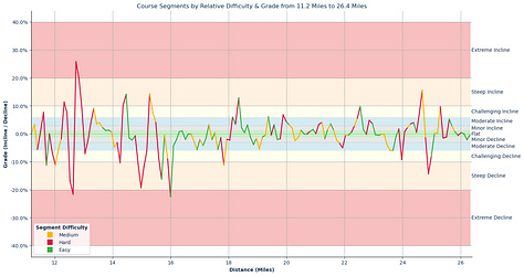
Leaving the Crosby-Manitou aid station, you enter what is arguably the most demanding section of the course. The terrain intensifies, presenting you with the steepest climb and descent of the entire race. This gauntlet around mile 12.5 is a true test of your technical skill and leg strength, both on the way down and the way up. The sharp, aggressive nature of the Sawtooth Mountains is on full display here.
The challenge doesn't relent after this key feature. For the next 15 miles, the course continues its chaotic rhythm of abrupt ups and downs. You will traverse ridges and dive into hollows, with the trail surface remaining consistently rugged. The marathon mark is crossed within this segment, but the feel is far from a road marathon. Focus on efficient movement, use your poles effectively if you have them, and stay on top of your nutrition as you work your way toward the Cramer Road aid station.
Section Splits
Key Challenges
The Steepest Gauntlet: Immediately after Crosby-Manitou, prepare for the race's steepest pitches. Between miles 12.4 and 12.9, you face a sharp descent averaging over a -19% grade followed instantly by a climb averaging over 18%. This is a critical point requiring careful navigation and controlled power.
Sustained Technicality: This entire section is a masterclass in technical trail running. The Superior Hiking Trail serves up a relentless combination of rocks, roots, and tight switchbacks that demand constant vigilance. Foot placement is key to conserving energy and avoiding falls.
Significant Climbs (≥3% grade & ≥0.1 mi)
Climb #13: Mile 11.21 to 11.31, 0.10 mi, avg grade 3.37%, total gain 17.9 ft
Climb #14: Mile 11.51 to 11.62, 0.10 mi, avg grade 7.68%, total gain 41.1 ft
Climb #15: Mile 12.23 to 12.43, 0.20 mi, avg grade 9.40%, total gain 100.7 ft
Climb #16: Mile 12.64 to 12.94, 0.31 mi, avg grade 18.33%, total gain 297.2 ft
Climb #17: Mile 13.15 to 13.55, 0.41 mi, avg grade 5.13%, total gain 110.0 ft
Climb #18: Mile 14.26 to 14.47, 0.21 mi, avg grade 12.17%, total gain 131.8 ft
Climb #19: Mile 15.18 to 15.49, 0.31 mi, avg grade 8.58%, total gain 138.4 ft
Climb #20: Mile 17.22 to 17.32, 0.10 mi, avg grade 3.23%, total gain 17.4 ft
Climb #21: Mile 18.04 to 18.35, 0.31 mi, avg grade 7.43%, total gain 121.0 ft
Climb #22: Mile 18.55 to 18.65, 0.10 mi, avg grade 3.17%, total gain 17.2 ft
Climb #23: Mile 19.27 to 19.37, 0.10 mi, avg grade 6.06%, total gain 33.1 ft
Climb #24: Mile 19.47 to 19.57, 0.10 mi, avg grade 3.23%, total gain 17.2 ft
Climb #25: Mile 19.78 to 20.09, 0.31 mi, avg grade 4.78%, total gain 78.7 ft
Climb #26: Mile 21.01 to 21.22, 0.20 mi, avg grade 3.73%, total gain 40.4 ft
Climb #27: Mile 21.42 to 21.52, 0.10 mi, avg grade 3.57%, total gain 19.1 ft
Climb #28: Mile 22.34 to 22.54, 0.20 mi, avg grade 7.62%, total gain 81.4 ft
Climb #29: Mile 22.75 to 22.96, 0.21 mi, avg grade 4.25%, total gain 46.3 ft
Climb #30: Mile 24.17 to 24.38, 0.20 mi, avg grade 3.79%, total gain 40.7 ft
Climb #31: Mile 24.48 to 24.68, 0.21 mi, avg grade 11.51%, total gain 124.7 ft
Climb #32: Mile 25.20 to 25.30, 0.10 mi, avg grade 9.68%, total gain 51.9 ft
Climb #33: Mile 25.51 to 25.61, 0.10 mi, avg grade 5.23%, total gain 28.5 ft
Climb #34: Mile 26.83 to 26.94, 0.10 mi, avg grade 4.20%, total gain 22.8 ft
Significant Descents (≤-3% grade & ≥0.1 mi)
Descent #17: Mile 11.62 to 11.72, 0.10 mi, avg grade -11.16%, total drop 61.5 ft
Descent #18: Mile 11.82 to 12.13, 0.31 mi, avg grade -7.80%, total drop 126.5 ft
Descent #19: Mile 12.43 to 12.64, 0.20 mi, avg grade -19.27%, total drop 205.7 ft
Descent #20: Mile 12.94 to 13.05, 0.10 mi, avg grade -7.03%, total drop 38.1 ft
Descent #21: Mile 13.96 to 14.26, 0.30 mi, avg grade -6.05%, total drop 97.3 ft
Descent #22: Mile 14.78 to 15.18, 0.41 mi, avg grade -11.95%, total drop 257.1 ft
Descent #23: Mile 15.49 to 15.69, 0.20 mi, avg grade -12.34%, total drop 132.5 ft
Descent #24: Mile 15.79 to 16.10, 0.30 mi, avg grade -11.92%, total drop 191.1 ft
Descent #25: Mile 16.81 to 16.91, 0.10 mi, avg grade -5.69%, total drop 30.3 ft
Descent #26: Mile 17.01 to 17.12, 0.10 mi, avg grade -4.16%, total drop 22.5 ft
Descent #27: Mile 17.53 to 17.63, 0.10 mi, avg grade -5.59%, total drop 30.7 ft
Descent #28: Mile 17.73 to 17.84, 0.10 mi, avg grade -11.16%, total drop 59.3 ft
Descent #29: Mile 18.75 to 18.86, 0.10 mi, avg grade -3.84%, total drop 20.9 ft
Descent #30: Mile 18.96 to 19.06, 0.10 mi, avg grade -5.47%, total drop 29.5 ft
Descent #31: Mile 21.73 to 21.93, 0.21 mi, avg grade -4.23%, total drop 46.5 ft
Aid Stations
Sugarloaf (Mile 20.8)
Offerings: A variety of sweet and salty snacks, Coke, Ginger Ale, and hot food options like soup and grilled cheese.
Drop Bags: Yes
Crew Access: Yes
Cutoff: Sat. 12:10 PM
Toilet: Yes
Cramer RD (Mile 26.4)
Offerings: A variety of sweet and salty snacks, Coke, Ginger Ale, and hot food options like soup and grilled cheese.
Drop Bags: Yes
Crew Access: Yes
Cutoff: Sat. 1:45 PM
Toilet: Yes
Points of Interest
Superior Hiking Trail Sugarloaf Trail Head (~Mile 20.7): Trailhead providing access to the Sugarloaf aid station.
Cramer Road Superior Hiking Trail Trailhead (~Mile 26.0): Marks the end of the section and the location of the Cramer Road aid station.
Miles 26.4-38.7 - The Temperance River & Carlton Peak
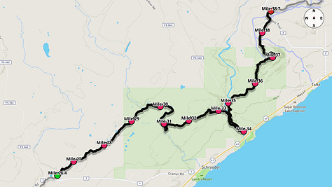
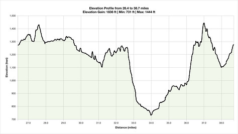
As you pass the halfway point, the course offers a slight change in character, though no decrease in difficulty. This segment features the longest period of sustained downhill on the course, providing a rare opportunity to open your stride. However, this is a deceptive gift that can punish overeager legs. This descent leads you towards the Temperance River, where you'll navigate another sharp drop and climb out of the gorge before arriving at the Temperance aid station.
The centerpiece of this section is the formidable climb to Carlton Peak. This is one of the most significant and sustained ascents of the day, coming at a point when fatigue is setting in. Reaching the summit offers spectacular panoramic views, a mental boost for the miles ahead. The long, winding descent from the peak brings you down towards the Sawbill aid station, setting you up for the final push to the finish.
Section Splits
Key Challenges
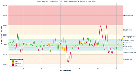
Longest Sustained Downhill: Beginning around mile 32.6, the course offers its longest period of sustained downhill running. While the data breaks this into individual pitches, like the steep -13% grade section dropping into the Temperance River gorge, you should mentally prepare for a prolonged and taxing descent that demands control to save your quads.
Carlton Peak Climb & Descent: The major geographical feature of this section is the climb to Carlton Peak around mile 36. This includes a very steep half-mile section averaging over 12%. The rewarding views are earned; the subsequent technical descent requires focus on tired legs.
Significant Climbs (≥3% grade & ≥0.1 mi)
Climb #35: Mile 27.34 to 27.54, 0.20 mi, avg grade 9.06%, total gain 97.0 ft
Climb #36: Mile 29.07 to 29.17, 0.10 mi, avg grade 5.41%, total gain 28.7 ft
Climb #37: Mile 29.89 to 29.99, 0.10 mi, avg grade 3.78%, total gain 20.2 ft
Climb #38: Mile 31.21 to 31.42, 0.21 mi, avg grade 8.70%, total gain 95.0 ft
Climb #39: Mile 31.83 to 31.93, 0.10 mi, avg grade 3.52%, total gain 18.9 ft
Climb #40: Mile 32.03 to 32.13, 0.10 mi, avg grade 5.03%, total gain 26.8 ft
Climb #41: Mile 32.24 to 32.34, 0.10 mi, avg grade 7.85%, total gain 41.5 ft
Climb #42: Mile 32.44 to 32.54, 0.10 mi, avg grade 3.93%, total gain 20.8 ft
Climb #43: Mile 33.97 to 34.07, 0.10 mi, avg grade 4.40%, total gain 23.4 ft
Climb #44: Mile 34.38 to 34.48, 0.10 mi, avg grade 8.05%, total gain 43.0 ft
Climb #45: Mile 34.78 to 34.99, 0.21 mi, avg grade 6.75%, total gain 73.8 ft
Climb #46: Mile 35.09 to 35.19, 0.10 mi, avg grade 6.04%, total gain 32.4 ft
Climb #47: Mile 35.61 to 35.71, 0.10 mi, avg grade 5.97%, total gain 32.6 ft
Climb #48: Mile 35.81 to 35.91, 0.10 mi, avg grade 4.17%, total gain 22.3 ft
Climb #49: Mile 36.01 to 36.53, 0.51 mi, avg grade 12.12%, total gain 328.6 ft
Climb #50: Mile 36.73 to 37.04, 0.31 mi, avg grade 10.17%, total gain 164.5 ft
Significant Descents (≤-3% grade & ≥0.1 mi)
Descent #32: Mile 24.79 to 24.99, 0.21 mi, avg grade -11.21%, total drop 122.0 ft
Descent #33: Mile 27.14 to 27.24, 0.10 mi, avg grade -6.59%, total drop 35.7 ft
Descent #34: Mile 27.64 to 27.95, 0.31 mi, avg grade -7.16%, total drop 116.4 ft
Descent #35: Mile 29.58 to 29.78, 0.20 mi, avg grade -6.32%, total drop 67.3 ft
Descent #36: Mile 29.99 to 30.09, 0.10 mi, avg grade -5.21%, total drop 28.1 ft
Descent #37: Mile 30.80 to 30.91, 0.10 mi, avg grade -7.44%, total drop 40.6 ft
Descent #38: Mile 31.62 to 31.73, 0.10 mi, avg grade -9.53%, total drop 51.8 ft
Descent #39: Mile 32.13 to 32.24, 0.10 mi, avg grade -4.86%, total drop 26.4 ft
Descent #40: Mile 32.34 to 32.44, 0.10 mi, avg grade -6.02%, total drop 32.8 ft
Descent #41: Mile 32.64 to 33.25, 0.61 mi, avg grade -13.16%, total drop 423.9 ft
Descent #42: Mile 33.35 to 33.46, 0.10 mi, avg grade -3.12%, total drop 16.7 ft
Descent #43: Mile 33.87 to 33.97, 0.10 mi, avg grade -6.19%, total drop 33.9 ft
Descent #44: Mile 36.63 to 36.73, 0.10 mi, avg grade -5.55%, total drop 30.2 ft
Descent #45: Mile 37.04 to 37.95, 0.92 mi, avg grade -6.45%, total drop 312.8 ft
Descent #46: Mile 39.69 to 39.80, 0.10 mi, avg grade -3.52%, total drop 19.2 ft
Aid Stations
Temperance (Mile 33.3)
Offerings: A variety of sweet and salty snacks, Coke, Ginger Ale, and hot food options like soup and grilled cheese.
Drop Bags: Yes
Crew Access: No
Cutoff: Sat. 4:00 PM
Toilet: Yes
Sawbill (Mile 38.7)
Offerings: A variety of sweet and salty snacks, Coke, Ginger Ale, and hot food options like soup and grilled cheese.
Drop Bags: Yes
Crew Access: Yes
Cutoff: Sat. 5:40 PM
Toilet: Yes
Points of Interest
Boney's Meadow (~Mile 28.7): A scenic meadow area along the trail.
Carlton Peak (~Mile 36.8): A major climb on the course with rewarding views of Lake Superior and the surrounding forest.
Britton Peak Trailhead (~Mile 38.5): Trailhead near the Sawbill aid station.
Miles 38.7-51.55 - The Final Push to Lutsen
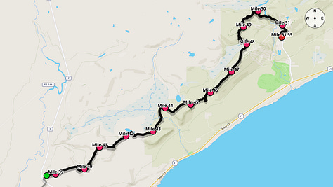
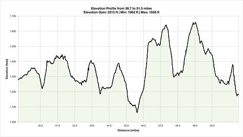
The final 13 miles from the Sawbill aid station to the finish at Lutsen are a true test of an ultramarathoner's spirit. There is no easy cruise to the finish. The course continues its relentless pattern of steep climbs and technical descents. After a brief respite, you will tackle the significant climb up Oberg Mountain, a popular local hike known for its vistas, which you will earn with a tough ascent. This is followed by another punishing climb up Mystery Mountain.
After cresting the final major peak, the course transitions to the ski slopes of Lutsen. You'll navigate a series of service roads and trails, making one final small climb before the exhilarating but treacherous final descent. The finish line at Caribou Highlands Lodge is a welcome sight, but it only comes after you've conquered this last, steep pitch. Crossing that line is a testament to your endurance and skill in handling one of the most rugged 50-milers in the country.
Section Splits
Key Challenges
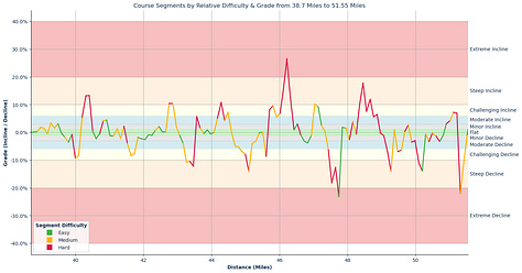
The Oberg Mountain Climb: Don't be fooled by the late mileage; this section has teeth. The climb up and around Oberg Mountain starting at mile 45.6 is a significant hurdle, gaining over 450 feet in just 0.7 miles with an average grade over 12%.
Mystery Mountain Ascent: After Oberg, another demanding climb awaits up Mystery Mountain. This 0.6-mile grind starting at mile 48.26 averages nearly 10% and will test your resolve.
Final Plunge to the Finish: The race concludes with a steep, 0.2-mile ski hill descent averaging a -16.6% grade. Navigating this on exhausted legs requires supreme concentration to avoid a fall just before the finish line.
Significant Climbs (≥3% grade & ≥0.1 mi)
Climb #51: Mile 38.26 to 38.67, 0.41 mi, avg grade 6.31%, total gain 136.7 ft
Climb #52: Mile 39.18 to 39.28, 0.10 mi, avg grade 3.40%, total gain 18.4 ft
Climb #53: Mile 39.39 to 39.49, 0.10 mi, avg grade 3.13%, total gain 16.8 ft
Climb #54: Mile 40.10 to 40.41, 0.31 mi, avg grade 10.61%, total gain 172.1 ft
Climb #55: Mile 40.72 to 40.92, 0.20 mi, avg grade 4.29%, total gain 45.8 ft
Climb #56: Mile 42.66 to 42.87, 0.20 mi, avg grade 10.40%, total gain 112.1 ft
Climb #57: Mile 43.47 to 43.57, 0.10 mi, avg grade 5.70%, total gain 30.2 ft
Climb #58: Mile 44.08 to 44.49, 0.41 mi, avg grade 6.84%, total gain 147.6 ft
Climb #59: Mile 45.61 to 46.32, 0.71 mi, avg grade 12.16%, total gain 455.9 ft
Climb #60: Mile 46.94 to 47.14, 0.20 mi, avg grade 9.70%, total gain 102.7 ft
Climb #61: Mile 48.06 to 48.16, 0.10 mi, avg grade 3.81%, total gain 20.6 ft
Climb #62: Mile 48.26 to 48.87, 0.61 mi, avg grade 9.89%, total gain 318.5 ft
Climb #63: Mile 50.81 to 51.22, 0.41 mi, avg grade 5.35%, total gain 115.3 ft
Significant Descents (≤-3% grade & ≥0.1 mi)
Descent #47: Mile 39.90 to 40.10, 0.20 mi, avg grade -8.89%, total drop 94.5 ft
Descent #48: Mile 41.43 to 41.74, 0.31 mi, avg grade -6.69%, total drop 108.7 ft
Descent #49: Mile 43.07 to 43.47, 0.41 mi, avg grade -9.38%, total drop 200.5 ft
Descent #50: Mile 44.60 to 45.31, 0.71 mi, avg grade -6.60%, total drop 247.4 ft
Descent #51: Mile 45.51 to 45.61, 0.10 mi, avg grade -8.64%, total drop 45.9 ft
Descent #52: Mile 46.63 to 46.83, 0.20 mi, avg grade -3.49%, total drop 37.6 ft
Descent #53: Mile 47.34 to 47.75, 0.41 mi, avg grade -15.16%, total drop 327.5 ft
Descent #54: Mile 49.07 to 49.28, 0.21 mi, avg grade -10.48%, total drop 113.6 ft
Descent #55: Mile 49.38 to 49.59, 0.21 mi, avg grade -6.67%, total drop 72.3 ft
Descent #56: Mile 49.79 to 49.89, 0.10 mi, avg grade -3.52%, total drop 19.3 ft
Descent #57: Mile 49.99 to 50.20, 0.20 mi, avg grade -12.47%, total drop 134.9 ft
Descent #58: Mile 50.30 to 50.40, 0.10 mi, avg grade -3.33%, total drop 17.9 ft
Descent #59: Mile 50.61 to 50.71, 0.10 mi, avg grade -3.30%, total drop 17.7 ft
Descent #60: Mile 51.22 to 51.42, 0.20 mi, avg grade -16.63%, total drop 179.5 ft
Aid Stations
Oberg (Mile 44.2)
Offerings: A variety of sweet and salty snacks, Coke, Ginger Ale, and hot food options like soup and grilled cheese.
Drop Bags: Yes
Crew Access: Yes
Cutoff: Sat. 7:10 PM
Toilet: Yes
Points of Interest
Oberg Mountain Trail Head (~Mile 44.2) (Spectator Zone): Trailhead providing access to the final manned aid station before the finish.
Lutsen Mountains (~Mile 50.9) (Spectator Zone): The course enters the ski resort area for the final miles.
Finish Line (~Mile 51.5) (Spectator Zone): The race finish at Caribou Highlands Lodge.
Appendix
Goal Splits
Goal A
Start: 5:15:00 AM
Goal Time: 13 Hours 30 Minutes
Finish: 6:15:00 PM
Pacing Strategy: Even Effort
Goal B
Start: 05:15:00
Goal Time: 14 Hours 30 Minutes
Finish: 7:45:00
Pacing Strategy: Even Effort
Goal C
Start: 05:15:00
Goal Time: 16 Hours 00 Minutes
Finish: 9:15:00 PM
Pacing Strategy: Aggressive Positive Split


