


2025 Surf City Marathon Course Guide
A beautiful day at the beach, and a lot of running back and forth.

Note: This guide is based on a GPX file created from an interpretation of the official course map. The official course distance is 26.2 miles, which is the shortest possible route while staying within the course boundaries. The GPX file measures the course at 26.33 miles, so distances in the guide are approximate.
Course Overview
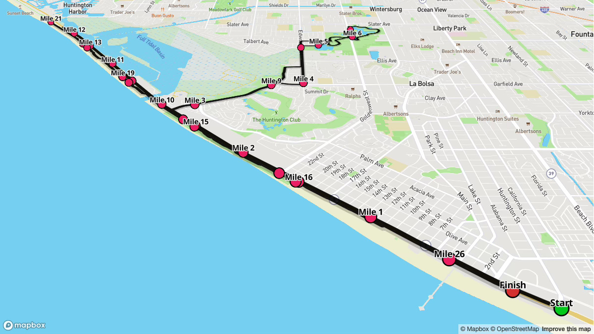
Surf City Marathon offers a quintessential Southern California experience, showcasing an extended stretch along the Pacific Coast Highway, with a brief inland loop from Miles 2.8 to 9.9. Starting at 6:30 a.m.—just before sunrise—you’ll quickly witness daylight over the Pacific. Most of the route is flat or gently rolling, except for a few notable inclines in the inland section.
Runners can expect ideal racing conditions, with starting temperatures in the low 50s°F under clear skies at the start. As the day progresses, temperatures gradually warm to the mid-to-upper 60s°F.
Overall, the course features ocean breezes, mild temperatures, and iconic beach views that define the event’s atmosphere.

Key Stats
Event Date: February 2, 2025
Event Type: Road Marathon
Course Length: 26.2 miles
Course Type: Loop
TrailScore: 38.78
Road Marathon Rating: Easy
Total Ascent: 377.07 feet
Total Descent: 363.35 feet
Longest Uphill: 1.65 miles at an average grade of 0.10%, starting at 12.08 miles
Longest Downhill: 1.08 miles at an average grade of -0.11%, starting at 15.18 miles
Steepest Uphill: 0.31 miles at an average grade of 3.11%, starting at 5.11 miles
Steepest Downhill: 0.99 miles at an average grade of -1.99%, starting at 4.11 miles
Grade Distribution:
Flat: 85.6%
Minor Incline: 5.8%
Minor Decline: 5.8%
Moderate Decline: 1.6%
Moderate Incline: 1.2%
Course Briefing
Miles 0-2.8 (Beachfront Start)
Overview
You’ll start at 6:30 a.m. on the Pacific Coast Highway in Huntington Beach, with first light on the horizon. Temperatures should be around 53°F, and conditions are generally clear. This section is predominantly flat—great for easing into your target pace. You’ll pass near the pier and amphitheater, soaking up the early coastal ambiance.


Key Challenges
Minimal elevation change here; be mindful not to get carried away and go out too fast.
Aid Stations
Mile 1.5: Gatorade, Water
Mile 2.5: Water
Points of Interest
Pier Plaza and Amphitheater (Near Start): A popular hub along the ocean, buzzing with local surf culture.
Miles 2.8-9.9 (Inland Loop)
Overview
Around Mile 2.8, the course veers inland through residential streets and local parks. Expect rolling hills here—this segment has more noticeable inclines and declines than the rest of the course. Maintain an even effort rather than aiming for exact splits; pace fluctuations are natural with the terrain shifts.


Key Challenges
Rolling Terrain: A blend of minor and moderate inclines/declines can disrupt your rhythm.
Steepest Uphill/Downhill: Look out for short but steeper sections around Miles 4–6 and again near 8–9. Conserve energy to avoid early fatigue.
Aid Stations
Mile 4.5: Gatorade, Water
Mile 6: Gatorade, Water
Mile 7: Gatorade, Water
Mile 8.5: Gatorade, Water
Mile 9.5: Water
Points of Interest
Harriett M. Wieder Regional Park (Approx. Mile 3.5 & ~9.1): A local green space you’ll briefly see in two spots on this loop.
Miles 9.9-16.4 (Return to the Coast)
Overview
Around Mile 9.9, you’ll rejoin the Pacific Coast Highway. The terrain mostly returns to flat or minor grades, making it easier to dial into a steady pace after the inland hills. Temperatures may rise slightly, but the coastal breeze often provides relief.


Key Challenges
Post-Hill Temptation: The flatter terrain might lure you into pushing harder. Stay controlled to ensure a strong finish later.
Out & Back #1: You’ll run out 2 miles on the Pacific Coast Highway before turning around for another 4.4 miles back during this section. Be prepared for the repetition.
Aid Stations
Mile 11: Gatorade, Water
Mile 12: GU Triberry and Strawberry Banana, Gatorade, Water
Mile 13: Gatorade, Water
Mile 14.5: Water
Mile 15.5: Gatorade, Water
Points of Interest
Bolsa Chica State Beach (Miles 11–13): You’ll pass near this well-known beach and wetland area.
Miles 16.4-25.6 (Beachfront Path)
Overview
You’ll transition onto a narrower, multi-purpose path near Mile 16.4, running parallel to the highway and the shore. It’s scenic and largely flat, but space can be tight with other users (walkers, cyclists, or casual joggers). Keep a steady focus on both pacing and safety as you approach the latter miles. Ocean views will help you stay motivated.


Key Challenges
Path Congestion: Limited width means you’ll need to stay alert for passing and oncoming traffic.
Out & Back #2: On the path, you’ll run out 4.6 miles to just around Mile 21 before turning around and coming back roughly the same distance. Again, be prepared for the repetition.
Aid Stations
Mile 19: Gatorade, Water
Mile 21: GU Triberry and Strawberry Banana, Gatorade, Water
Mile 22.5: Gatorade, Water
Points of Interest
Dog Beach (Approx. Miles 17–18, 24): A lively area where you may see local surfers and dog walkers.
Miles 25.6-26.2 (Final Stretch to the Finish)
Overview
Leaving the narrower path, you’ll finish back in central Huntington Beach. The final half-mile remains mostly flat, but your biggest challenge is staying mentally sharp for the push to the end.


Key Challenges
Finishing Kick: Legs may be heavy by this point. Focus on posture and form to drive through the last few minutes.
Aid Stations
Mile 25.5: Gatorade, Water
Points of Interest
Return to Pier Plaza (Mile 26): The familiar sight of the pier, along with cheering spectators, can give you a final boost to cross the finish line.